
- Indonesia’s environment minister claims deforestation for oil palm plantations and coal mines had nothing to do with a recent deadly flood in southern Borneo.
- But the ministry’s own data, and statements by a senior minister, attribute the intensity of the flooding on the massive loss of forest cover across the Barito River’s watershed.
- Environmental activists say the deforestation has compromised the natural function of the watershed to absorb the heavy rains that caused the Barito and its tributaries to overflow following heavy rains.
- The coordinating minister for human development has called for a more sustainable management of natural resources in the region, warning against unbridled exploitation.
JAKARTA — The Indonesian government has denied that deforestation for oil palm plantations and coal mines contributed to a recent deadly flood in southern Borneo.
At least 21 people died and more than 256,000 were affected in what President Joko Widodo has called the worst flooding in South Kalimantan province in 50 years. Environmental activists say the massive loss of forest cover across the region exacerbated the disaster, compromising the natural function of the Barito River watershed to absorb the heavy rains that caused the river and its tributaries to overflow.
But Environment and Forestry Minister Siti Nurbaya Bakar has denounced this as “misinformation,” saying the high volume of rain — nine times the average amount from Jan. 9-13 — was to blame for the disaster.
“There has been misinformation, especially [because] there’s a lot of invalid data deliberately pushed by some parties,” she wrote in Indonesian on Twitter on Jan. 20. “The cause of flooding in South Kalimantan [is] weather anomaly, and not about the size of forests in the Barito River’s watershed area in South Kalimantan.”
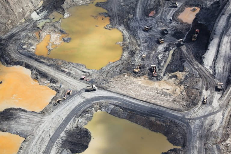
Yet her ministry’s own data, among other references, clearly show rapid deforestation in the river’s watershed. In the past three decades, the 1.8-million-hectare (4.4-million-acre) water catchment area in South Kalimantan lost nearly two-thirds of its natural forest, or an area three times the size of London, according to the data.
Other government sources show a similar trend. According to data from the Indonesian space agency, LAPAN, an area twice the size of London has been deforested in the Barito River’s watershed over the past 10 years. More than half of the 322,000 hectares (800,000 acres) cleared comprised primary and secondary forest and scrubland.
A separate analysis of satellite imagery by Greenpeace shows 304,000 hectares (750,000 acres) of forest lost in South Kalimantan’s watershed areas between 2001 and 2019. It shows the Barito watershed now has less than half of its original forest cover.
Siti said that while the Barito’s catchment area has been largely deforested, the upstream areas still have significant forest cover.
“Using data from 2019, as much as 83.3% of the Barito’s watershed is covered with natural forests, and the rest of 1.3% is plantation forests,” she said. “In this case, the upstream area of the Barito River’s watershed is still well protected.”
Saparis Soedarjanto, the ministry’s director of watershed planning and management, said no amount of forest cover could help the region withstand the amount of rainfall that occurred there during that period, and that flooding was therefore inevitable.
“No matter how dense the forests are in the upstream area, if the hills are steep and the downstream area is flat, then [the region] will be inundated [when there are heavy rains],” Saparis said.
Lana Saria, the environmental director at the Ministry of Energy and Mineral Resources, said mining activity in the region, for which large areas are deforested, makes a positive contribution to the forests.
“It in fact improves the capability of the watershed to become a water catchment area,” she said.
Not functioning well
A top government official, Muhadjir Effendy, the coordinating minister for human development and culture, has taken the opposite stance, saying the flood is evidence that the natural environment in South Kalimantan has become degraded to the point that it can no longer mitigate against natural phenomena like heavy rains.
If the environment were still in good condition, he said, then the extreme rainfall brought by the La Niña weather pattern would not have caused such severe floods.
Baharuddin, an oceanographer at Lambung Mangkurat University in South Kalimantan, backed this view, saying the rapid loss of forest cover in the watershed area contributed to the flooding. When the area was still largely forested, it could handle rainfall of as much as 4,000 millimeters (157 inches) per year, or nearly double the national average for Indonesia, Baharuddin said.
The environment ministry’s own data again supports this point.
“If we look at the environmental service of water management [of the Barito watershed], it’s not 100% functioning well, only 34.2%,” M.S. Karliansyah, the ministry’s head of environmental degradation mitigation and control, said in a televised interview. “Or 65.8% of it is problematic.”
Using data from the country’s geospatial agency, Baharuddin said it’s clear how the watershed area’s forested landscape has been altered beyond recognition by industrial expansion from 1997 to 2019.
“The latest data show the existence of mining activities and monoculture plantations, such as oil palm and rubber, and they’re quite massive and rapid in the Barito watershed,” he said. “Rainfall is the main trigger [of the floods], but land condition that has been deforested can’t be ignored.”
Coal mining concessions account for more than half a million hectares (1.2 million acres) of land throughout South Kalimantan, according to data from the environmental NGO Auriga Nusantara. Almost of all them lie in the Barito watershed, with four-fifths located in areas that serve as water catchment in the watershed.
“It means that almost all the mines in South Kalimantan are located in the upstream area of the Barito watershed, which functions as water catchment,” Auriga Nusantara data director Dedi Pratama Sukmara said as quoted by the Tempo newspaper.
These mines have left trail of destruction, with abandoned mining pits dotted throughout the watershed area, according to Karliansyah.
“We found former mining areas that haven’t been rehabilitated,” he said. “They contribute [to the environmental degradation] in the form of [river] sedimentation that is quite significant.”
Plantations have also come under the spotlight in the wake of the flood. Satellite imagery analysis shows 219,000 hectares (541,000 acres), an area nearly twice the size of Los Angeles, of new plantations established in the Barito watershed in the past decade. In total, plantations cover 650,000 hectares (1.6 million acres), occupying 14% of the Barito’s watershed of 4.5 million hectares (11.1 million acres).
The Agriculture Ministry, meanwhile, identifies 564,632 hectares (1.4 million acres) of oil palm plantations in the province as of 2020.
The environment ministry says most of the non-forested area in the Barito watershed comprises small-scale farms, not plantations.
Muhadjir said the unbridled exploitation of natural resources had damaged the environment in South Kalimantan and brought disasters like the recent flooding. He called for a more sustainable management of natural resources in the region.
“Let’s use nature wisely by fully calculating the benefits and the risks,” he said in a press release. “Don’t let the benefits turn out to be smaller than the risks. Don’t let [a few] reap too much benefits [from the environment], while others bear too high of a risk.”
Banner image: Volunteers and aid workers help the victims of the floods in South Hulu Sungai district in South Kalimantan province, Indonesia. Image courtesy of the Indonesian National Disaster Mitigation Agency (BNPB).
FEEDBACK: Use this form to send a message to the author of this post. If you want to post a public comment, you can do that at the bottom of the page.