- Fifty million hectares (124 million acres) of undesignated forest in the Brazilian Amazon, an area the size of Spain, is under growing threat of illegal occupation and deforestation facilitated by a controversial government land registry.
- A Greenpeace Brazil study shows 62% of undesignated forest along a stretch of the BR-163 Highway has been illegally invaded and then registered by the occupiers with the Rural Environmental Registry (CAR).
- CAR, a self-declaratory system, was created in 2012 to help identify those responsible for rural plots, however, combined with the current weakening of environmental agencies and of field actions against deforestation, it’s helping legitimize land grabbing.
- The problem of land grabbing in the Amazon, often by speculators looking to sell to cattle ranchers and crop growers, is not new, but the situation has intensified under the administration of President Jair Bolsonaro. The Greenpeace researchers say there’s little prospect of a crackdown on land grabbing under the present political scenario.
The Brazilian Amazon is home to public lands that span an area the size of Spain — undesignated forests that are at growing risk of land grabbing encouraged by the state, according to a recent study by Greenpeace.
These public forests, covering a combined 50 million hectares (124 million acres), are not designated for a specific use — unlike conservation units, Indigenous territories, or quilombola (Afro-descendant) settlements, for instance — which leaves them without protection. This allows land grabbers to invade them and stake a claim through the breaches left open by the government’s Rural Environmental Registry (CAR) — a self-declaratory system that some land rights and environmental activists accuse of legitimizing the illegal occupation of public lands.
The practice has been exposed in the recent Greenpeace survey, which shows that 62% of public undesignated forest areas around a stretch of the BR-163 Highway in Pará state were registered in the CAR system. Peppered around conservation units and Indigenous territories in the municipalities of Altamira, Novo Progresso and Itaituba, the total of 2,968 irregular CAR registrations account for an area of forest covering 965,367 hectares (2.3 million acres). “We wanted to understand the dynamics of a certain area, within the undesignated category, and [we chose one] with a history of land grabbing,” Greenpeace Brazil spokeswoman Cristiane Mazzetti told Mongabay.

Analyses based on satellite images and CAR records, among other resources, indicate that the area in question has experienced a new wave of land grabbing, with a significant increase in deforestation and fires, rapid conversion of forests to pastures, and use of knowledge of the local land structure to identify undesignated public forests.
“Hence the need to designate and supervise public lands,” Mazzetti said. “When a protected area is created, the government sends a message that that land will have a use, a purpose, and it cannot be invaded. Between 2004 and 2012, when the Amazon’s annual deforestation rate dropped by more than 80%, new protected areas were created.”
Between August 2019 and July 2020, the area analyzed by Greenpeace saw an increase in deforestation of more than 200%, with 65,582 hectares (162,056 acres) of forest destroyed, compared to 21,480 hectares (53,078 acres) in the previous 12 months. Hotspots, which indicate fires, rose from 3,680 in 2019 to 4,525 as of late October 2020. The region is home to newly described species such as the Mico munduruku, a marmoset, and threatened ones like the golden parakeet (Guaruba guarouba) and the red-nosed cuxiú (Chiropotes albinasus), a monkey.

Self-declared and unchecked registrations
“In the survey we found lands that suffered great deforestation and do not yet have a CAR registry, but we also found areas in which a CAR was registered and soon after they were deforested,” Mazzetti said.
This region of the Amazon is notorious for the lack of transparency over land ownership and registration, compounded by organized environmental crimes and a general lack of government presence. The CAR was created in 2012 to help identify those responsible for rural plots, and has since been credited with slowing deforestation in some parts of the Amazon and the Cerrado grassland biome. But there’s a catch. Mazzeti explains: “The fact that the registry is self-declaratory is the biggest problem. It opens loopholes so that it can be used irregularly on non-designated lands, as well as on protected areas.”
In analyzing the records, the Greenpeace researchers repeatedly encountered the name of Odair José Costa. He’s identified as an agricultural technician who registered 991 plots with the CAR between 2015 and 2020, covering a combined 475,800 hectares (1.1 million acres) in the BR-163 region. Of that total, 586 registrations, corresponding to 167,639 hectares (414,244 acres), were for undesignated public land.
In early 2020, Costa registered three plots on behalf of an Adriele Antunes Melo, spanning a combined 3,969 hectares (9,807 acres). From then through to July, 2,370 hectares (5,856 acres) of that land was deforested; the Greenpeace investigation also showed that Melo, a formal employee of some kind, received emergency aid from the federal government during the COVID-19 pandemic.
“Although the CAR is not a record of property ownership, in practice it has become a land document,” said Pedro Martins, legal adviser for Terra de Direitos, an NGO that advocates for popular movements, communities, and traditional peoples. “What we see now is the political use of that registration as a pressure tool for the agribusiness demand for new lands.”
Since 2012, when the CAR was created under the new Forest Code, land rights NGOs and popular movements “have been warning about this,” Martins told Mongabay. “The [land grabbers’] intention is that illegal registration of public lands indicates alleged possession rights, and the possibility of carrying out land regularization, with the issuance of definitive land titles in the future,” he said. “The data presented by Greenpeace indicate that the land market around the BR-163 Highway is already in high demand, even illegally.”

Public forests threatened by privatization
The results of the study are alarming but not surprising, said Bruno Taitson, public policy analyst at WWF Brazil. “They are part of a current trend, to a greater or lesser extent, in many regions of the country,” he told Mongabay. “It is about the privatization of public lands to serve the interests of illegal deforesters.”
In the eight years since the CAR was established, only 4% percent of land registrations have been validated, Taitson said, citing data from Brazil’s Forest Code Observatory. “That is, until today, in the overwhelming majority of cases, it is not clear if the declared properties correspond, in fact, to the correct [geographical] limits,” he said.
Mazzetti said Greenpeace has sent its case study to the Federal Public Ministry (MPF). “The strong body of evidence of land grabbing needs to be investigated by the MPF, in partnership with IBAMA [Brazil’s environmental protection agency] and the Federal Police. Those CAR registrations, in turn, should be suspended,” Mazzetti said.
The current prospects for change, however, look difficult. Under the administration of President Jair Bolsonaro, the country’s environmental agencies have been weakened, and Attorney General Augusto Aras, who heads the MPF, is an ally of the president. In December 2019, Bolsonaro issued a regulation, known as Provisional Measure (MP) 910, that offers an amnesty for illegal invasions of public lands carried out before 2018. In February last year the MPF denounced MP 910 as whitewashing these illegal occupations, but just months later Aras appointed Juliano Baiocchi, a staunch supporter of the regulation, as coordinator of the MPF’s environmental division.
“Right now we feel hopelessness,” Mazzetti said. “Instead of fighting against a new race for [public] lands, the federal government encourages it, even though the Brazilian population is for the protection of the Amazon.”
Citation:
Azevedo-Ramos, C., Moutinho, P., Arruda, V. L., Stabile, M. C., Alencar, A., Castro, I., & Ribeiro, J. P. (2020). Lawless land in no man’s land: The undesignated public forests in the Brazilian Amazon. Land Use Policy, 99, 104863. doi:10.1016/j.landusepol.2020.104863
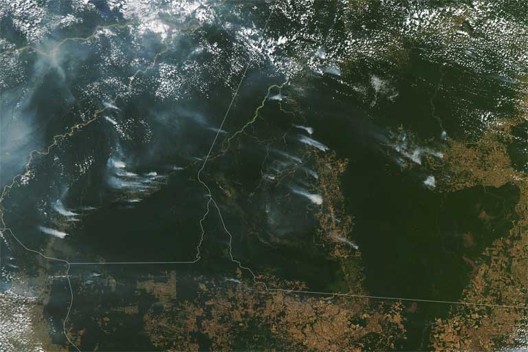
Banner Image: Amazon fires on August 1, 2020 in Brazil’s Amazon. The long, vertical brown line is the BR 163 Highway which gives access to the rainforest. Image courtesy of NASA.