
- A fleet of Chinese-owned fishing vessels crowded along the edge of Ecuador’s exclusive economic zone (EEZ) near the Galápagos Islands between June and September, prompting international concern that they would illegally fish in Ecuador’s territorial waters.
- Several vessels turned off their GPS-based automatic identification systems (AIS), possibly to avoid discovery while partaking in illegal activities, several sources found.
- An analysis of new data, this time from radio signals, not GPS, detected unidentified ships within the Galápagos EEZ, with several of the boats operating immediately adjacent to the Chinese fleet.
- The new data provide additional, but still inconclusive, evidence that the Chinese fleet may have entered Ecuador’s EEZ.
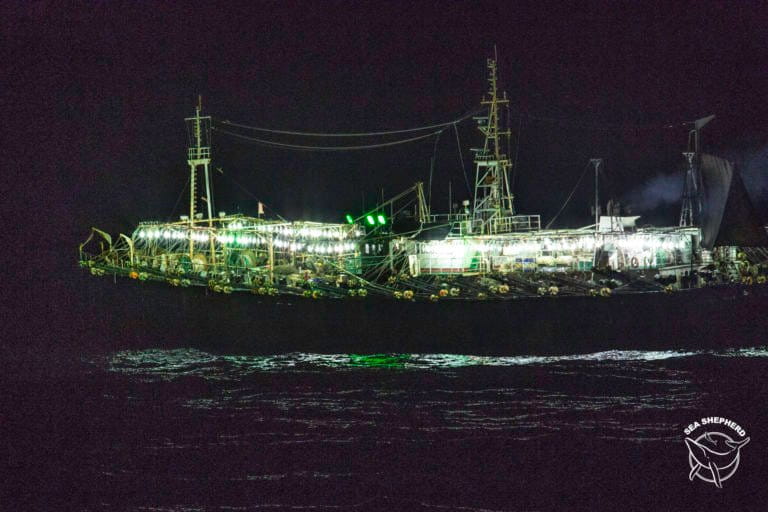
In late June, a fleet of about 300 Chinese fishing vessels swarmed around the rich, biodiverse waters of the Galápagos Islands, armed with overhead lights and industrial jigging machines to attract and catch squid. For the next few months, the vessels remained around the edge of the Ecuadoran islands’ exclusive economic zone (EEZ), raising concerns among conservationists that the fleet would overexploit the squid and capture endangered species such as rays and sharks.
Another worry was also hovering: would the vessels enter the EEZ and illegally fish, putting even more pressure on the delicate marine region and violating Ecuador’s sovereignty?
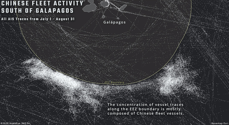
China’s ambassador to Ecuador said the fleet followed international fishing regulations and did not partake in any illegal activity, and Ecuadoran authorities said the fleet did not enter its waters. However, new information released last week by HawkEye 360, a Virginia-based data analytics company, shows that unidentified vessels were indeed present inside the Ecuadoran EEZ at the same time as many Chinese-owned fishing ships were undetectable via their automatic identification system (AIS), a GPS-based system that publicly transmits a vessel’s identity, speed and location.
There’s a strong correlation between these events, but they don’t necessarily confirm that illegal fishing took place, experts say. However, this new layer of information paints a fuller picture of what may have happened at the border of the Galápagos EEZ in the past few months.
It’s a legal requirement for industrial-sized fishing vessels in Ecuador to continuously transmit AIS. There can be legitimate reasons for a break in AIS transmission, such as poor satellite coverage. But in many instances, it indicates that a ship is deliberately trying to hide its location. On 43 occasions between July 13 and Aug. 13 this year, Chinese vessels near the Galápagos turned off their AIS systems and went “dark,” according to a report by the conservation NGO Oceana that relied on data from the Global Fishing Watch ship-tracking platform. On average, these vessels deactivated their AIS for two days at a time, with the longest stretch being around 17 days, the report said.
HawkEye 360 also drew on AIS data to show that many vessels went dark “hundreds of times,” with Chinese-flagged ships representing 87% of the gaps, and 90% of the dark vessels identified as fishing ships.

On Aug. 18, Ecuador’s minister of defense, Oswaldo Jarrín, seemed to corroborate this information by stating that about half of the Chinese fleet had switched off their tracking systems. At this point, the Ecuadoran Navy was monitoring the fleet by air and patrol ship.
While the AIS data, or lack thereof, raised suspicions that the Chinese vessels were turning off their systems to illegally enter the EEZ, it alone cannot provide conclusive evidence of this. HawkEye’s analysis helped fill in some of the gaps.
Using a group of specially equipped satellites, the team at HawkEye, working in collaboration with French aerospace company Airbus Defence and Space, was able to detect vessels via radio frequencies emitted from VHF radio systems, satellite phones and various types of navigational radar systems.
“Basically any signal above a watt in power — between 150 megahertz and 15 gigahertz — we can detect it,” John Serafini, CEO of HawkEye 360, told Mongabay. “We can process it, we can geolocate that signal and then we can track it.”

During a six-week period from mid-July to the end of August, the HawkEye 360 team found 14 vessels inside Ecuador’s EEZ that weren’t transmitting AIS signals and could not be identified. What’s more, six of these unidentified ships were immediately adjacent to the bulk of the Chinese fleet, suggesting that they had broken away from the fleet and traveled a short distance into the EEZ.
“The question is, well, is there a connection?” Adam Bennett, product marketing director for HawkEye 360, told Mongabay. “[A]t the very least, there’s a connection of activity occurring over the boundary, and this appears to be vessels that do not want to be found — they appear to be dark — which is a strong indicator of suspicious behavior.”
Right now, HawkEye 360’s satellite system orbits every five hours, but in the next 18 months that time should be shortened to 40 minutes, Serafini said. The HawkEye team is also developing the technology to be able to identify specific vessels that are not easily detectable through AIS.
Milko Schvartzman, a marine conservation specialist with the Argentine organization Circle of Environmental Policies, who has been tracking the Chinese fleet for years, said the inability of HawkEye 360’s data to identify vessels limited its usefulness.
“It’s great what they have shown,” Schvartzman told Mongabay. “But there’s a problem — they don’t identify any vessel … you don’t know which kind of vessels they are or which nationality. Maybe those vessels are your own country’s vessels, that’s the thing.”
Schvartzman himself made a list of 303 Chinese-owned fishing vessels in the fleet, which aided a Mongabay Latam investigation of 139 of these ships, many of which have a history of illegal fishing. The majority of these vessels have moved on from the Galápagos Islands, and are now fishing along the border of the Peruvian EEZ, he said.
To Schvartzman, the presence of the Chinese-owned fishing fleet near the Galápagos Islands posed not only an environmental problem for the region, but a socioeconomic problem for Ecuador itself due to the navy’s expensive monitoring efforts.
“That’s a big problem,” Schvartzman said. “[It costs] millions of dollars from the local economies to deploy vessels to the area. They turn off their systems because they want to cover what they are doing … and that shows how the Chinese fleet operates.”
Banner image caption: Chinese squid vessel being refuelled by Peruvian tanker. Image by Simon Ager.
Elizabeth Claire Alberts is a staff writer for Mongabay. Follow her on Twitter @ECAlberts.
FEEDBACK: Use this form to send a message to the author of this post. If you want to post a public comment, you can do that at the bottom of the page.