
- A dam developer in Indonesia has rebuffed calls for an independent study to assess the impact of the project on the critically endangered Tapanuli orangutan.
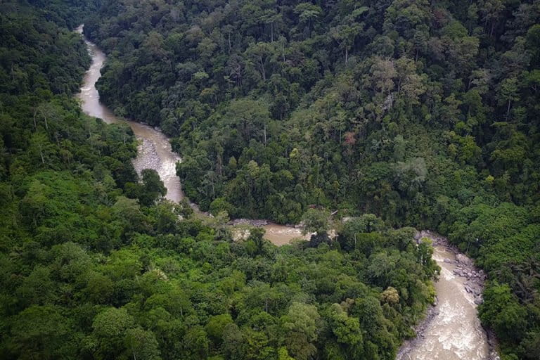
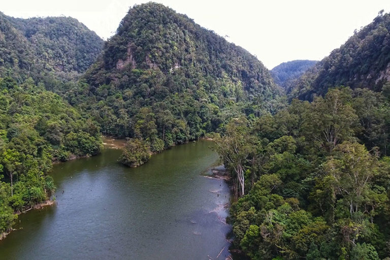
- The species, numbering fewer than 800, is found only in the Batang Toru forest in Sumatra, which is also the site of a hydropower project that conservationists say threatens the survival of the great ape and livelihoods of local communities.
- The IUCN has led calls for an independent assessment, citing a litany of inaccurate and misleading claims stemming from the project developer’s various statements and publications.
JAKARTA — Developers of a hydropower dam that threatens the only known habitat of a critically endangered orangutan say they will push on despite calls from the IUCN for an independent study into the impact of the project.
Emmy Hafild, a senior adviser to project developer PT North Sumatra Hydro Energy (NSHE), said there were “already enough studies” on the ecosystem of the Batang Toru forest in Indonesia’s Sumatra Island, home to the Tapanuli orangutan (Pongo tapanuliensis).
“The problem is that people are picking studies that fit [their agenda] to frame” the project as threatening the environment, she said. She added the best way to save the Tapanuli orangutan is to sustainably manage the ecosystem by involving all stakeholders, including companies operating in the area.
Emmy’s remarks come in the wake of mounting calls from scientists, conservationists and environmental activists for the hydropower project to at least be halted pending an assessment of how it will affect the orangutans. The species, only described in 2017 but already considered the most threatened of the eight great apes, number fewer than 800, concentrated in an area of forest about the size of the Indonesian capital, Jakarta. The three known subpopulations of the ape are separated by the Batang Toru River, and scientists fear the hydropower project will cut off connectivity between the groups.
The latest expression of concern has come from the IUCN, which repeated its earlier call for a moratorium on further construction to allow for a scientific study to be carried out by an independent party.
“No robust studies have yet assessed the importance of the project site for retaining connectivity among the three subpopulations of the orangutan, nor how habitat loss and the infrastructure from the project would affect orangutans in that area,” the IUCN primate specialists’ section on great apes (SGA) said in a blog post.
The IUCN SGA said the independent study would have to be comprehensive and cover at least four areas. The first is a genetic study to determine the pattern of genetic diversity among the orangutan populations living on either side of the Batang Toru River, and how this would be affected by dam infrastructure. The second is a genetic study to determine recent population trends and whether the Tapanuli orangutan had until recently a much larger range. Third is improving estimates of the number of orangutans in all three known subpopulations. And finally, the study would have to quantify the various threats to the orangutans, such as habitat loss and killing.

To protect or not to protect
The dam project and a nearby gold mine are authorized in this part of the Batang Toru forest because the area, although forested, has been designated for conversion under government zoning plans. In 2014, extensive parts of the forest were redesignated as protected area, but not the site of the hydropower project, which was also eligible for protection but had already begun to be developed.
The IUCN SGA says the site should be redesignated as protected as a means of providing greater protection to the Tapanuli orangutan.
“Incorporating the whole non-protected area of which the project area is part into the protected forests of Batang Toru would add further security to the region’s wildlife and vital environmental services,” it said in the blog.
To that end, a scientific study will allow for an unbiased assessment of whether the area truly warrants protected status, and whether projects and economic activities in the area should be relocated to avoid further degradation of the ecosystem, the IUCN SGA says.
But NSHE adviser Emmy says such a study could have the opposite outcome — determining that the area doesn’t warrant protection — and thus open the window for more economic activities in the area.
“It will reveal and provide opportunities for interests other than the necessity to protect the orangutan,” she said. “In reality, this is not a scientific, but a political process that goes beyond the control of both NGOs and scientists, especially scientists from overseas. The outcome is unpredictable and the level of uncertainty is high, since the district heads and local councilors tend to resist any changes to the existing land status that they fought so hard for in the past.”
Emmy said lobbying the government to change the area’s status into protected forest would take a long time, and that that time would be better spent devising measures to protect the orangutan and its habitat. She added that’s why NSHE had established a consortium with the Swiss-based NGO PanEco in 2019 to cooperate on protecting the orangutan.
PanEco initially described the dam as “the greatest threat to the long-term future of the Tapanuli orangutan.” But it toned down its criticism after a reported visit from intelligence officers and a reminder from Emmy that it faced having its permit to work in Indonesia terminated if its staff continued to criticize the dam. Emmy has previously denied threatening the NGO.
“We should focus on [sustainable management], not go back to the process [of converting the area’s status],” she said. “This will help the orangutan to survive much more than going back from the start” to change the status of the area.

Misleading claims
Serge Wich, the co-vice chair of the IUCN SGA and one of the scientists involved in describing the Tapanuli orangutan, said just the fact that the area is the habitat of a critically endangered great ape species should be reason enough to halt all economic activities there.
“I would argue that in an area of a critically endangered great ape it can be highly risky to have economic activity that impacts the area,” he told Mongabay. “That is also why ‘avoidance’ of projects is always the first step in the mitigation hierarchy.”
There are also a litany of uncertainties and unanswered questions regarding the potential impact of the dam and its associated road, earthworks and power line infrastructure on the Tapanuli orangutan, Wich added. These stem from many contradictory claims made about the project’s potential impacts, which were analyzed in a recent fact-check report by the IUCN.
The report identifies several significant claims in NSHE’s publications or press releases as being inaccurate or misleading.
“In at least ten cases, assertions made in public-facing NSHE literature or on the NSHE website are found to be inconsistent with findings presented in earlier impact assessments conducted on behalf of NSHE,” the report says.
One of the biggest misconceptions about the dam project is that because an area is not protected, it is therefore not forested and not important for orangutans. That’s false, says Wich, who points out that non-protected status is a zoning designation that doesn’t indicate whether the land is forested or not.
The IUCN report cites NSHE’s own environmental, social and health impact assessment (ESHIA), which says “the majority of the project area has been mapped as the land class ‘primary forest’ … followed by secondary forest.”
And in 2018, the Indonesian environment ministry’s director-general for conservation, WIratno, said that despite the area’s non-protected status, “the forest cover is still intact.”
Wich said a careful independent assessment of the likely impacts needs to be conducted before deciding how, or even whether, to continue with the project.
“In conservation we should follow the precautionary principle and not develop something of which we do not know the impact,” he said.
And now is the perfect time to do so as the work on the hydropower plant has already been put on hold since January due to pandemic-related health concerns, the IUCN SGA said in the blogpost. An official with the state utility overseeing the project said in July that the project could potentially be delayed by three years due to environmental, funding, and pandemic-related concerns.
“The current delays might be an opportunity for the Indonesian government to propose alternative plans for the Batang Toru area — a life after the dam,” the IUCN said in its blog post. “The most threatened great ape species in the world deserves the highest level of protection. Cancelling the hydropower plans and moving the project, or an alternative option to generate energy, to another, lower-risk location, would show the world that Indonesia takes its international sustainability commitments and national environmental legislation seriously.”
Earthquake risk
Nur Hidayati, the head of the Indonesian Forum for the Environment (Walhi), said an independent scientific study, if carried out, should cover the whole Batang Toru ecosystem as there are multiple other threats to the area.
She cited the example of a gold mine near the hydropower project. The Martabe mine has been operated since 2018 by PT Danusa Tambang Nusantara, a subsidiary of U.K. conglomerate Jardine Matheson (Jardines).
There was a plan to expand the mine to the Tor Uluala peak, where Tapanuli orangutans occur. But following a campaign by Mighty Earth, a U.S.-based environmental advocacy group that has also spoken out against the Batang Toru dam project, Jardines committed in 2019 to not expand further into Tapanuli orangutan habitat.
Threats from other forms of human activity still linger, especially in South Tapanuli district, where a third of the Batang Toru ecosystem lies, without protected status. This includes environmentally sensitive areas that are home to critically endangered species such as the Tapanuli orangutan and Sumatran tiger.
This makes an ecosystem-wide study necessary, said Walhi’s Nur.
“This is important because each project is viewed separately, they don’t consider the [environmental] carrying capacity of the whole ecosystem,” she said. “That’s why there needs to be a strategic environmental impact assessment for the whole Batang Toru ecosystem to see how far the ecosystem has changed.”
Walhi has also previously criticized the dam developer NSHE’s environmental impact assessment, known locally as an Amdal, saying it only considers the narrow physical footprint of the construction project and not its broader ecological effects. The group says the Amdal fails to account for the project’s effects on the livelihoods of people living downstream, or the risk of earthquakes, given the dam’s proposed location on top of the Great Sumatran Fault.
NSHE says the dam isn’t located on a fault, and that the closest active fault is 4 kilometers (2.5 miles) away. It also claims any earthquake in the area would be limited to a magnitude of 6.7 — despite scientific consensus that there’s no way to predict where or when an earthquake will strike, or its magnitude. NSHE nevertheless also claims it’s building the dam in compliance with guidelines from the International Commission on Large Dams (ICOLD).
In its fact-check report, the IUCN cites U.S. Geological Survey data to show that the Sumatran fault has a history of earthquakes stronger than magnitude 6.7, with 15 large earthquakes (magnitude of 7 or greater) on or near Sumatra since 2000. The report also cites a 2014 study mapping the fault planes of large earthquakes along the Sumatran fault since 1892. The study estimates the Tapanuli earthquake of 1892 was of magnitude 7.5 or greater.
Because the magnitude scale is logarithmic, small differences translate into significant impacts. An earthquake of magnitude 7 is nearly twice the size of a magnitude 6.7 event and releases 2.8 times the energy, while one of magnitude 7.5 is more than six times larger, releasing more than 15 times as much energy.
The report also notes a high risk of a large earthquake occurring in the hydropower project area due to a seismic gap — a stretch of the fault line that has not slipped for a considerable time and is therefore at greater risk of doing so.
More inaccurate claims
Another contested claim from NSHE is that the project area is dominated by rubber trees, not primary forest, and thus doesn’t constitute the main habitat for the Tapanuli orangutan. The company bases this claim on three different studies, the most recent of which was carried out by the Jakarta-based National University Center for Sustainable Energy and Resources Management (CSERM), whose head also chairs the NSHE-PanEco consortium’s executive committee.
Wich pointed to a separate study by the environmental consultancy PT Hatfield Indonesia from April 2015 that aimed to identify the different habitat types, such as primary forest, secondary forest, plantations and so on, that are present in the project area. That study indicated nearly 70 percent of the NSHE concession constituted primary forest.
The developer’s own environmental, social and health impact assessment (ESHIA), using the FAO definition for primary forest, concluded that “the majority of the project area is mapped as primary forest.”
Also in question are the developer’s claims about the Tapanuli orangutan’s population and habitat. NSHE puts the population density in the project area at 0.22 to 0.48 individual orangutans per square kilometer, based on nest observations made in 2017 and 2018. It says this “proves that the area for the Batang Toru Hydropower Plant is least used by orangutans, therefore cannot be categorized as main habitat.”
The latest study, also by the CSERM, estimated a population density of 0.32 individuals/km2. Project adviser Emmy cited a 2019 study that she said shows the majority of the orangutan population is found within the protected parts of the Batang Toru forest and not the non-protected areas.
“The Batang Toru hydropower project is located in this area, not in the highest density of orangutan population, as claimed by Serge Wich,” she said.
But the IUCN fact-check again cites the company’s own ESHIA, produced by the consultancy Environmental Resources Management (ERM), which repeatedly notes the significance of the project area as orangutan habitat.
“The outcomes of the critical habitat determination indicate that the primary forest and secondary forest habitats within the Project area are critical habitat for the species along with these habitat types across the Project area of influence and the wider landscape,” the ESHIA document says.
It records average orangutan density of 0.7 individuals/km2 in the project’s area of influence along the west bank of the Batang Toru River. The highest density is in the southern survey area, at 0.95 individuals/km2, which ERM says is almost three times the estimate for the entire Batang Toru forest area.
“Why does Emmy say the density is lower?” Wich said. “The ERM survey [cited in the ESHIA document] does indicate the opposite. She is not really providing anything strong against the fact check report.”
According to the IUCN report, the early studies reporting high orangutan densities, including the ERM survey, are “neglected in favor of recent NSHE-sponsored studies reporting low densities.”
One of the favorable studies frequently cited by the company was carried out in 2018 by the Center of Study, Advocacy and Nature Conservation (Pusaka Kalam) in cooperation with NSHE. It analyzed nest density, and came up with an orangutan population density of 0.22 individuals/km2 on the basis that many of the nests observed by PanEco in 2015 in the project area were no longer in use. This, it claimed, points to the orangutans no longer frequenting this area.
But the premise for this conclusion is contrary to what’s known about orangutan behavior. The IUCN points out that orangutans build a new nest every night, hence it’s normal for nests found in 2015 to no longer be used in 2018. Conservationists also say there might be fewer orangutans in the dam project area than previously documented because the apes, like all wildlife, tend to flee from major disturbances like heavy earthworks and road building.
Even more questionable claims
To this, the NSHE claims on its website that the heavy machinery doesn’t spook the orangutans. “Orangutans continue to conduct a calm behavior around them while on the move, eating and resting,” it says.
Yet again the project’s own ESHIA negates this, citing studies done as a part of a neighboring gold mining impact assessment, which identified a negative correlation between drilling intensity and orangutan population density. The studies also attributed temporary disappearance of orangutans to noise rather than physical habitat loss.
And in 2018, the environment ministry reported that preconstruction activity for the dam and power plant had driven a group of Tapanuli orangutans out of their habitat and into nearby oil palm plantations.
“That’s why it’s important to use precautionary principle,” Wich said. “Why take risks with the future of the Tapanuli orangutan for this project? There are many risks. Electricity can be obtained from other areas with no impact on the Tapanuli orangutan. Why does the project have to be here [in the orangutan habitat]?”
Didik Prasetyo, an orangutan researcher at the CSERM, acknowledged there were indications that the orangutan population declined in the project area when construction work started in 2017, but that it would stabilize when the work winds down.
“We predicted that the orangutans would flee from the area because the construction work started,” he said. “And then in 2018, some returned, as evidenced by the increase in population. And then in 2019, it increased again. So it seems like there’s no more threat because they’ve returned.”
With 90% of the construction work completed, the disturbance has mostly decreased and now the focus should be on rehabilitating impacted areas so that the orangutans feel safe to return, Didik said.
“A process like this won’t go on forever,” he said. “So as long as there are still forests and connectivity [between subpopulations], the orangutans must be safe.”
Ian Singleton, the PanEco conservation director and head of the Sumatran Orangutan Conservation Programme (SOCP), echoed Didik’s remarks, saying the project didn’t infringe on the connectivity of the orangutans and that proper mitigation would minimize the impacts of the dam.
“Compared to other hydro dams, [the deforestation by NSHE] is very small,” he said. “My challenge to NSHE is to have all areas that have been cleared and which they say they will restore, to be restored and returned to their original condition.”
Singleton said there were ways to mitigate the impact of the project, such as a no-disturbance policy for orangutans living across from the dam; planting vegetation by the sides of the roads; and designing the project’s overhead power lines to allow the orangutans to travel safely beneath them.
As long as NSHE carries out these measures, the impact of the dam can be minimized, Singleton said. “And I’m always more concerned on what’s happening and what will happen outside [the dam area],” he said.
Wich questioned how Singleton can be so sure of these outcomes when there’s so much still unknown about the impacts of the project.
“What precedents are there to assure that there will be no expansion of hunting, making plantations, etc.?” he said. “How do we know orangutans will be using whatever connectivity the company aims to provide? Has a study been done on what level of connectivity is needed to guarantee sufficient genetic variation in all populations? We do not even know the genetic variation in all of those now so how can Ian assure that this will all work? Many scientists would be totally unconvinced by what Ian claims.”
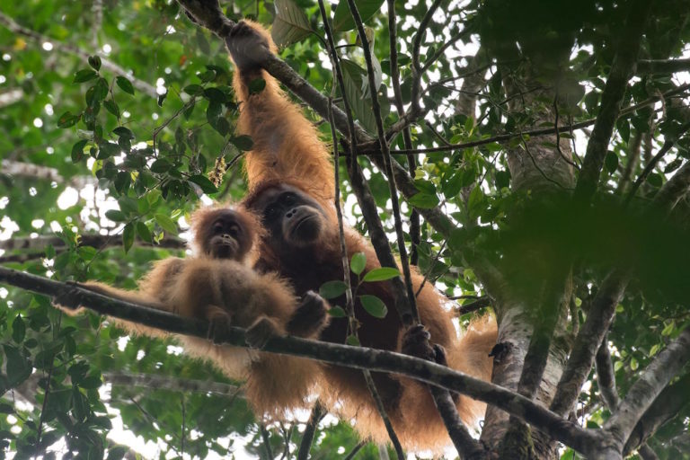
Banner image: A Tapanuli orangutan in the Batang Toru forest, North Sumatra, Indonesia. Image by Matt Senior.
FEEDBACK: Use this form to send a message to the author of this post. If you want to post a public comment, you can do that at the bottom of the page.