
- If it was possible to accurately forecast where Amazon fires were most likely to occur each year, it should theoretically be far easier to prevent and control those fires.
- Amazon fires are currently predicted in two ways: first, based on deforestation, much of it illegal, that occurs in the wet months before the annual fire season; it is these deforested areas that are most often set on fire in the dry months of July through September.
- Second, it’s also possible to predict the approximate severity and Amazon region in which fires may occur based on climate and drought forecasts for the biome, often based on ocean temperatures.
- But being able to predict where Amazon fires might occur is only a first step. A strong, proactive government response is also needed to prevent and control fires, and in order to apprehend and prosecute those who set them ablaze in the Amazon.
The world watched in horror as the Amazon burned in 2019, windblown smoke darkening the sky over far-off São Paulo, Brazil. The ability to predict where fires are likely to occur across the vastness of the Amazon could lead to proactive prevention, faster response and management.
But is it even possible to forecast fires? As it turns out, yes — to a degree.
Fire predictions presently fall into two categories: forecasts of where fires will occur based on deforestation data, and predictions about the severity of the upcoming fire season based on climate data.
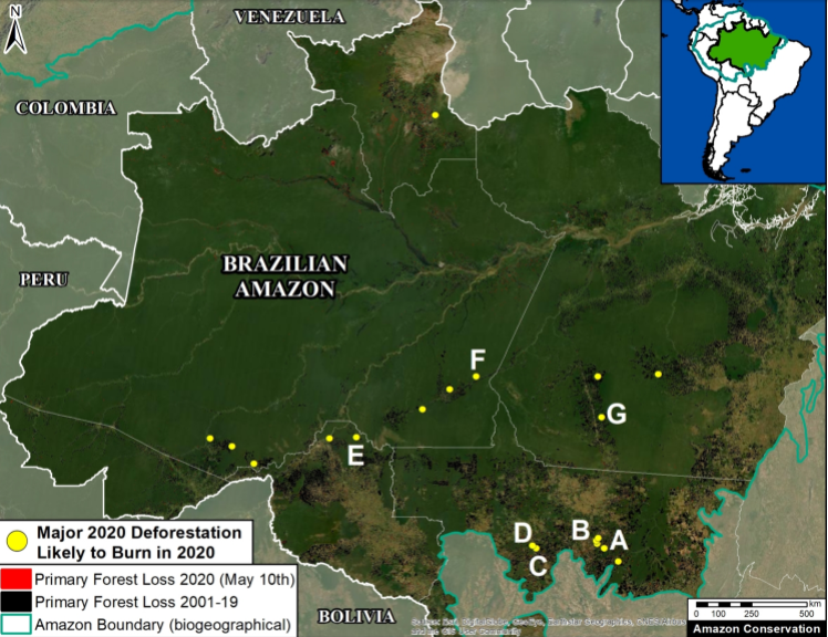
We now know that the 2019 Amazon fires largely followed a pattern of intentional, often illegal, deforestation. Last September, the nonprofit Monitoring of the Andean Amazon Project (MAAP) analyzed archived satellite imagery and found that many of the 2019 fires burned in areas that had been deforested earlier that same year.
Based on large deforestation events detected by satellite in the early months of 2020, MAAP has predicted seven areas that are likely to burn this year. Of that total, four have seen major fires since June.
“Note that all of the deforestation areas are surrounded by primary forest that could be impacted if fires escape. Also note that several deforestation areas are quite large, over 2,000 hectares [5,000 acres],” the MAAP report says.
The link between deforestation and fires works like this: forests are often cut and then set ablaze by land grabbers, farmers, and landowners converting the land for sale and for agribusiness use, particularly cattle pasture. However, a clear-cut rainforest is too dense and wet to burn right after it’s cut down during the rainy season. But after a few months have passed, and as the dry season begins in July and August, these deforested areas can be set on fire and burned over.
MAAP located the areas most likely to see dry season fires using a new method to estimate deforestation of primary forest in the Brazilian Amazon. The method makes use of some advanced global satellite monitoring projects, merging confirmed, high-resolution GLAD alerts from the University of Maryland with DETER alerts generated by the Brazilian space agency, INPE, an institute with decades of expertise in Amazon monitoring.

Satellite imagery of 2,395 deforested hectares (Zone F from the figure above) before and during burning in late July. Imagery via Planet.

Climate analysis as a predictor
While following the trail of deforestation can tell us where fires might occur, climate data can also help us predict the severity of the upcoming fire season. And that data, surprisingly, comes not from the rainforest but from the ocean.
Variations in sea surface temperatures can affect weather patterns around the world on land, including drought potential and intensity, so sea temperature measurements can be used to predict how severe the upcoming fire season might be in the Amazon region.
Sea surface temperatures before the fire season have shown a strong correlation with the number of fires observed via satellite in South America. A warm season in the North Atlantic, for instance, reduces moisture convergence toward the Amazon, which can lead to drought. Droughts and drier years, of course, make forests more prone to burning.
Kátia Fernandes, a climate scientist at the University of Arkansas and the SERVIR-Amazonia Fire and Drought Risk Service Area, and her colleagues created a model that uses north tropical Atlantic sea surface temperatures to forecast fire severity in the western Amazon. This model informs the Seasonal Fire Forecast platform, which displays points on a map where an active fire season is expected. These locations are based on historical data showing local climate response to sea surface temperatures.
Another climate data-based platform, hosted by the University of California, Irvine, makes a seasonal forecast of fire risk across the southern Amazon by analyzing the relationship between climate conditions and active fire detections from NASA satellite instruments.

Both platforms can be used to model what may happen a few months in advance of the fire season, which typically runs from July through September.
Based on climate conditions this year, for instance, the Amazon fire forecast for 2020, co-created by Doug Morton from NASA’s Goddard Space Flight Center and Yang Chen with UC Irvine, suggests 2020 will see an active fire season, similar in magnitude to the fires in 2005 and 2010, which saw record droughts leading to widespread, significant fire activity.
“You have a perfect storm: drought, the recent increase in deforestation, and new difficulties for firefighting. 2020 is set up to be a dangerous year for fires in the Amazon,” Morton said in a statement.
One important caveat regarding fire predictions made via the Amazon seasonal fire forecasts: they only forecast fire likelihood based on climate. Those predictions don’t include variables due to land use and management.
“Fire in the Amazon is not a natural process,” Fernandes told Mongabay. “For instance, even in a very dry year, without human activities, you probably wouldn’t see fires happen. So, there is this component of the fire season we are not accounting for in the forecast. We are only accounting for the climate aspects.
“So, can we predict fire? Yes, we can predict how the climate can impact the fire season. But precisely, no, not yet. Again, because it depends on human activities,” Fernandes said.
The role of government
Another question: can predicting fires help with their prevention and/or management, and if so, how? To answer, we must enter the political and policy realm.
Fire predictions can be used to inform management decisions. In Brazil, for example, the states issue permits for burning. If the seasonal forecast or fire predictions look troubling, they might limit the number of permits issued. In 2010, for example, it was very dry in the western Amazon, so some state agencies reduced the number of burning permits based on this information.
The intense global outcry over last year’s fires resulted in Brazil’s President, Jair Bolsonaro, ordering an Amazon-wide fire ban, with a 120-day ban also issued this year. But the success of state permitting and regionwide bans depends almost entirely on public compliance and government enforcement, which have both been lax.
“Early warning is critical to reduce the ecological and economic consequences of fires in the Amazon region,” Morton told Mongabay in an email. “Given that Amazon forests are not adapted to fires, understory fires in Amazon forests are a lose-lose situation, [with] immediate loss of economic value and long-term losses of ecological values in forests degraded by fire.”
![President Jair Bolsonaro has been criticized for dismantling IBAMA, Brazil's environment agency. In this photo IBAMA agents remove deforestation machinery from the forest. Image by Vinícius Mendonça/Ibama [CC BY 2.0.]](https://imgs.mongabay.com/wp-content/uploads/sites/20/2019/11/25093450/IBAMA_Opera%C3%A7%C3%A3o_Onda_Verde_2014_29310846301.jpg)
Information about where deforestation is happening and where fires are likely to happen, it turns out, is not an issue. INPE, the Brazilian space agency, for instance, has had fire monitoring tools available to the public for decades. But how decision-makers use that information — or whether they use it at all — depends on political will, current policies, and the funding and organizational capacity of fire control and enforcement agencies such as IBAMA, Brazil’s environmental agency. But the Bolsonaro administration, and that of Michel Temer before him, significantly defunded IBAMA; Bolsonaro has also largely handed over the fire suppression role to the Army, which critics say is inexperienced and inefficient at the job.
“They [INPE] have wonderful resources, really impressive,” Fernandes said. “So, knowing where deforestation is happening where fires are occurring, this is not a bottleneck for taking action. What does change over time is investment in law enforcement.”
Prediction data and monitoring, no matter how precise, do little good when regulatory agencies and law enforcement lose the funding and support to conduct on-the-ground fire monitoring, control, or the ability to prosecute those who set illegal fires.
Citations:
Finer, M., & Mamani, N. (2020). Deforestation and Fires in the Brazilian Amazon – 2020. MAAP.
Fernandes, K., Baethgen, W., Bernardes, S., DeFries, R., DeWitt, D. G., Goddard, L., … Uriarte, M. (2011). North tropical Atlantic influence on western Amazon fire season variability. Geophysical Research Letters, 38(12). doi:10.1029/2011gl047392
Banner image of Altamira (-5.79, -53.69) in the State of Pará, Brazil taken on August 8, 2020. Satellite Image Courtesy of Planet.
Liz Kimbrough is a staff writer for Mongabay. Find her on Twitter: @lizkimbrough_
FEEDBACK: Use this form to send a message to the author of this post. If you want to post a public comment, you can do that at the bottom of the page.