
- For more than 10 years, Amazonian indigenous communities in Peru, Ecuador and Colombia have used technology to record environmental crimes, gather evidence, and file complaints with authorities in their countries.
- Prosecutors in these countries attempt to verify complaints, but without coordinated logistics, monitoring work done by communities is not always accepted by government entities.
- Despite this, a number of communities have used technology to win important verdicts against oil companies, while others have successfully compelled governments to evict invaders from their territories.
In 2006, when the first large environmental monitoring project began in the Peruvian Amazon, its objective was not to uncover new environmental crimes in the forest. Instead, the project was aimed at documenting crimes that had affected the communities living there for decades. Martí Orta-Martínez, a biologist and researcher at the International Institute of Social Studies at Erasmus University Rotterdam, was involved in the initial stages of this project. The monitoring involved the use of very basic GPS equipment along the Corrientes River.
The areas surrounding the Corrientes, Tigre and Pastaza rivers are important to the indigenous Achuar, Quechua and Kichwa communities. In 1971, an area of land here was leased to oil companies, and in 2000, members of these indigenous communities began to report contamination of their main sources of water. However, according to Orta-Martínez, these complaints were easily countered by data offered by the oil company Pluspetrol. “The indigenous people’s discourse had no credibility in the meetings with the state,” he says.
But in 2006, the small project on the Corrientes River used technological tools that would allow Western society to recognize their complaints. Since then, indigenous environmental monitors have obtained videos, photos and coordinates of places contaminated by oil along the three rivers. The Peruvian government has also allocated $15 million to remediate the contamination, which, as of November 2019, occurs in more than 1,000 areas.
This special report originally published by Mongabay Latam covers the struggles of the Achuar, Kichwa and Quechua communities here as they work to prove the damage to their territory and to themselves. With contributions from two regional media outlets, El Espectador and GK, we look at five cases focusing on Ecuador, Peru and Colombia.

In Ecuador, there is no prosecutor’s office that specifically handles environmental crimes, and in Colombia, the introduction of technology into some indigenous communities has been relatively recent. Although these countries find themselves in different situations regarding environmental and indigenous justice, they share some serious challenges. These include the lack of collaboration between indigenous communities and the government, in addition to the need for a budget and logistics that would allow environmental complaints to be inspected and verified.
But the need to monitor crimes here is increasingly urgent: the Amazon lost 29.5 million hectares (73 million acres) of primary forest between 2010 and 2017, according to the Amazon Geo-Referenced Socio-Environmental Information Network (RAISG).
Such monitoring also provides further evidence for the vulnerability of environmental defenders. On Nov. 1, 2019, the death of 26-year-old environmental monitor Paulo Paulino Guajajara was reported, for example. He was a member of a group known as the “Guardians of the Forest,” which defended the Araribóia Indigenous Reserve in the northeastern Brazilian state of Maranhão. It is believed that Guajajara was murdered by loggers. More than half of the world’s total murders of environmental leaders in 2018 occurred in Latin America, according to Global Witness.
Indigenous communities lead using technology
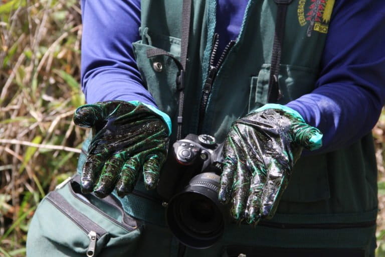
A community of Quechua people living along the Pastaza River in Peru witnessed actions taken by Pluspetrol as the company attempted to manage their first few oil spills. They saw one of the subcontractors setting fire to the crude oil to make it disappear, which caused the destruction of part of the forest. When members of the Achuar community reported the problem, nobody believed them. Pluspetrol said this type of environmental crime could never have occurred. However, an environmental monitor used a small camera to record the burning of the spilled oil. “Pluspetrol claimed that they knew nothing — that the subcontractor was to blame,” Orta-Martínez says. Thus began a new era for indigenous environmental monitors.
Loreto is one of Peru’s regions with the most advanced use of technology to monitor its land: 36 communities comprising four indigenous groups — Kichwa, Tikuna, Yagua and Maijuna — have 120 monitors. They not only defend the Napo and Amazon basins from illegal loggers (using drones and satellite maps), but they have also created the Center for Information and Territorial Planning (CIPTO) in Iquitos, Peru. CIPTO gathers all of the data collected during patrols to be processed by engineers and other professionals.
In Ecuador, the best-known efforts at monitoring have been concentrated in the northeastern part of the country, near the border with Colombia. That is where the Siekopai and Cofán indigenous communities live, along the Aguarico River in Sucumbíos province, and adjacent to the Colombian department of Putumayo. These communities have faced harsh realities due to the advance of mining and oil industries — both operating under the guarantee of the Ecuadoran government.

For the Cofán people who live in the community of Sinangoe on the outskirts of the Ecuadoran oil city of Lago Agrio, daily life includes a mixture of drones, camera traps and satellite map apps. The community gained confidence in technology in 2017, when a routine monitoring exercise detected a group of miners operating on their land. Because they live in a territory spanning more than 55,000 hectares (136,000 acres), the community wondered whether there could be more invaders conducting extractive activities.
After this turning point, the community mastered their use of technology with the help of experts from the NGOs Amazon Frontlines and the Ceibo Alliance. This enabled the Cofán to detect 52 mining concessions that had been granted without consultation. They sent photos, videos and coordinates to prosecutors as evidence, which allowed the community to win a trial against the Ecuadoran government for violating their right to a healthy environment.
The Siekopai people experienced a similar situation in their own fight to curb oil extraction and invasions of their territory. Of their 40,000 hectares (98,800 acres), 191 hectares (472 acres) have been occupied by land traffickers. The issue, which could have been resolved quickly with a simple review of the titling documents, became an odyssey beginning in 2002. However, the community’s use of drones and GPS allowed them to establish their borders and create a map of their territory.
“That evidence is a valuable testimony,” says Donald Moncayo, the sub-coordinator of the Union of People Affected by the Petroleum Operations of Texaco (UDAPT), which was created to confront U.S. oil company Texaco (now a subsidiary of Chevron) after it contaminated Siekopai territory. The organization achieved an important verdict in the Constitutional Court of Ecuador in favor of the indigenous community, and members of UDAPT continue to monitor the area for other threats, such as invasions or oil extraction.
Compared to Peru and Ecuador, Colombia has a more recent history in terms of the use of technology for monitoring indigenous land. By 2015, members of the Inga indigenous community (living in the San Miguel reservation in the department of Putumayo) had endured more than 50 years of activity by an oil industry that did not consider their needs. But after being informed that the Ministry of the Interior had allowed Gran Tierra Energy to begin oil exploration on an additional 629 hectares (1,554 acres) of their territory, they fought back using their new maps.
When the evidence isn’t enough
Although the use of technology has helped some indigenous communities in Colombia, Ecuador and Peru win important battles, there is still no government structure that can validate the evidence provided by indigenous communities.
But of these three countries, Peru has had the most success in terms of its indigenous population managing to establish a clear collaboration with a government institution. In Peru, the photos, videos and GPS information captured by drones are taken into consideration in the investigations conducted by the Agency for Environmental Assessment and Enforcement (OEFA). Since 2017, OEFA has worked with 65 independent environmental monitors from the Achuar, Quechua and Kichwa communities who monitor Oil Block 192 (formerly known as 1AB). When monitors send reports of contaminated areas and their geo-referenced data to the OEFA, the agency uses that information to verify those points in the field.
However, the rest of Peru’s government and judicial system lacks support for this type of evidence. Since 2014, a bill has been discussed in the Peruvian Congress that would provide legal support for the evidence — mainly photos, videos and maps — collected by indigenous monitors. However, this bill has not been acted on during the last two parliamentary periods.
There is also no register of all the complaints or evidence provided by the indigenous monitors. Although an “Environmental Observatory” has been implemented by Peru’s judicial system to keep accounts of such cases, it does not include a filter that would allow for separation of cases related to indigenous groups. Duberlí Rodríguez, president of the National Commission for Environmental Management of the Judiciary, says another shortcoming is the lack of technology to corroborate information provided by indigenous communities.
The outlook is even less encouraging in the other countries. In Colombia, for example, the use of technology by indigenous communities to gather evidence is less frequent, according to the Office of the Special Prosecutor against Human Rights Violations: “It is unusual for us to manage investigations in which the evidentiary material is provided by these communities through the use of technology. Without a doubt, it would be useful if these populations could easily use tools, such as geographic referencing systems, to more effectively gain control.”
According to this office, the mobile messaging platform WhatsApp is one of the tools that some communities use to transmit information about incidents that affect their land. The problem is that these alerts are not always useful. “The investigations begin when there is physical documentary evidence — when there is at least one right to petition. Otherwise, it is very difficult to open a [legal] process,” the prosecutor’s office says.
Ecuador, on the other hand, lacks prosecutors who specialize in the environment. There, environmental crimes are categorized based on their characteristics. Forest fires, crimes against wild flora and fauna, crimes that damage the soil, and illegal mining all fall under Chapter Four of the Penal Code, which are dealt with by the Office of the Prosecutor Specializing in People and Guarantees. Crimes such as illegal oil extraction are handled by the Office of the Special Prosecutor in Transnational and International Organized Crime (FEDOTI).

Verónica Potes, an Ecuadoran lawyer who specializes in the environment and indigenous rights, says a potential solution could be to train all prosecutors to handle environmental crimes to avoid being restricted to the creation of prosecutors who specialize in a particular topic. She says that approximately 10 years ago, “an environmental prosecutor’s office was operating in Lago Agrio; it operated inside the same building as one of the country’s largest oil companies.”
The lack of specialized personnel in the judicial system is a problem that reaches beyond Ecuador to Colombia and Peru. Carlos Lozano Acosta, a lawyer for Colombia’s branch of the Interamerican Association for Environmental Defense (AIDA), says the evidence indigenous people collect as they monitor areas exemplifies a clear challenge within judicial processes. “To consider as evidence an element, such as a map or videos of communities, there must be a deliberative process — a litigation — in which the opposing party can also present appeals,” he says.
This search for impartiality often becomes a bottleneck. “A test should be independent from its parties, and it requires the hiring of experts to do technical analyses, but there are not sufficient personnel trained to do so,” Lozano says.
In Peru, the lack of technology within the Public Ministry and the judicial system is an obstacle whenever evidence needs to be verified. Mariano Castro, the former deputy minister for environmental management at the Ministry of the Environment, says only a very small percentage of complaints have an expert report. “It has been found that less than 1% have this report, which helps to support the complaint,” Castro says.
Flor de María Vega Zapata, Peru’s national coordinator for environmental prosecutors, says that although the Public Ministry views indigenous environmental monitors as allies, the lack of personnel —both in the prosecutors’ technological units and in the environmental police — makes the verification of complaints difficult. “We have, on average, only two environmental police officers per region to conduct operations, and we do not have the vehicles or the equipment necessary to mobilize ourselves quickly when faced with these complaints,” Zapata says.

However, some specialized prosecutors’ offices in the Peruvian rainforest, such as in the departments of Loreto, Ucayali and Madre de Dios, have already had their first few experiences of joint work with this group of indigenous monitors.
The environmental prosecutor of Ucayali, José Guzmán, points to the experience he had with the communities of Nueva Saposoa and Patria Nueva, which border Sierra del Divisor National Park. “We obtained their complaints that included drone images, with exact coordinates, and we intervened four times to evict invaders and illegal loggers,” Guzmán says. “In these Shipibo communities, now the deforestation is at zero.”
Another Peruvian organization that has begun to work with indigenous monitors is the National Service of Natural Protected Areas (SERNANP). The organization has focused on the Amarakaeri Communal Reserve in Madre de Dios and in Sierra del Divisor National Park in Ucayali, where the work carried out by forest rangers with SMART technology is complemented by the indigenous communities’ drones. “We have 750 park rangers for 17 million hectares [42 million acres] of protected natural areas. We need these types of alliances, which also benefit nearby communities, so that environmental threats are identified in time,” says Marco Arenas, the head of monitoring programs at SERNANP.
For more than 10 years, this work within indigenous communities has grown. However, according to Tuntiak Katan, coordinator of the group Indigenous Organizations of the Amazon River Basin (COICA), what’s needed now are projects that further integrate the rainforest. “What I see is that they continue to provide small models, which — although they are important at the local level — should move up to the level of the Amazon biome, with technology that originates in the same communities,” Katan says.
The importance of these achievements may best be summarized in an anecdote shared by Amazon Frontlines lawyer María Espinoza in discussing the case of the Cofán community: “I recall that in the Sinangoe case, in both the first and the second instance, the judges ordered that an inspection be done. A drone flew in front of them, and the judges could see the intact state of the territory and they could understand the scope that would be implicated by allowing mining activity in that area.” This represents the power of technology for indigenous communities.
Banner image courtesy of Kipu Visual.
This article was first published by Mongabay Latam on November 4, 2019.