
- More than a million hectares across Indonesia burned in 2019, according to the government’s numbers. The fires released an estimated 708 million tons of carbon dioxide equivalent (CO2e) in the atmosphere, costing the country more than $5 billion in economic losses that year, according to the World Bank.
- Sumatra was particularly affected, with fires consuming large swaths of primary forest in protected areas like Berbak-Sembilang National Park, which is home to endangered wildlife like Sumatran tigers and elephants, and false gharials.
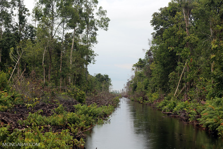
- Illegal logging and the expansion of plantations in the region area over the past decades has rapidly transformed the park and the surrounding area, draining peat swamps and turning them into degraded, easily flammable patches of land. Following Indonesia’s peatland destruction-fueled fire crisis of 2015 President Joko Widodo established the Peatland Restoration Agency (BRG) in Jakarta in 2016. The agency planned to restore over 2.6 million hectares of degraded peatlands, including those in concession areas and in protected areas like Berbak-Sembilang.
- However, BRG president Nazir Foed acknowledged that restoration “progress has not been optimal.” Critics say the effort has been stymied by a lack of collaboration between stakeholders and a lack of consensus on what even constitutes a restored peatland.
In September 2019, the noon sky over a part of Jambi province in Indonesian Sumatra turned crimson. Fires had been raging through Indonesia for the past few months, and certain pollutants in the thick haze that had enveloped the area scattered red light more than blue, scientists said, giving a ruddy hue to the sky.
The red sky didn’t last long, but the haze did. And the devastation from the fires was widespread. More than a million hectares across the country burned, according to the government’s numbers. The fires released an estimated 708 million tons of carbon dioxide equivalent (CO2e) in the atmosphere, costing the country more than $5 billion in economic losses that year, according to the World Bank.
Protected areas burned, too. Within Jambi, the fires scorched parts of Berbak National Park, one of the last remaining vast expanses of peat swamp and freshwater swamp forest in Indonesia and the country’s first Ramsar Site. Large areas also burned in adjoining Sembilang National Park in South Sumatra province, which is hemmed in the east by extensive mangrove forests.
Together, Berbak National Park and Sembilang National Park – merged into Berbak-Sembilang National Park (BSNP) under the same management in 2016 – are home to immensely rich and diverse habitats that harbor hundreds of species including the critically endangered Sumatran tiger (Panthera tigris sumatrae), Sumatran elephant (Elephas maximus sumatranus), painted terrapin (Batagur borneoensis), helmeted hornbill (Rhinoplax vigil), and the endangered Malayan tapir (Tapirus indicus).

But during the 2019 fires, more than 31,000 hectares of BSNP burned, said Dicky Simorangkir, Indonesia Country Director of Zoological Society of London (ZSL). These fires forced some tigers out of the forests, Simorangkir added, resulting in at least five recorded incidents of human-tiger conflict in nearby villages. “The forest fires also increase the potential for habitat fragmentation,” he said. “As habitat becomes fragmented, sub-populations of tigers get isolated, which could limit tiger movement, eventually threatening the viability of the park’s tiger population.”
No stranger to fire
Berbak, located on the southeastern edge of Jambi province, was first declared a wildlife reserve in 1935 under Dutch law, established as a Wetland of International Importance under the Ramsar Convention in 1992, then subsequently designated a national park in 1997. The park has a unique mix of habitats. The lowland forests, rich in more than 260 species of flowering plants including 23 species of palms, are dissected by the Air Hitam Laut River (translating to “black water flowing to the sea”) and its tributaries that are home to both the saltwater crocodile (Crocodylus porosus) and the false gharial (Tomistoma schlegelii).

The forests stand mostly on peat, which is composed of water and the trapped remains of fallen trees, branches, and other plant matter that have accumulated in water-logged conditions over thousands of years. The wet peat is vital for carbon sequestration: it prevents the built-up carbon matter from decomposing, in turn keeping carbon locked away from the atmosphere. In some parts of Berbak National Park, the peat is very thick, reaching depths of over 15 meters (49 feet).
However, illegal logging and the expansion of plantations in the area over the past decades has rapidly transformed the park and its surrounding regions, draining peat swamps and turning them into degraded, easily flammable patches of land. The conversion of peatlands in the Berbak region started in the 1960s. But it gained pace in the 1990s with the spread of tree plantations established to feed the palm oil and pulp and paper industries.
In Jambi, a 2019 study estimated that of the 700,000 hectares of peatlands in the province, about 98,000 hectares occur in Berbak National Park (estimates of peatland extents, however, vary depending on what method is used). By 2014, 66% of these peatlands had been converted to oil palm plantations, the study found. In fact, between 2002 and 2019, the overall Berbak-Sembilang landscape across Jambi and South Sumatra provinces lost over 91,500 hectares of primary forest, according to satellite data from the University of Maryland visualized on Global Forest Watch (GFW).
“The analysis conducted by the GFW team finds that in both South Sumatra and Jambi provinces of Indonesia, most intact forests and peatlands are now deforested or degraded and converted for large scale agriculture activities, mostly a combination of palm oil, pulp and paper companies and also selective logging,” said Arief Wijaya, Climate and Forests Senior Manager of WRI Indonesia.

The conversion of peat swamp forests to plantations involves both large-scale clearing of trees as well as digging of canals and trenches into the peat to drain water from the peatland. As water is drained and cleared stands of trees allow more sunlight to penetrate, the peat begins to dry out, causing its stored carbon matter to decompose in the absence of acidic water and escape into the atmosphere as carbon dioxide.
“Many of the areas that are cultivated [in Jambi] are still being deeply drained – especially within industrial scale plantations of acacia and oil palm, as well as in some smallholder oil palm areas,” said Eleanor Warren-Thomas, currently a researcher at Bangor University.
This degradation has made Berbak prone to repeated fires. Dry peat is combustible and burns easily, releasing even more greenhouse gases in the instance of fire. When prolonged dry conditions persist, a mindlessly flicked cigarette or a small fire that was meant to clear the land for agriculture in a controlled way can quickly turn unmanageable, spreading far and wide, and penetrating into protected areas like Berbak and Sembilang.
Peat fires have been occurring for years in drained peatlands, the Ramsar Advisory Mission to Berbak National Park wrote in their 2017 report. But the problem has been exacerbated by the massive expansion of drained areas coupled with the increased strength of El Niño events, a cyclical climate phenomenon during which the surface waters in the eastern tropical Pacific Ocean become unusually warm, the report noted.
During the 1997-98 El Niño event, for instance, Indonesian peat fires released massive amounts of carbon, equivalent to 13 to 40% of the average annual global carbon emissions from fossil fuels then, a 2002 study estimated. These fires burned about 17,000 hectares of the core area of Berbak National Park, largely along the Air Hitam Laut River, according to a 2006 study.
Similarly, megafires during the 2015 El Niño event burned around 800,000 hectares of peatlands in Sumatra and Kalimantan, the Ramsar Advisory Mission report noted, including significant portions of Berbak and Sembilang.
“These fires destroy forests and farms, affecting local livelihoods and resulting in very poor air quality,” said Jane Hill, a professor at the University of York, who’s leading a project to understand tropical peatlands. “Forest areas which have been burned are unlikely to recover, and many get converted to farmland and plantations.”
Restoring peatlands, reducing fires
Following Indonesia’s peatland destruction-fueled fire crisis of 2015, and the criticism that followed, President Joko Widodo established the Peatland Restoration Agency (BRG) in Jakarta in 2016. The agency planned to restore over 2.6 million hectares of degraded peatlands, including those in concession areas and in protected areas like Berbak-Sembilang National Park through a 3R approach: rewetting, that is, raising water levels of the peatland; revegetation, that is, establishing a forest cover that would reduce fire risk; and revitalization of alternative livelihoods for communities.
As part of the restoration efforts, peatlands around Berbak National Park were also “rewetted” by blocking canals and numerous seedlings of some peat swamp species were planted. But overall targets in the country haven’t been achieved. Researchers say this is partly because of the absence of inclusive collaboration between the local communities and governmental agencies, and a lack of understanding of how restoration efforts will impact their livelihoods. In addition, stakeholders often don’t agree about how effective restoration activities have been or even what a restored peatland landscape should look like, according to a recent study.
The effectiveness of the restoration efforts were questioned after the 2019 fires in particular, during which around 42% of fire alerts detected by satellites occurred on peatlands, according to data from NASA, comparable to 40% of the fire alerts in 2015.
Authorities from both Berbak-Sembilang National Park and the Peatland Restoration Agency did not respond to questions from Mongabay. But in an interview with Indonesian magazine Tempo, BRG president Nazir Foed acknowledged that restoration “progress has not been optimal.”
Berbak and Sembilang together host nearly 300 known species of plants, 44 species of reptiles, 95 fish species and 53 mammals among others, according to Simorangkir of ZSL. The two parks, both Ramsar sites, are Important Bird and Biodiversity Areas (IBAs), and the landscape is a key stopover site in the East Asian–Australasia Flyway, one of the major annual routes taken by migratory shorebirds.
Fires have the power to transform the primary swamp forests of Berbak and affect where birds live. A recent study found that primary forest sites harbored twice as many species of high conservation value (that is, considered at least “near threatened” by the IUCN Red List) compared to similar areas that have been altered by fire. The latter, the authors wrote, had more mobile, widespread species like bulbuls and kingfishers.
Fires may have even contributed to the decline of reptiles like the false gharial in the park in the past, researchers have found, by destroying potential nesting sites.
The Berbak-Sembilang landscape is also a major Tiger Conservation Landscape for the critically endangered Sumatran tiger (Panthera tigris sumatrae). Estimates from ZSL, which has been supporting Berbak Sembilang National Park Agency in monitoring tiger populations, suggest there are around 32 tigers in BSNP. “This population [has been] relatively stable over the last 10 years,” Simorangkir said.
Poaching, Simorangkir added, is a threat to the tigers, although fewer tiger deaths were recorded in recent years relative to the past. “Only one case of tiger poaching in Berbak Sembilang was recorded in 2017,” he said. “Although some snares were still found, the decreased number of tiger deaths signals that efforts undertaken to eliminate poaching has resulted in some impacts.”

However, the conversion of peat swamp forest in and around Berbak-Sembilang to plantations, together with uncontrollable forest fires, is both fragmenting tiger habitat and increasing human-wildlife conflicts as animals are pushed into developed areas.
For the parks’ wildlife and forests to persist, peat restoration efforts must continue across the region, researchers say.
“Keeping peatland carbon in the ground is really important for combatting climate change,” Warren-Thomas said. “There are so few forest fragments left in the lowlands of Sumatra, Jambi’s peat forests are real havens that must be protected, both for carbon and for biodiversity. Peatlands also provide land for many smallholder farmers, as well as supporting industrial plantations that are important for the regional economy.”
Banner image by Rhett A. Butler/Mongabay.
Editor’s note: This story was powered by Places to Watch, a Global Forest Watch (GFW) initiative designed to quickly identify concerning forest loss around the world and catalyze further investigation of these areas. Places to Watch draws on a combination of near-real-time satellite data, automated algorithms and field intelligence to identify new areas on a monthly basis. In partnership with Mongabay, GFW is supporting data-driven journalism by providing data and maps generated by Places to Watch. Mongabay maintains complete editorial independence over the stories reported using this data.
Feedback: Use this form to send a message to the editor of this post. If you want to post a public comment, you can do that at the bottom of the page.