- For five years, the indigenous Matsés people of the Peruvian Amazon region of Loreto explored their territory to georeference everything of cultural value to them.
- Now, all of those places are included on a map in the Matsés language.
- The map will be used to protect their lands from encroachment and development concessions, as well as to teach young people and children about respecting their cultural heritage.
For the past five years, the indigenous Matsés people of the Peruvian Amazon region of Loreto ventured deep into their territory to draw up a complete map of everything that has cultural value to them. Their land is located in Yaquerana district, in the province of Requena, an area that borders Brazil. They georeferenced and created virtual maps of more than 500,000 hectares (1.2 million acres) of forests, rivers, headwaters, places of historical importance, and everything of value to the indigenous community.
“This map will help us defend our territory. Many times, when the government wanted to allow oil companies to enter our lands, they told us that it was not our territory,” says Daniel Vela, head of the Matsés community.

A report created by experts from Acaté Amazon Conservation, an organization that facilitated the expeditions and whose Matses staff accompanied the hikes to collect information across their entire territory, notes that before, the only maps available were created by outsiders who left empty spaces and widely scattered points along the rivers. “For the Matsés, the blank areas on the maps are not voids but are the living heart of their territory,” the report says.
The places marked on the maps were chosen by missionaries and identified with names in Spanish. Now, with the mapping initiative, it has been possible to include all the places that the Matsés consider important for their culture and, for the first time, these have names in their language.
Five years of work
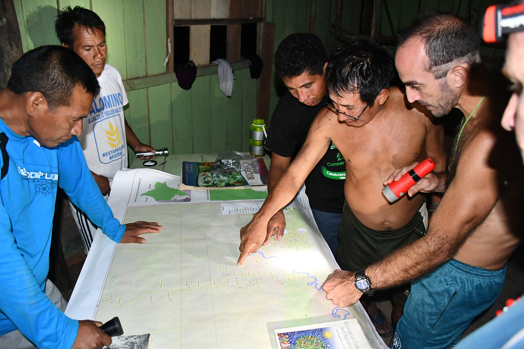
For this, a group of Matsés were trained how to use mapping software, computers and GPS units. One of their first expeditions was to the headwaters of the Gálvez and Loboyacu rivers. For this, they formed teams comprising of one Matsés GPS expert, one elder from the community, and a young Matsés.
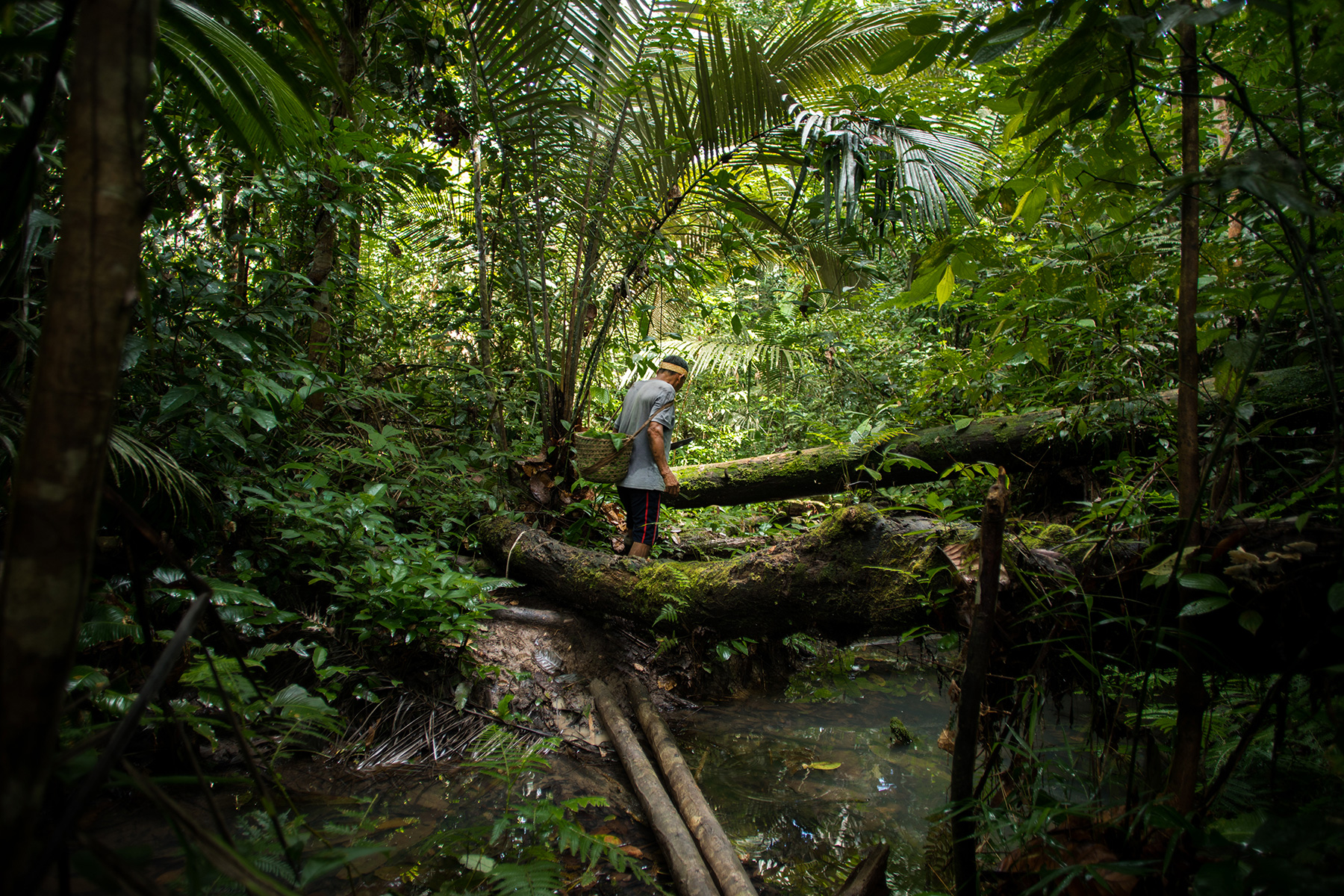
The team visited river basins in search of some of the most important historical sites for the ethnic group. It took two months to gradually build the map of the Matsés territory and complete the expedition.
“Teams of three people worked on each village of the community. Once each area was georeferenced, the information was transferred to the computer,” Vela says.
The hikes were quite long, considering that many of the ancestral sites are located deep in the headwaters because before their first contact with the outside world in 1969, the Matsés lived far from the navigable rivers and streams to avoid encountering non-indigenous people who wanted to kill them. Hikes through swamps and untouched forest led the team to sites of great historical significance.
“The elders will always need that map to teach the children where the ancient warriors lived and to show the extent of our territory. We did it to defend our territory,” Vela says.


According to the Acaté Amazon Conservation report, when data from the Matsés National Reserve and Sierra del Divisor National Park were added to the maps, they observed that their areas were superimposed with the indigenous territories of the Matsés. Before, they didn’t have a map that showed the total extent of their territory.
Now, though, Vela says the new map can be presented to the appropriate authorities in defense of everything that belongs to them. And most importantly, he adds, it will serve to teach children and young people in schools about their culture, history and territory.
The mapping considered 17 categories, including places of cultural importance, ancestral villages, burial sites, waterways, and ecological areas for hunting, fishing, gathering and capture.
“With the map, younger generations will never forget our history and will be able to defend our territory,” says Rómulo Tëca Nacua Chapa, from the village of Puerto Alegre, who led the expedition to map the headwaters of the Yavari River.


During the expeditions, each team carried a camera and a handheld GPS unit. “The younger Matsés’ job was to document as much information about the localities from the elders as possible,” the Acaté Amazon Conservation report says.
“Before I did not know how to use a computer, now I am making maps to mark the territory of my people,” says Felipe Ëpë Bai Unan, who has become an expert in the use of mapping technology.
A renewed respect for their territory
“Mapping is a very interesting process because it implies the cultural revitalization of a community,” says Beatriz Huertas, an anthropologist specializing in the study of indigenous peoples.

Huertas adds that, through this process, indigenous peoples are recognizing their ancestral settlements and sacred areas, identifying their rivers, the places of production of certain resources, among other characteristics of the areas they occupy. “It involves the transmission of knowledge about their territory and the transmission of knowledge from old to young and children. It is the revitalization of their culture and identity.”
The Matsés territory protects intact forests and indigenous peoples in isolation, as their lands border the proposed Yavari Tapiche indigenous reserve, still waiting to be recognized by the Peruvian government as an area of uncontacted indigenous peoples.
“These maps are the basis for territorial governance and they serve to strengthen the administrative, economic and cultural appropriation of their land. But it is also used to define areas threatened by invasions, coca cultivation, logging, among others,” Huertas says, adding these maps made by indigenous people are a political tool to support their demands to the government.
During the mapping process, the Peruvian government attempted to create a 10-kilometer (6-mile) buffer zone within Matsés territory on the Upper Yavari, exceeding previously agreed limits. Even though the proposal was rejected, it reinforced the need for the community to demarcate their traditional territories.
Huertas says the Matsés people have been threatened by loggers for a long time, and there is also a proposal to build a road from the village of Colonia Angamos to Jenaro Herrera, crossing through Matsés land. “This road has been promoted by merchants from Colonia Angamos, capital of the Yaquerana district, but it is a threat to the Matsés territory because it would become a road for land and drug traffickers,” she says.


Christopher Herndon, president and co-founder of Acaté Amazon Conservation, says that before beginning this project, the Matsés elders were not passing down their ancestral knowledge to younger generations. Now, though, they have even created the Matsés Traditional Medicine Encyclopedia.
“We are seeing that young Matsés men and women, who face racism and discrimination outside their territory, have now become leaders with a renewed pride in their culture and with the decision to continue the legacy of their people,” he says.
Christopher Herndon was interviewed on Mongabay’s podcast about the Matsés medicine encyclopedia, volume 2 of which has now been completed and which now spans 1,000 pages.
This article was first published by Mongabay Latam on April 9, 2020. A Spanish version is the video is available on youtube.
Corrections (May 6, 2020): The original version of this article inaccurately stated that Acaté Amazon Conservation accompanied the Matsés on the hikes. Acaté did not accompany the Matsés on a single trip over five years. The entire mapping was done by the Matsés.
The original version of this article inaccurately stated that the Matsés “used to be guided by maps created by outsiders”. The Matsés know their territory with profound intimacy and were never guided or ever need to use the missionaries map.
We also corrected two passages that got inadvertently duplicated.