
- A new study reveals that nearly 5,400 hectares (13,300 acres) of forests have been converted into mining ponds in the Madre de Dios region of Peru.
- The ponds have become contaminated with mercury and other chemicals in the mining process.
- Researchers analyzed satellite and drone images to evaluate the effects of illegal mining and related activities on the forest.
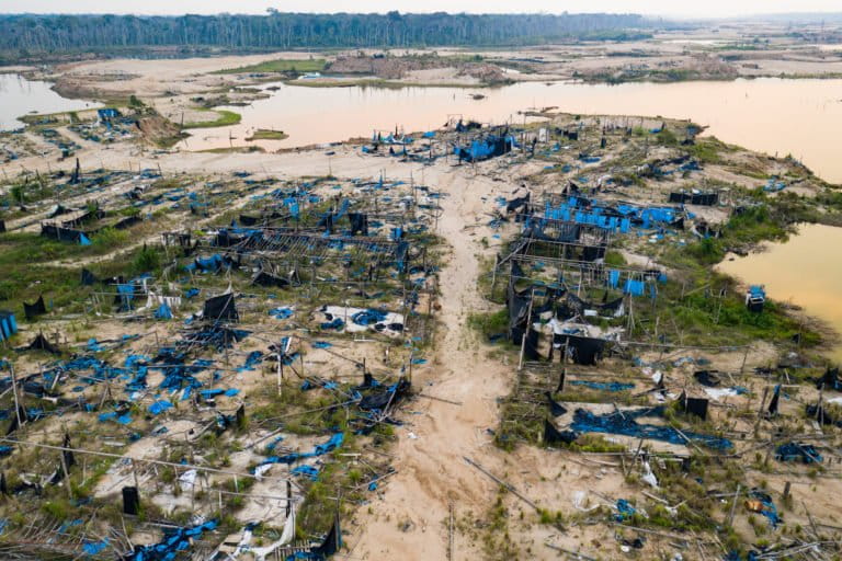
Scientists who spent five years studying the impact of illegal mining in Peru’s southeastern Madre de Dios department recently explored that impact in La Pampa, a geographic area in the region. They found that sites where trees once stood tall now resembled desert, with piles of sand and stone covering the ground. As they traversed the land, the researchers found ponds, visible during flyovers, filled with brown, turquoise and green water. The state of these ponds suggested to them that the tropical forest in the area may not rebound.
“There are 5,377 hectares [13,287 acres] of forest that have been converted into ponds of water. In other words, the tropical forests are not going to return; they will be gone for several generations,” said Luis Fernández, executive director of Wake Forest University’s Center for Amazonian Scientific Innovation (CINCIA) and assistant research professor in the university’s Department of Biology.

To determine the extent of these ponds containing mercury and cyanide, the researchers examined changes in the ground between 2016 and 2019 with the help of images from drones and satellites.
According to the study published by the team from CINCIA, there has been extensive “conversion of forested landscapes to Amazonian wetlands through gold mining.” The mining ponds dug in La Pampa to separate gold from ore cover nearly a third of the 18,000 hectares (44,500 acres) of forest in the area.
A forest full of ponds
“I was surprised by the number of ponds that are in this place. This has been a tremendous transformation in one of the treasures of Peru’s system of natural protected areas,” Fernández said.

Fernández said restoration plans for areas that now contain ponds are practically impossible to execute, given that trees cannot be planted where the ground no longer exists.
“A vast and novel complex of wetlands has been created in an area that, historically, was primary tropical forest, radically altering biodiversity and the potential recuperation of the ground,” the CINCIA study says.
Fernández called this a violent transformation on a landscape-wide level, since new wetlands have been created and it is unknown what effects will be caused by these ponds filled with toxic metals like mercury and cyanide. “How will these metals affect the wildlife that is returning?” he said.

So far, according to the study, researchers have detected the presence of species that were not typically present in the area before. These include birds like the Brazilian duck (Amazonetta brasiliensis), the southern lapwing (Vanellus chilensis), the southern crested caracara (Caracara plancus), and the burrowing owl (Athene cunicularia). Fernández said the researchers are also concerned because some fish and giant otters from the Amazon River have begun to populate the space.
“Little is known about the biodiversity and chemical composition of these mining ponds and the risks that they can pose for wildlife due to mercury contamination,” he said.
The curse of mercury
Karina Garay, a lawyer with Peru’s Specialized Environmental Prosecutor’s Office, has also been to the area. “It is verified that populations cannot be established in that area due to the high levels of mercury, nor do they grow plantains, cocoa, or other [products] typical of the region due to the contamination,” said Garay, who has been in charge of La Pampa since 2019.

Garay added that a large amount of plastic has been found in La Pampa. While much of this plastic is from food and beverage packaging, It also includes sheeting to cover and conceal machinery inside the ponds ahead of raids.
“How do we reforest, with native species, the areas without ground and where there is almost no sand?” Fernández said. “We are putting emphasis on the place where the state is planning restoration.”
Fernández added that the study can also serve to prevent environmental harm in other protected areas and places in which illegal mining is increasing, like the Peruvian departments of Amazonas and Huánuco.
César Ipenza, a lawyer who specializes in environmental matters, said the fish in the ponds attract other species that eat them. The problem, according to Ipenza, is that if the original fish are contaminated, the food chain will be affected.
In terms of the reforestation plans, Ipenza said it is important to define the species that would be reintroduced. “We cannot opt for [plants] that retain mercury that would later accumulate in their fruits. There should be a process of remediation, recuperation, and revegetation with pioneer and colonizing plant species that would help other [plants] to appear,” he said.
Ipenza also called attention to the need for scientific studies to be taken into account. “In this case, it is important to know about the work done by CINCIA, like studies and pilot projects, so that we know which tree species are most appropriate for this area.”
Three years of change in images
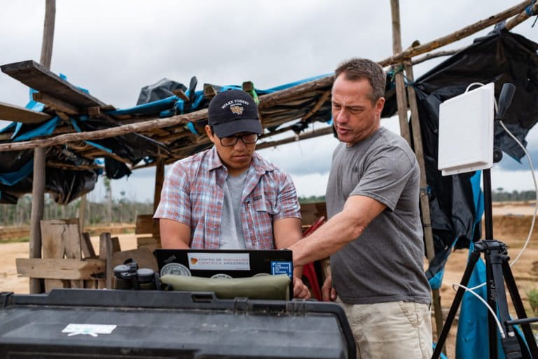
“We saw this transformation — how the forests and aguajales [forested areas that flood easily] were converted into big ponds,” said Jorge Caballero, an expert on spatial analysis and drone pilot from CINCIA who was in charge of recording and studying the images. “The question was what percentage of the degraded territory is occupied by the mining ponds.”
Caballero said satellite images from Sentinel and WorldView were analyzed, and bodies of water were viewed through short-wave infrared. “What we did was compare the images from between 2016 and 2019.”
They didn’t stop at satellite analysis. Between September and October 2019, the researchers made a second visit to the area, bringing multirotor drones to capture high-quality photos of the ponds. “We have some very high-resolution drone images that allow us to see the vegetation that is growing, the places with garbage, and other details,” Caballero said.
He said all the information was obtained during the dry season, between May and September. The researchers have a third expedition planned in which they will again use drones to map the same area; but this time, they will go during the rainy season. “Our hypothesis is that due to the precipitation, the ponds will grow in size,” Caballero said.

About 46% of the ponds measure less than a hectare (2.5 acres), but there are ponds that span 27 hectares (67 acres), according to the study. “They are large, profound bodies of water that are, on average, three to four meters deep,” about 10 to 13 feet, the study says. “The satellite images show ponds that are turquoise, green, and brown. Some of them are connected to each other.”
However, the ponds are far from the only issue; there are trees and other vegetation that have not been able to adapt to the new conditions.
According to Sidney Novoa, the director of geographic information systems and information technology at Amazon Conservation (ACCA) in Peru, it is important to concentrate on estimating and quantifying these bodies of water as data or statistics, because that information will be useful in creating a more complete record of the behavior of biotic communities throughout a period of recuperation.
Banner image: Ponds left by illegal mining. Image by Jason Houston for the International League of Conservation Photographers.
This story originally appeared in Spanish on Mongabay Latam on March 12, 2020.