
- Papua New Guinea’s government plans to build more than 3,000 kilometers (1,900 miles) of road in the five-year period leading up to 2022.
- Two Mongabay reporters traveled one such road-in-progress, from Kundiawa to Gembogl in the country’s mountainous interior, a year apart.
- In this interview, reporters John Cannon and Camilo Mejia Giraldo discuss what had changed, and what hadn’t, after a year of progress on the construction project.
Papua New Guinea’s government has ambitious plans to expand its road network, aiming to build more than 3,000 kilometers (1,900 miles) of road in the five-year period leading up to 2022. If completed on time, these roads will increase the nation’s road network by more than a third, with a planned 12,000 km (7,500 mi) of paved highways.
With a particular emphasis on linking isolated rural areas, the government hopes to boost living standards by improving rural communities’ access to education, health care and economic opportunities. But such projects can also be fraught with peril, and challenges. Easing vehicular access to previously remote areas can result in vast, and at times devastating, ecological and cultural change.
Road building and maintenance can also be far more difficult, and expensive, than initially planned, especially in rainy, mountainous places like the Papua New Guinea highlands. One recent study found that annual maintenance costs could add up to 10 to 20% to a new road’s original price tag, a burden governments don’t always anticipate.
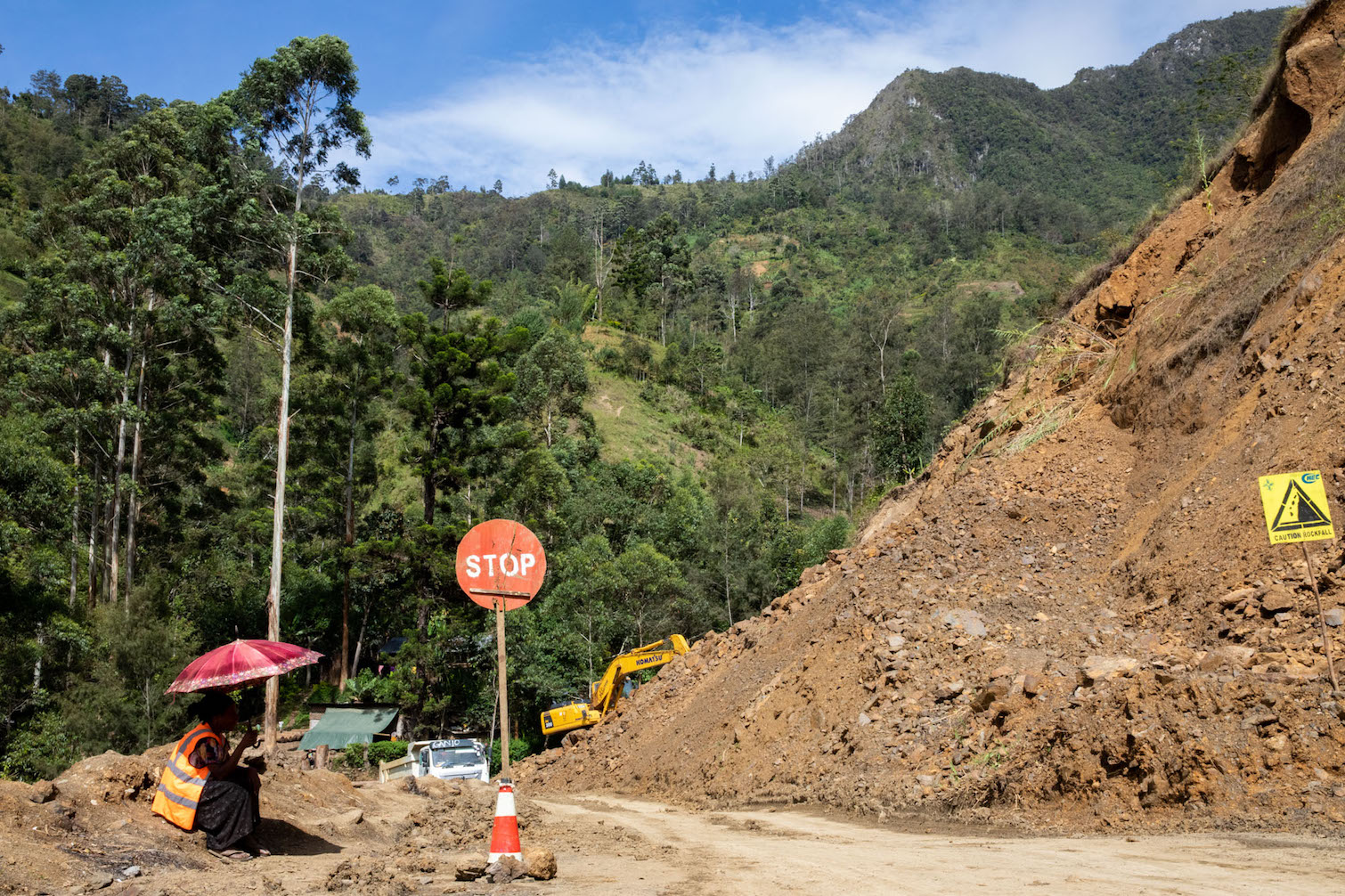
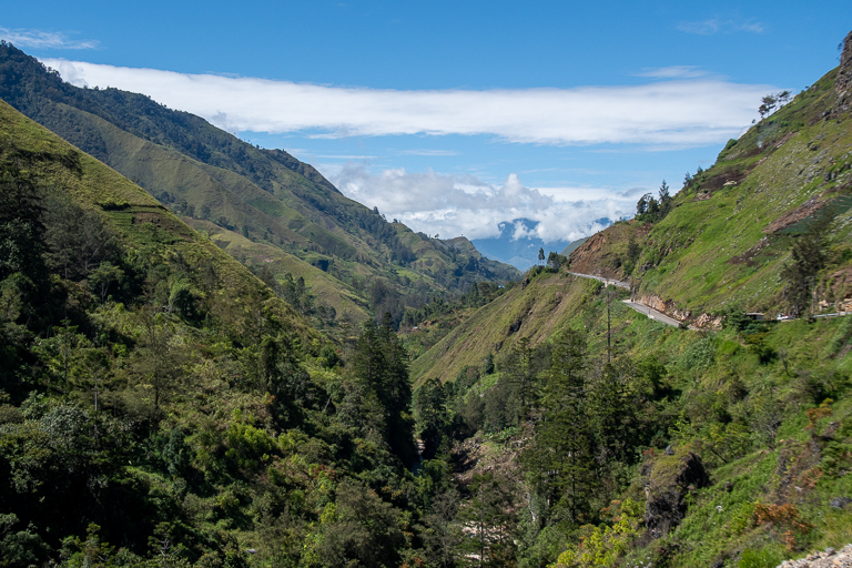
Two Mongabay reporters traveled the same stretch of newly upgraded road in the PNG highlands almost exactly a year apart. Contributor Camilo Mejia Giraldo traveled the roughly 29-km (18-mi) stretch from Kundiawa to Gembogl in October 2018, a year after work on the road commenced. Staff writer John Cannon made his trip in November 2019.
Mongabay spoke with Cannon and Mejia Giraldo to discuss what had changed, and what hadn’t, after a year of progress on the construction project.

The following interview has been edited for length and clarity.
Mongabay: Could you give us a brief overview of when you where there, what stretch of road you traveled, and via what means of transport?
Camilo Mejia Giraldo: I actually went the whole way from Goroka to Kundiawa and then up to Gembogl in a four-wheel-drive with someone with a driver, and it took about two hours from Kundiawa to Gembogl. Luckily, there hadn’t been much rain just before I got there. So there were two major landslides. One had been cleared, just, and the other one, the four-wheel drive sort of drove over it in a very precarious way. So, from that point it was obviously evident that there were a few issues with it.
John Cannon: My trip was in mid-November 2019. So 13 months after Camilo’s. And I, again, traveled the same length basically from Goroka to Gembogl. It was a pretty rainy time of year to be in the highlands. Rainy season just started, I think, that month. The road from Goroka to Kundiawa is not fantastic by any stretch, but it is paved. Once you get out of Goroka it’s pretty much lots of potholes and pockmarks from just the huge amount of rain and difficulty of maintaining that highway.
Once we left Kundiawa, it had been recently paved and the stretches we did travel on were relatively nice until we got to these landslide areas. That was a huge impediment to our traveling. It took us about three hours to get from Kundiawa to Gembogl, and a lot of that was waiting. At one of the landslides, we thought we’d try to wait and then push through with the four-wheel-drive vehicle that we were with. But then, five minutes after that first landslide, we hit another one that was clear was going to take hours to clear.
There was somebody running a little business, basically a little shuttle car between the last landslides — so we walked over four or five of these landslides and we took this little shuttle up to Gembogl.

So it sounds like the stretch of road that in 2018, about a year into the project, took about two hours to travel. You’re saying, John, that it took about three hours when you were there in 2019?
Mejia Giraldo: That’s interesting because, obviously, it was less complete when I was there, yet it was quicker. But obviously the rain has a big impact on it.
Cannon: Yeah, we hit these landslides and really, they were just impassable. We had a decent, late-model Toyota Land Cruiser that was outfitted for this sort of thing, but there were these 10-foot- or 12–foot-high [3-to-3.7-meter] landslides in front of us that were full of mud that would just swallow the car, basically. So yeah, it was quite an impediment.
It sounds like someone had already set up a little business shuttling people to and from the landslide, meaning this was not an unusual or unforeseen occurrence. Is that accurate, John?
Cannon: Yeah, absolutely. I think it’s something that the locals hope is sort of a temporary issue. They hope that, in some way, the company or the contractors that are in charge of building the road can shore up this constant landslide, that this won’t be a permanent thing. But yeah, they’re trying to make the best of it, I guess, and make the travel as efficient as possible.
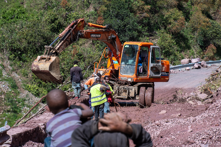
The interesting part was the day I left, it was relatively nice in the morning, sunny and pretty clear skies. We got up to the community where I stayed for the night, by about one in the afternoon. And then it rained for about the next 18 hours, I would say, until the next morning. And as we came back down, there were just a whole slew of new landslides that we had to walk over. That car that was running shuttles was no longer running shuttles because it really didn’t make much sense. We ended up just walking probably a total of about 5 or 6 kilometers [3 or 3.7 miles] from Gembogl to where we were able to once again pick up the car that we traveled in from Goroka. So even just overnight these landslides came in and were blocking the road.
I know you’ve both had a chance to review each other’s photos of the area. So, Camilo, was there anything surprising about John’s photos?
Mejia Giraldo: Obviously it was a lot more paved in John’s photos. But what struck me, what was surprising, was the similarities. Even the way the landslides look: the rubble, the rocks, the boulders in the road, and the presence of excavators as well. It’s basically almost the same photos in some parts.

And John, was there anything you found surprising, looking at earlier images of this area? Or was it also mostly just surprising in how similar it was?
Cannon: Yeah, it was it was amazing to see the similarities, just with a different surface on the road. It was interesting to see some of the heavy equipment in Camilo’s images, breaking rock off the side of the hillside. I don’t think we saw anything like that because that seems like more early-stage construction. But I remember picking up the bits of rock that had fallen in these landslides. Even the firmer pieces were this really crumbly rock. You could squeeze it in your hand and it would just kind of fall apart. That just reminded me of how, just, fragile in some ways these hillsides are when you start to cut into them like that. It’s hard to see that stopping I guess anytime soon.
And also looking at Camilo’s photos, I saw rocks encased in wire mesh and these relatively neat-looking rows of barriers that looked like they were sort of holding up the hillside. But in several places, the landside would just either tumble over that or just push that barrier right up to the downslope side of the road, just across the road and down.
I’m no construction expert, but it looked like a relatively effective measure to hold back the hillside. But when there’s enough rain, it’s really not that effective. It just kind of got pushed out of the way.

Camilo, when you were there 2018, I know you were reporting specifically on the road. What kinds of hopes, fears, frustrations, expectations were people in those communities expressing about the road and how they thought it might change their lives and their businesses?
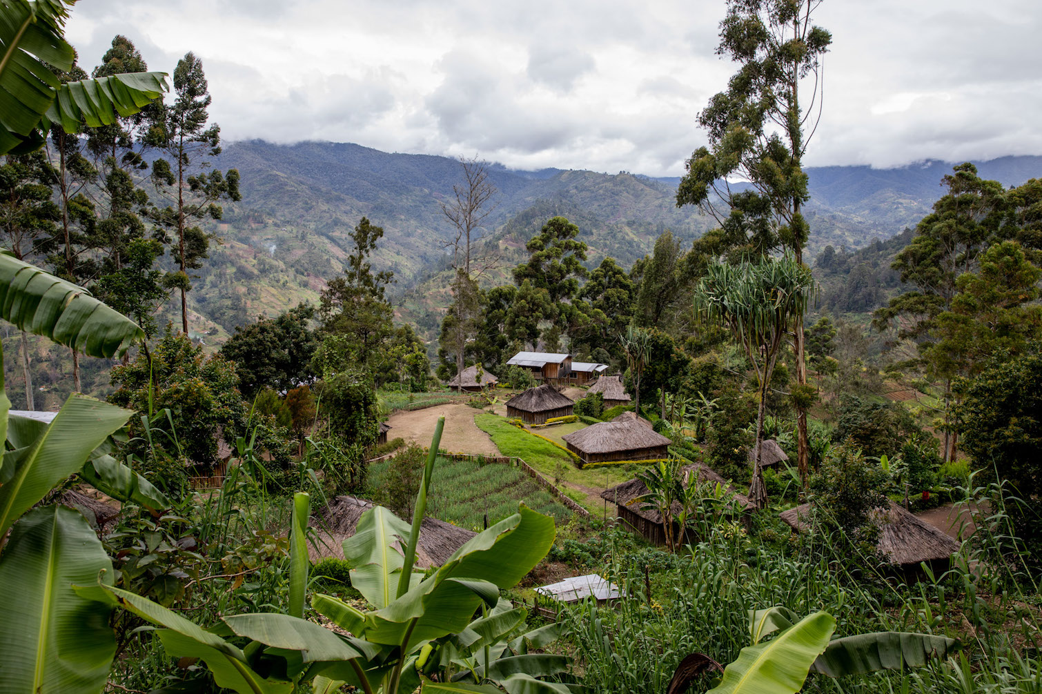
Mejia Giraldo: The general sentiment from the communities I spoke to in Gembogl and around was very positive. They focused a lot on the economic side of it. It would allow them to distribute their produce more quickly and safely to the big markets. And secondly, obviously, it would decrease travel times. Not just for general transport, but in emergencies. And also the links to government services, to hospitals and to schools. So they saw all those positives.
A local leader who I talked to focused on the increased flow of goods, but he also thought it would kick-start some local communities with some enterprising businesses. He said he thought people would start to plant different things, or they would start tourism businesses, things like that. So, for him, it was a very important piece of road in that way.
So what they were focusing on was the overall lifting of living standards, with the road coming in.
As far as the fears that they focused on: A lot of people didn’t really have any. They would sit down and they would think about it a bit more when I would talk to them. But people did say, “Look, it is something we have to talk about. Because along with the positive things, there’s always going to be negative things happening in the area.” With PNG being such a tribal system still at the moment, a lot of people were concerned about possible influxes of people coming in from urban areas. Not even foreigners, what they said was people from PNG that weren’t of the same culture. There can be tensions, social tensions, that can come up from that.
And because the road has the potential to be built from Gembogl straight to Madang, which is the province to the north, that would increase traffic an incredible amount. Because Madang has quite a few people and industries, like logging and some minor fishing. And people thought maybe that would bring some issues. HIV has a big stigma there, and a government official mentioned to me that he’d been told of certain people in the community saying that foreigners or other people from PNG might come in with this road to take up the opportunities that it might bring, and bring things like HIV into the community.
I had spoken to officials in other provinces that had been quite critical of the government in regards to road maintenance and everything like that, and I brought that up in Gembogl. And the person I spoke to there, he wasn’t as critical. He said, look, in regards to landslides in particular, they were looking at planting trees along the road as a solution to it. But he didn’t really go into much more detail than that.
John when you traveled through a year later, were there any similarities and any differences in the kinds of things you were hearing people at that time saying about the road?
Cannon: I think in general there’s still a pretty high level of enthusiasm for the road. To have seen it paved, I think was a big step. There’s a certain standard of living that having a paved road through your community seems to bring. I think people take some pride in that, even if it’s not always passable.
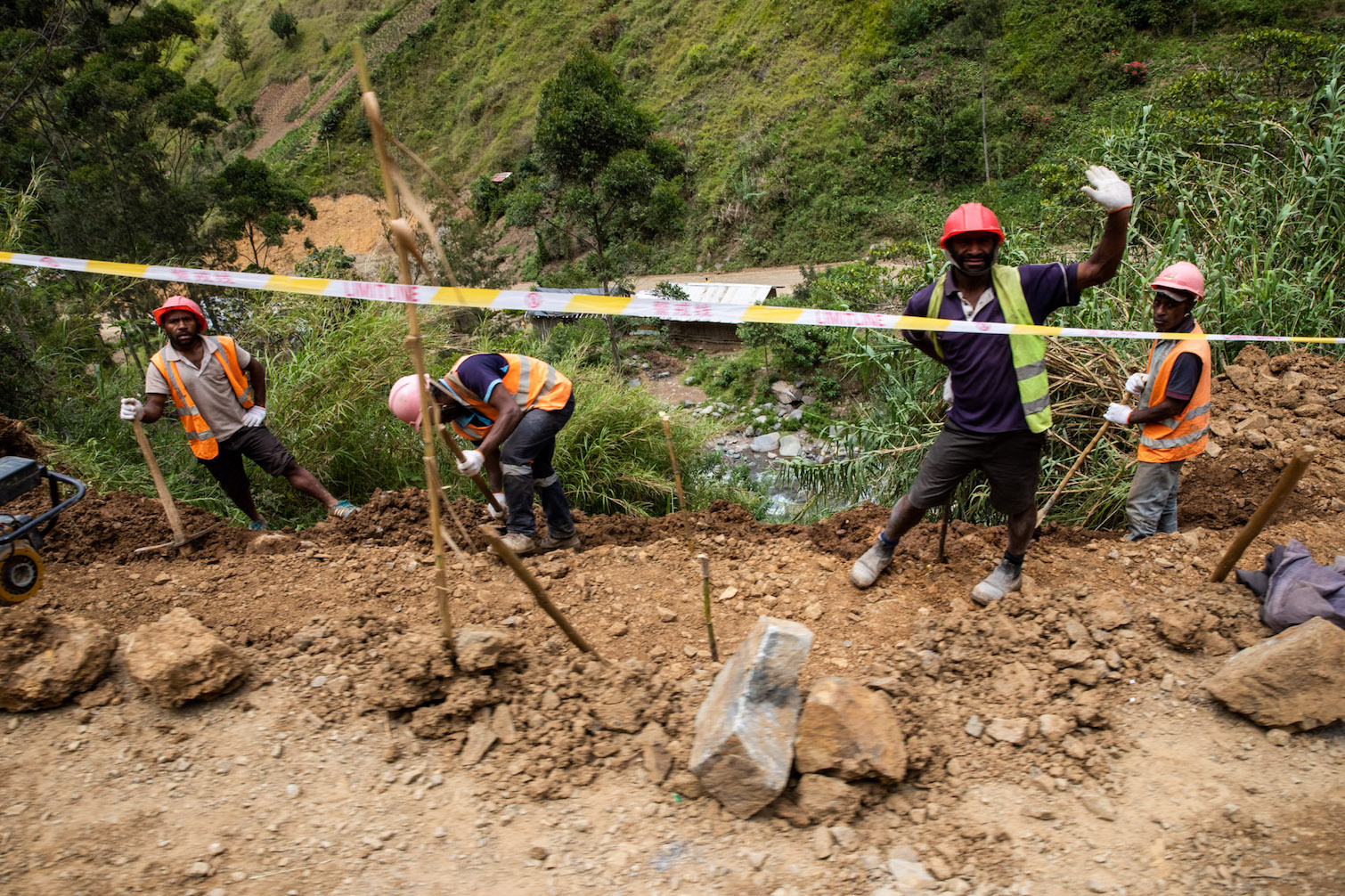
And, to be honest, even the jobs created by having to move the landslides — I mean, it’s not a huge number of people, but you have 10 to 15 people, usually men, on a crew helping to move rocks and dirt and debris from the road, as well as some jobs for the women directing traffic and that sort of thing. In a place that’s really cash poor, in a lot of ways, that was seen as a benefit for a lot of the folks I spoke with.
I didn’t get the sense from conversations that people were really pessimistic. I think they were willing to sort of wait and see what happened, what sort of fixes would come along.
I mean, obviously, they realize that having these constant landsides is not really a sustainable situation.
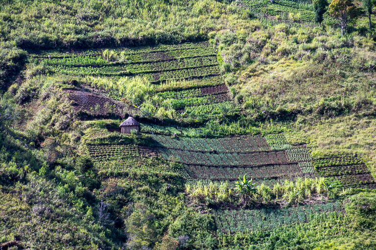
From the local economy perspective, bulb onion is one of the biggest crops in the area and you see it on every hillside, just these impossibly steep fields where people farm these bulb onions. To turn that into profit they have to get that to market, right? So that goes along with everything Camilo was saying about connecting these further-flung communities. This crop, it’s heavy, it’s bulky, it’s difficult to transport. You can transport a huge bag on someone’s back, but that takes a lot of people, it takes a lot of time. So getting cars flowing through this area in either direction, whether it’s to Kundiawa or to Madang, they see that as a huge boon for their local economy.
Did you personally have a sense that those expectations were realistic? That the standard of living would improve just by having a paved road? That this was going to be something that, despite some setbacks, still made life a lot easier for people needing to move themselves or their goods to urban centers?
Cannon: I would imagine that it would maybe provide some incremental benefit. I think, just having that option as a way to get your produce to market or, as Camilo was saying, getting to health care or to schools.
It’s hard to predict and it’s hard to measure how that will turn out. But my sense is that it would probably improve marginally. It’s hard to say really beyond that.
And there’s also just being connected to the rest of the country. PNG as a whole has such a small network of roads, in large part because these [are] geographically challenging areas to build infrastructure. And to be connected to centers of commerce and centers of government where decisions are made. Again, it’s one of those things that’s really hard to measure, but you could see that could provide some benefit, down the road: giving people voice and in their futures and that sort of thing, if that makes sense.

One of the things I know that researchers are really looking into right now when they’re talking about road projects, especially tropical road projects, is finding places where, on balance, a road is beneficial. Where ecological risks are relatively low, and potential benefits are high. How do you feel the balance stacks up in this particular case?
Mejia Giraldo: This one is, I guess, a road upgrade. The district road had been there for a bit so this is a pretty serious upgrade of the road. There’s already quite a bit of population around there. A lot of the land is farmed already. But around Gembogl and beyond, there is quite a bit of what they call “bush” there, which is untouched forest. It’s quite environmentally important. And with any road, there’s always a risk of having extractive industries have easier to access to it. Bear in mind that it’s still quite rough terrain up around this, so they’d have to build yet another sort of access road, like a logging road, for example, if that were the case.
Speaking to some community leaders about things like mining and logging impacts in the future, they did raise it as a concern, but also as an opportunity. They said, “Look, we would have to all agree on how that would look.” So, I still feel like for a lot of people there, the road does bring those possible environmental impacts in the future, and not everybody would be against it. But, then there are some people that are thinking about those possibilities, and doing it in the most sustainable way possible.
OK, thank you. I just wanted to see, starting with John, if you had any final thoughts about what you saw while you were traveling, or about what you heard?
Cannon: Just to kind of wrap things up, in some ways, looking at the paving and the structures they put in place, there was some thought that went into this. But I’m not sure it was enough to really cope with the amount of rains, just the severity of the local landscape in so many ways. It just strikes me as a bit tragic to have these communities that really are putting so much hope in what they see as a solution for their economic livelihoods, to better their standard of living, to have that thwarted by something that seems a rather intractable problem.
These landslides have become such a problem just in the year that it’s been paved and put into use. Again, this is not a huge road. This is not a massive highway by any stretch. It’s a narrow, two-lane road that won’t likely have the capacity to take enormous amounts of traffic. But even the small amount of traffic on it is constantly impeded by these problems that crop up, and that will be a maintenance problem, I think, for the lifetime of that road.
Roads are something that in Papua New Guinea are seen as really important to bring the country together. Because you have so many disparate groups that are literally cut off from each other, and cut off from the leaders who make so many decisions that affect their lives. To really be forced to fly on relatively expensive flights when you want to make your voice heard is really difficult for a lot of people.
It strikes me as an issue that’s not going to go away anytime soon. And then I’m not optimistic about the benefits that will eventually come to local communities in this area.
Camilo, any final thoughts?
Mejia Giraldo: It’s hard to say, down the road, how this will play out.
It is a very important road for these communities. And I think in the future, it depends on the PNG government, which at the moment is going through a medium-term development plan where they want to really extend the road network, to pretty much connect the whole country.
And this road in particular, did have some thought put into it, like John said.
Even in some of the reports, they do say, “Look, climate change will affect rainfall. It’s expected to increase by X amount by 2055, the slopes will be increased.” So they had thought, “We’ll make additional corrections to the road, we’ll design drainage systems.”
But even then, it’s sometimes hard with these really difficult terrains. I mean, the road goes next to pretty much vertical mountainsides in some cases. It would be hard for a first-world country to even maintain a road like this.
So one would hope that it would actually bring a bit of benefit to their communities. But it is hard in a country like PNG, when the government has these big plans — it’s hard, for myself, to put a perspective on it. But it seems that they’re focusing more on expanding roads rather than focusing on the ones they already have and really ensuring that they’re maintained properly. And then, when they do have the funding, connecting more and more communities in a more sustainable way. But this one, yeah, it’ll be interesting to see what actually happens in the future with it.
We’ve just been focusing on this single road project in this discussion, but it sounds like this road is perhaps a microcosm of the larger issues facing road construction in PNG as a whole. Do you think that’s accurate, that some of the issues with this project are going to be similar across the country, or at least across the highlands?
Mejia Giraldo: Yeah, I think it is. Maybe less so on the environmental impact side, because some of the roads that they want to build through PNG to link other centers do cut through basically untouched areas. So the environmental impact on ecosystems would be quite large.
But yeah, with this road, you can see the community hope, the economic aspects, the social aspects, and the political side as well because it is put on a lot of banners and news and everything like that by the government. That, “Look, we are connecting the country. This is our step forward.” And if they do manage to maintain these roads through until the economy picks up, then things will be good. But there just seem to be too many variables that will make it hard, for this road in particular, to just be maintained, or even redesigned, to avoid five-hour trips and constant landslides.

FEEDBACK: Use this form to send a message to the author of this post. If you want to post a public comment, you can do that at the bottom of the page.