- Activists have criticized a draft zoning plan for coastal areas in East Kalimantan province meant to help resolve territorial disputes between local communities and business interests.
- They contend the plan instead benefits the coal, oil and gas, and plantations industries at the expense of fishing communities.
- Among its provisions are generous concessions for coal and oil and gas infrastructure that would require land reclamation in coastal waters currently used by traditional and small-scale fishers.
- The plan also calls for resettling nearly 140,000 households from displaced fishing communities onto an area of land smaller than 50 football fields.
JAKARTA — Environmental activists in Indonesia have slammed a proposed zoning plan for coastal areas in eastern Borneo that they say will hurt the livelihoods of local fishing communities in favor of the extractives and plantation industries.
The government of the province of East Kalimantan has for the past few years been drafting the plan, referred to as RZWP3K, with an eye to resolving land disputes in coastal areas and small islands. These conflicts typically pit local communities against mining, agriculture and tourism businesses, and part of the plan is to designate areas for fishing grounds, conservation and other maritime purposes.
But the latest draft of the plan, presented at a public hearing on Nov. 27, drew criticism from the People’s Alliance for Maritime Justice, a coalition of environmental NGOs.
“The zoning plan for East Kalimantan must be rejected because it isn’t drafted for the interests of the people, particularly that of the fishermen,” Seny Sebastian, from the Mining Advocacy Network (Jatam), one of the NGOs in the alliance, said in a statement.
The group’s key objections are that the plan, as it stands, would unfairly benefit the coal and oil and gas industries; allow reclamation activities by property developers; and permit the building of infrastructure for large-scale logging and plantation activities.

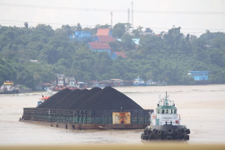
In particular, the alliance says the draft plan calls for the development of roads and oil refineries across 752,180 hectares (1.86 million acres) of land in the two coastal cities of Bontang and Balikpapan, Indonesia’s oil hub. That development would involve reclamation activities in waters currently used by local fishing communities, the group says.
The draft also allocates 46,758 hectares (115,542 acres) of land in coastal areas and small islands for oil and gas production, and 1.3 million hectares (3.2 million acres) of the province’s 3.7-million-hectare (9.1-million-acre) maritime zone for offshore drilling. More than half of that offshore area, or 719,000 hectares (1.78 million acres), constitutes the fishing grounds of local fishers, according to the alliance.
On the coast, the alliance says the draft would allow mining on 65,460 hectares (161,755 acres) of karst landscape. It would also permit the construction of port terminals specifically for coal, oil and gas. Under the draft, these terminals would overlap into two protected areas — Apar Bay Nature Reserve and Adang Bay Nature Reserve — and the ecosystem of Balikpapan Bay.
East Kalimantan is already Indonesia’s coal-mining heartland, with an estimated 28 percent of the country’s reserves of the fossil fuel. More than half of the province’s total land area has been allocated for mining concessions. Balikpapan, the province’s biggest city, is home to oil and gas refineries and a busy seaport, while Kutai Kertanegara district, further inland, is Indonesia’s biggest coal producer.
At the same time, the activists say, the zoning plan offers little in the way of assistance for the provinces fisheries sector, made up largely by traditional and small-scale fishers. It allocates just 25 hectares (62 acres) of land — an area smaller than 50 football fields — to resettle nearly 140,000 households from displaced fishing communities.
The plan would also designate an area of 2.6 million hectares (6.4 million acres) for fishing, but activists say this proposed zone is farther out to sea than traditional and small-scale fishers can reasonably reach.
“This means that they will have to compete with big vessels carrying coal,” Seny added.
Similar zoning plans elsewhere across Indonesia have also been criticized by activists, who say they end up discriminating against coastal communities. In Sumatra’s Riau Islands province, a reclamation project prescribed in the local zoning plan sparked a corruption investigation earlier this year in which the provincial governor was arrested.
Activists have called on local governments to suspend the adoption of zoning plans and review those already passed into bylaws. East Kalimantan is one of 13 provinces in Indonesia, alongside the capital, Jakarta, still drafting their respective plans. Twenty-one other provinces have passed their plans into bylaws as of June this year.
“The RZWP3K is supposed to give positive impacts,” said Susan Herawati, secretary-general of the People’s Coalition for Fisheries Justice. “Coastal communities are supposed to be the main actor in the development of coastal areas and small islands.”

FEEDBACK: Use this form to send a message to the author of this post. If you want to post a public comment, you can do that at the bottom of the page.