
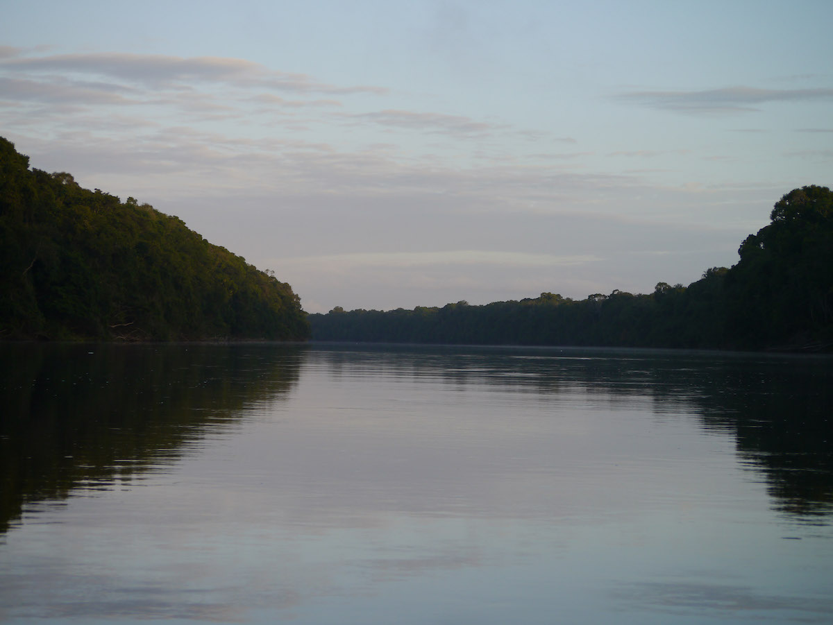
- The South American country of Guyana is one of a handful of high-forest/low-deforestation countries, with around 85 percent of its biodiverse rainforest still intact.
- In 2010, Guyana entered into a partnership with Norway, which agreed to pay the heavily forested country $250 million if it kept deforestation low for five years. The project was part of a scheme called “reducing emissions from deforestation and forest degradation” (REDD+), which aims to curtail global warming by channeling funds from wealthy countries to tropical forest countries in exchange for lowering their deforestation rates.
- Guyana’s REDD+ project has been lauded as a success, with rates of forest loss between 2011 and 2015 registering below a 2010 benchmark. However, a new study analyzed satellite data between 2000 and 2017, finding tree cover loss more than doubled after Norway’s payments ended in 2015. The study’s authors say their findings point to a need for continuous forest protection payments.
- But Guyana’s government says the country’s higher levels of tree cover loss in 2016 and 2017 revealed in the study were likely due to tree death from El Nino climate events and not active deforestation. When the Guyana Forestry Commission conducted its own analysis using another, higher-resolution satellite dataset, it found instead that deforestation remained low in 2016 and 2017. Both datasets agree that deforestation stayed low in 2018.
A landmark five-year, $250-million pay-for-performance agreement between wealthy, oil-rich Norway and heavily forested Guyana was supposed to keep the South American nation’s biodiverse and carbon-rich forests standing and their carbon out of the atmosphere.
The scheme worked for a while, say the authors of a study published last week in the Proceedings of the National Academy of Sciences. Tree loss during the five-year program period was substantially less than what it would have been without the payments, the paper’s authors report, resulting in millions of tons of avoided carbon emissions. But they found that once the money stopped flowing, tree loss spiked. The more recent numbers, however, contradict official statistics produced by the Guyana Forestry Commission (GFC).
Guyana, a nearly Britain-sized nation on South America’s northern coast, has largely resisted the forces that have consumed much of the Amazon and Southeast Asian rainforests. More than 85 percent of its original forest remains intact, making it one of a handful of high-forest/low-deforestation countries.
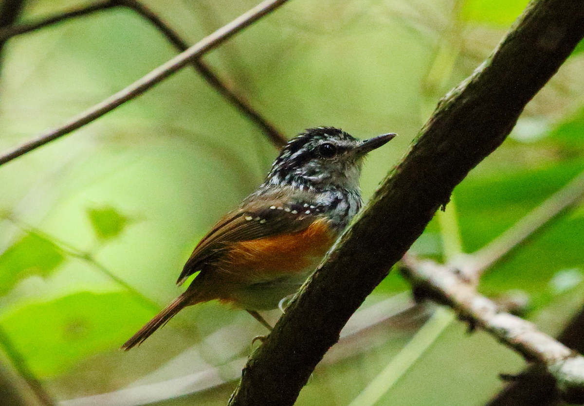
Keeping it that way is critical, say conservationists and environmentalists. The continuous forest of the Guyana shield, which includes much of Guyana and neighboring Suriname, pulls in moisture from the Atlantic Ocean and supplies water to the Amazon, regulating the regional climate. Guyanese forests are also exceptionally diverse, harboring more than 1,200 amphibian, reptile, bird and mammal species.
In 2009, Norway and Guyana announced a deal: Norway would pay Guyana for keeping its annual forest loss near or below a 2010 baseline of 0.056 percent, with decreasing payments as deforestation approached 0.1 percent annually, and no payments above that threshold.
The program was hailed as a model for a concept called “reducing emissions from deforestation and forest degradation,” or REDD+, which had recently emerged from global climate negotiations as a means to hold down greenhouse gas levels by keeping carbon stored in tropical forests. The requirement that Guyana meet annual forest conservation targets in order to receive money was especially novel, says Tim Laing, an economist at the University of Brighton in the United Kingdom who has studied the program. “If Guyana didn’t perform, theoretically, it was not going to get paid. That was really quite groundbreaking at the time.”
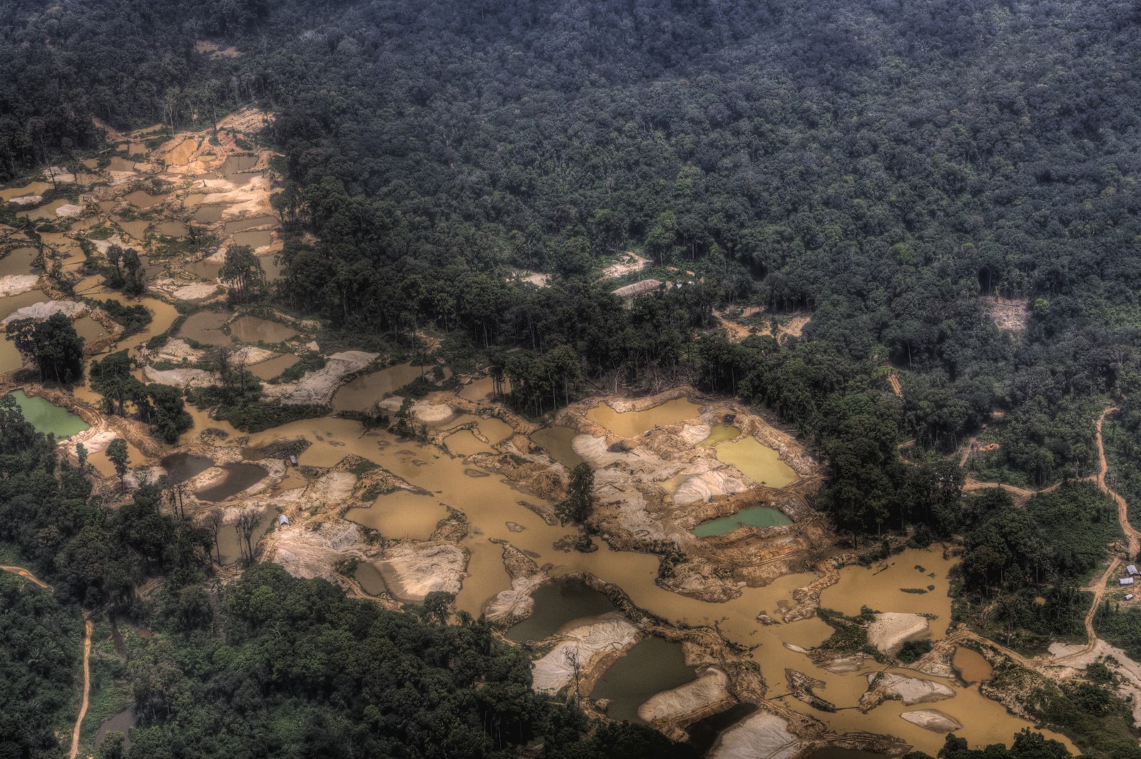
Norway first funded Guyana to build the capacity to monitor its own forests using high-resolution satellite and airplane imagery and attribute it to on-the-ground drivers such as mining, farming and development. The system made clear that small-scale gold mining accounts for more than four-fifths of Guyana’s deforestation, says Pradeepa Bholanath, head of planning and development for the Guyana Forestry Commission.
“It’s really been a pretty incredible piece of work that Guyana went from a country with relatively low capacity to a country that’s very impressive on a global scale,” says Timothy Pearson, a carbon accounting specialist at Winrock International in Arlington, Virginia, who consulted on the project.
With the system in place, the forestry commission began tracking annual forest change. Norway also conducted its own assessments to verify Guyana’s numbers before making payments.
To assess whether those payments actually helped conserve the forest, Anand Roopsind, a conservation scientist at Boise State University in Idaho who is originally from Guyana, and colleagues used 30-meter resolution satellite data collated by researchers at the University of Maryland (UMD), which is derived mainly from the U.S.’s Landsat satellites, to track tree cover loss from 2000 to 2017. The researchers also used a computer model to construct a “synthetic Guyana” that didn’t benefit from a REDD+ program. They used forest gain and loss from several other high-forest/low-deforestation countries, including Suriname and Gabon in central Africa, as well as factors such as mining profits and agriculture and population statistics, to simulate a Guyana that received no payments.
The method “represents a huge improvement in our field in terms of quantitatively and objectively finding appropriate comparisons,” Roopsind says.
Guyana’s REDD+ program came at a precarious time for South American forests. The price of gold on the international market spiked following the Great Recession, and gold mining exploded throughout the Amazon.
In real Guyana, despite the increased pressure, deforestation from 2010 to 2015 held more or less steady. In synthetic Guyana, it shot upwards by 30 percent. Over the five-year period, the REDD+ program resulted in 12.8 million tons of carbon remaining in trees and not being emitted, Roopsind and his colleagues concluded.
“It’s basically like removing almost 2.5 million cars from the streets,” Roopsind says.
But according to the study, the gains were short-lived. Once payments ended, tree cover loss in Guyana more than doubled, surpassing synthetic Guyana in 2016, says Roopsind. While he cannot say exactly why, he suspects the lack of continuing payments from Norway was a factor. “We need stronger clauses in the agreement for permanent protection” of forests, he says.
Laing hails the study as “a really fantastic approach” for comparing the REDD+ intervention to a business-as-usual scenario. But he notes that it’s not clear how well Roopsind’s synthetic Guyana captured the factors that actually drove forest loss—a challenge faced by all so-called “counterfactual” scenarios designed to simulate something that didn’t actually happen, Laing notes. For example, modern techniques allow miners to extract more gold while clearing less forest, to some extent decoupling forest loss from mining profits.
Additionally, Laing says, it’s not clear why the REDD+ program would have driven down deforestation, since little money was actually spent within Guyana during the payment period. In a 2018 paper, Laing argued that few payments were made to indigenous communities that control about 15 percent of Guyana’s land, and a hydroelectric power project that was to be partially funded by the program was delayed and eventually scuttled. That money will soon be disbursed to other green development projects, which will complete Norway’s payments under the agreement, Sveinung Rotevatn, State Secretary at Norway’s Ministry of Climate and Environment, wrote in an email.
Bholanath says her team’s statistics confirm that deforestation remained under control from 2010 to 2015, as Roopsind’s team found. But she disputes that it spiked afterward. Instead, she says, the rate has gone down. For 2018, it was 0.051 percent, according to statistics that the Guyana Forestry Commission released today. UMD statistics for 2018 also show tree cover loss on par with years prior to 2016.

The main reason for the discrepancy, Bholanath believes, is that her team tracks forest change using European Sentinel-2 satellites with 10-meter resolution, along with even higher-resolution commercial satellite and airplane imagery. The sharper view allows her to better quantify and classify the small patches of tree loss that accompany artisanal gold mining and other sources, some of which are not linked to permanent land-use change, she says. “It really makes a big difference.”
UMD data do not distinguish between natural tree loss from storms and human-caused deforestation, Bholanath adds. A spokesperson for Norway’s Ministry of Climate and Environment noted that a powerful El Niño culminating in 2016 hammered forests throughout South America, likely contributing to Guyana’s tree loss spike that year.
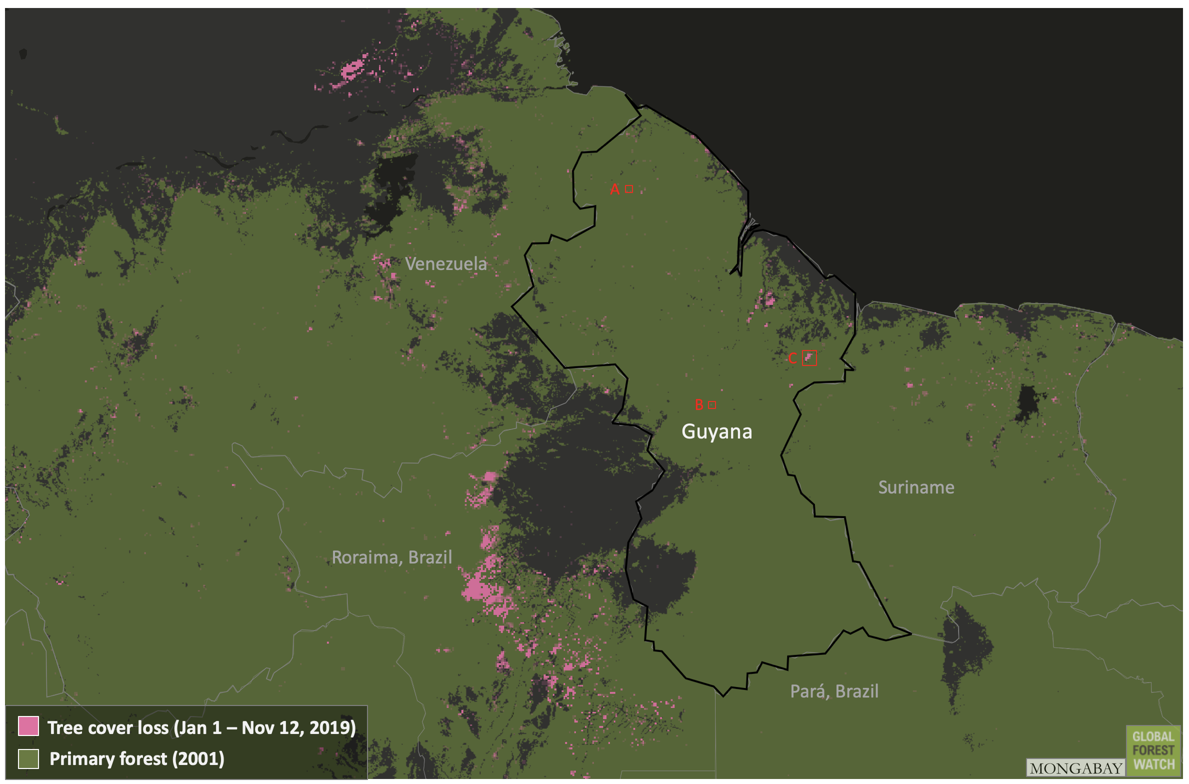
UMD data from 2019 show numerous patches of tree loss around the town of Linden and a couple larger cleared areas in eastern Guyana. Roopsind suspects bauxite mining as a driver, but Bholanath counters that the UMD algorithm may have misclassified clouds or light soils as forest loss. However, satellite imagery from Planet Labs and data from NASA indicate this specific area of deforestation was caused by fires that ripped through the area in April and May. The images also reveal several areas where mining operations appear to be expanding and cutting into the surrounding forest.
UMD data hint that tree cover loss this year may be eclipsing 2018’s numbers. Regardless, Guyana’s forest loss remains far lower than in neighboring Brazil and elsewhere in the Amazon, and the country was unaffected by the August fires that gained international attention.


Differences between countries’ annual statistics and UMD data are common, says Peter Ellis, a forest carbon scientist at The Nature Conservancy in Arlington, Virginia. But he adds that that doesn’t necessarily mean the national figures are more accurate.
Roopsind stands by his numbers but notes a different limitation of his study: He and his colleagues did not find a satisfactory way to determine how much (if at all) deforestation may have increased in Suriname as a result of Guyana’s progress, a phenomenon known as leakage. “The issue of leakage is definitely something we need to explore more,” he says. He thinks a regional REDD+ effort covering the entire Guyana shield could help.
Despite the uncertainties, Norway, the program funder, is satisfied. “Deforestation remains extremely low,” wrote Rotevatn. “Progress has been made on integrated land-use planning and management, and Guyana has also made important improvements in measuring and reporting on the state of their forests. As with any partnership, there are weaknesses and room for improvement.”
Most importantly, says Bholanath, Guyana is now ready for whatever REDD+ evolves into in the future. Hopes for a global fund that rich countries would pay into have given way to more of a piecemeal system in which individuals, companies, NGOs and states wanting to offset carbon emission or fund forest protection can donate to tropical countries that are capable of transparently and credibly tracking their forest.
“We have now, after eight years of doing this work, an operational system that sustains itself,” Bholanath says. “Our role is to enable the technical systems to fulfill whatever will come our way.”
Banner image by Marco Farouk Basir via Wikimedia Commons (CC BY-SA 3.0).
Editor’s note: This story was powered by Places to Watch, a Global Forest Watch (GFW) initiative designed to quickly identify concerning forest loss around the world and catalyze further investigation of these areas. Places to Watch draws on a combination of near-real-time satellite data, automated algorithms and field intelligence to identify new areas on a monthly basis. In partnership with Mongabay, GFW is supporting data-driven journalism by providing data and maps generated by Places to Watch. Mongabay maintains complete editorial independence over the stories reported using this data.
Feedback: Use this form to send a message to the editor of this post. If you want to post a public comment, you can do that at the bottom of the page.