- The fires raging in the Amazon are nearly double over last year, but remain moderate in the historical context.
- The 41,858 fires recorded in the Amazon as of Aug. 24 this year are the highest number since 2010, when 58,476 were recorded by the end of August. But 2019 is well below the mid-2000s, when deforestation rates were very much higher.
- However, this year’s numbers come with an important caveat: the satellites used for hotspot tracking in Brazil have limited capacity to detect sub-canopy fires.
- The hazy, dark skies over São Paulo have focused worldwide attention on the soaring deforestation rates in the Amazon as well as the pro-deforestation policies of President Jair Bolsonaro.
While fires burning in the Amazon have garnered worldwide attention due to last week’s midday “blackout” in urban São Paulo, more than 2,500 kilometers (1,550 miles) from the Amazon, analysis of historical data suggests the fires are well within the historical range of the past 20 years.
Mongabay’s analysis of data from Brazil’s National Space Research Institute (INPE) shows that the number of fire hotspots recorded this year in the Amazon biome total 41,858 through Aug. 24, an increase of 89 percent over the end of August 2018, with still a week to go in in the month. (If August keeps its current pace, Amazônia will tally nearly 50,000 fires by the end of the month.)

The 41,858 fires recorded so far this year in the Brazilian Amazon are the highest number since 2010, when 58,476 were recorded by the end of August. But 2019 is well below the mid-2000s, when fire hotspots regularly topped 60,000 through this point in the year. Over the past 20 years, 2005 — a year of severe El Niño-induced drought — holds the record of 94,780 fires through August. 2019 currently stands roughly 4 percent above the 20-year average and is on pace to end the month at around 50,000 fires, or 19 percent above average.


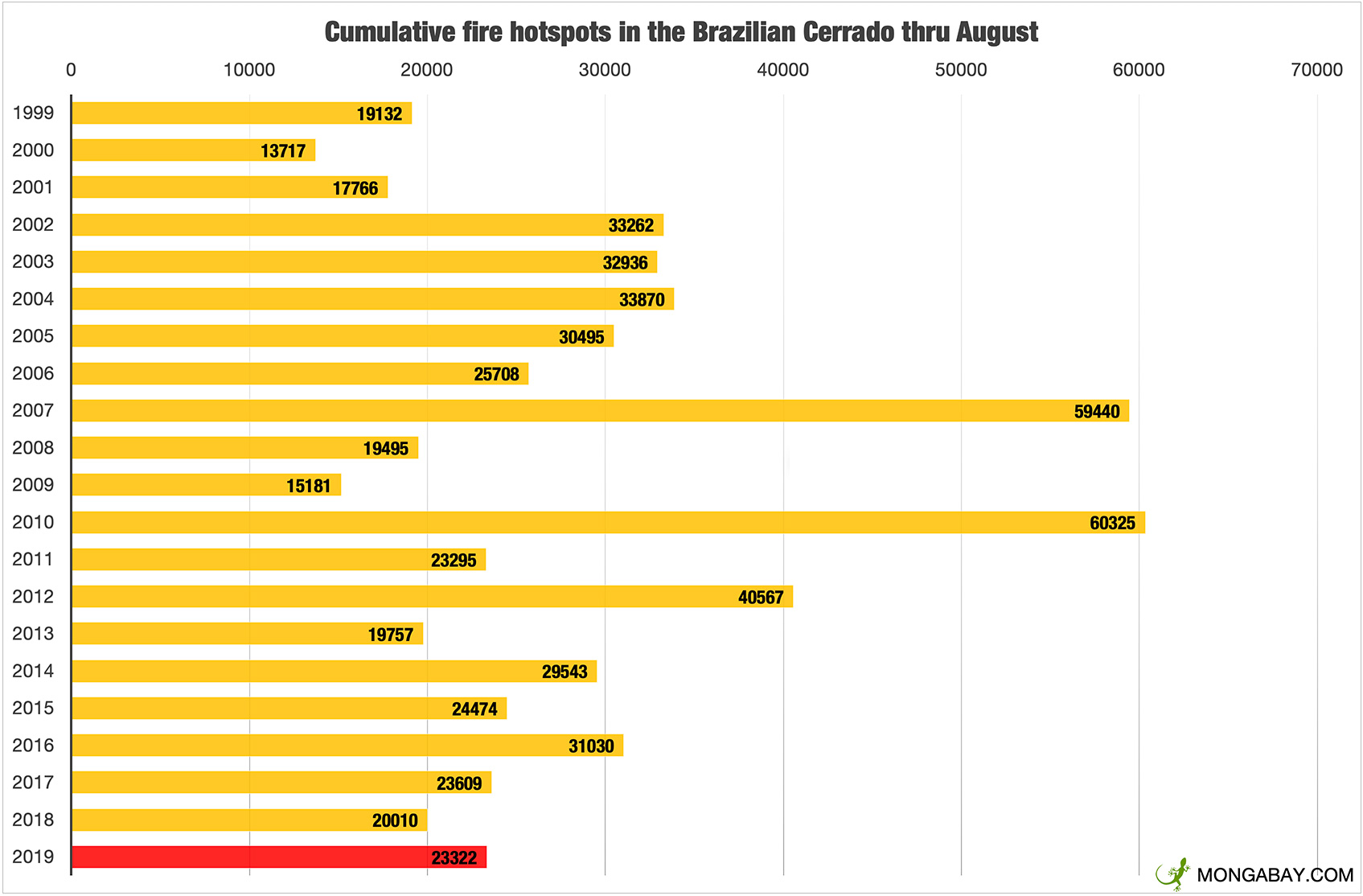
The situation is similar in the Cerrado, a woody, savanna-like biome that lies east and south of the Amazon. Through Aug. 24, 23,322 fires had been recorded there, which is slightly less than the 20-year average for this point in the year.

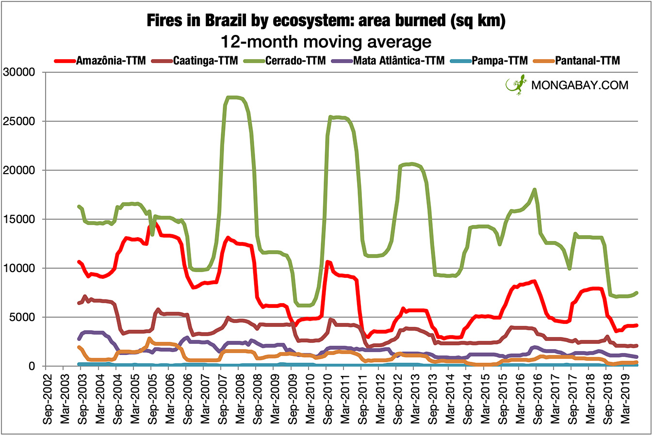
In terms of the extent of burning, INPE releases data on a monthly basis, so Mongabay could only look at numbers through the end of July, before the recent surge in fires. With 18,629 square kilometers (7,193 square miles) burned through July in Amazônia, 2019 was 62 percent higher than 2018, but below the 2016 figure.


An important caveat
These numbers come with an important caveat: the satellites used for hotspot tracking in Brazil have limited capacity to detect sub-canopy fires. This is a significant limitation because the area affected by sub-canopy fires that burn into intact and otherwise healthy forests can be quite substantial: a 2013 NASA study published in the journal Philosophical Transactions of the Royal Society B found that understory fires burn a larger extent of forest than the area deforested for agriculture and cattle pasture.
And these fires do long-term damage to the rainforest, setting the stage for more destructive fires, forest die-off, and eventual deforestation. Long-running research initiated by scientist Daniel Nepstad when he worked at the Woods Hole Research Institute, found that forests that have previously been burned are twice as likely to be deforested as unburned forests.
Nepstad, now the head of the Earth Innovation Institute, explained the context of the current situation in a blog post.
“Satellites do NOT detect most fires that are burning beneath the canopy of standing forests. And it is these low fires, that rarely reach the knee, that do the most damage, burning slowly across the forest floor, killing giant trees with thin bark,” he writes. “Once these trees die, they fall to the ground, opening up huge gaps in the forest canopy that allow more sunlight to reach the forest floor, drying the fuel layer and making the forest more prone to further burning.”


Nepstad notes that we don’t yet have a good understanding of the damage from the current burning season, but there is plenty to worry about based on preliminary evidence. For example, the fires are more persistent than in recent years, indicating that they are burning hotter, meaning they are burning more than pasture and dry scrub. And there’s lots of smoke.
“We do not know with confidence how the area of fire compares with previous years, [but] it is important to bear in mind that the fire season has just begun, with most fires occurring from September to December,” he writes. “With forecasts of a long dry season, the number of fires could continue to be greater than usual.
“We also know that it is a particularly smoky burning season. This is probably related to the large number of ‘deforestation fires’ — fires set to burn patches of forest that have been felled to make way for cattle pasture or crop fields. The smoke released from a fire that burns a hectare of felled forest releases far more smoke than a fire that burns a hectare of degraded pastureland. We do not know the area of standing forest that has burned. Forest fires, however, usually happen late in the dry season.”


While the current fires aren’t off the charts relative to the historical baseline, they are indeed concerning. But the silver lining to the crisis is that the hazy, dark skies over São Paulo have sparked worldwide attention to the soaring deforestation rates now occurring in the Amazon, as well as the pro-deforestation policies of President Jair Bolsonaro. High-level political blowback from the EU, street protests, and pressure on Brazilian companies has forced Bolsonaro to backtrack on some of his most heated rhetoric from the past week and start to take action, including sending in the army to battle fires. Volunteer fire brigades formed by landowners, indigenous peoples and NGOs have already been battling the fires for weeks.
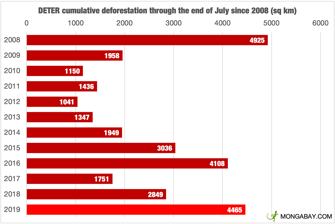
According to INPE, deforestation in 2019 in the Brazilian is trending 57 percent ahead of last year through the end of July, the fastest rate of deforestation since 2008. Deforestation appears to be continuing at a high rate through August, but the picture is less transparent than usual because INPE has stopped releasing data publicly since Bolsonaro fired Ricardo Magnus Osório Galvão, the head of the agency, at the beginning of the month.
