
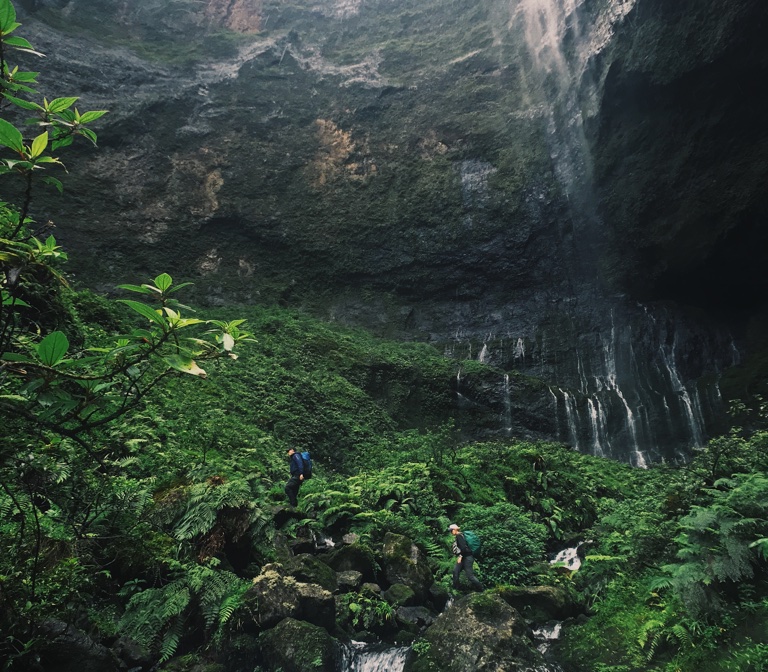
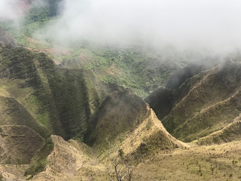
- For decades, botanists at the National Tropical Botanical Garden (NTBG) in Hawaii have rappelled down dangerously steep cliff faces using ropes, hung out of helicopters and walked through some very remote valleys to look for, and conserve, rare, native plants. Several cliffs and valleys, however, have remained inaccessible.
- Drones are now helping the NTBG staff access and survey some of these difficult-to-reach parts of the Hawaiian islands.
- Mongabay recently spoke with Ben Nyberg, a GIS coordinator and drone specialist at NTBG, about the use of drones for plant conservation.
Sometimes looking for rare plants can mean taking extreme steps. And for decades, botanists at the National Tropical Botanical Garden (NTBG), a nonprofit based on the island of Kauaʻi in Hawaii, have done that. They’ve rappelled down dangerously steep cliff faces using ropes, hung out of helicopters and walked through some very remote valleys — all in an effort to search for Hawaii’s rare native plants, and find ways to conserve them. Still, several remote, rugged cliffs and valleys have remained out of reach until recently. Thanks to drones, that’s changing.
Nearly two and a half years ago, Ben Nyberg, a geographic information systems (GIS) coordinator and drone specialist at the NTBG, started exploring the potential of some of the commercially available drones in surveying difficult-to-reach habitats in Kauaʻi. And his efforts are already paying off.
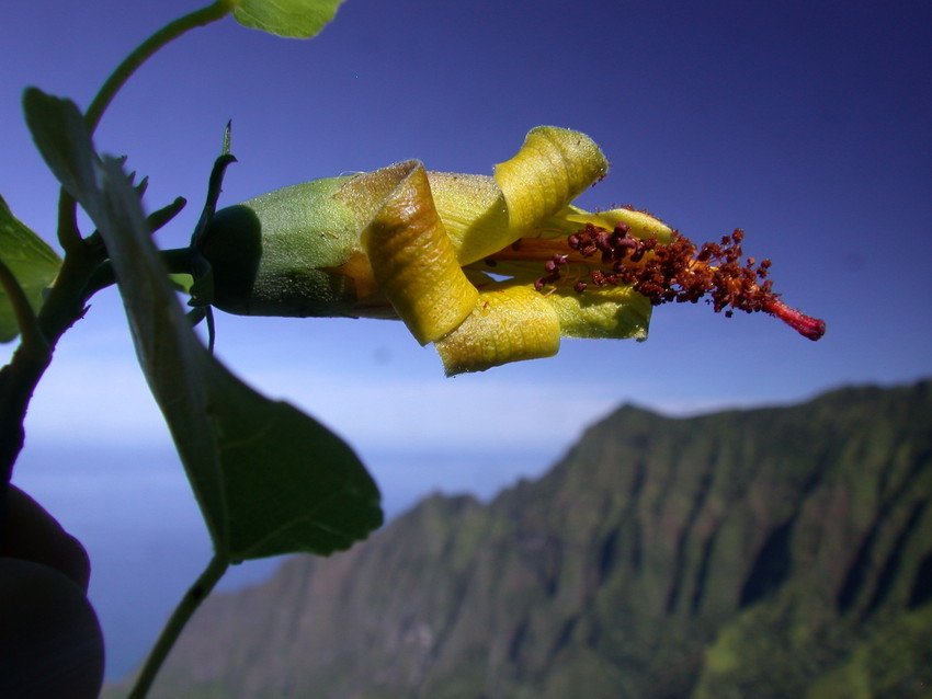
In January this year, a drone photographed individuals of Hibiscadelphus woodii, a relative of hibiscus that was previously thought to be extinct, in a remote part of the Kalalau Valley in Kaua‘i. Earlier, drone footage had helped the NTBG team discover new populations of critically endangered plants like Laukahi (Plantago princeps var. anomola) in areas that are nearly impossible to access on foot, at least using currently available technologies.
In fact, drones are opening up new opportunities for plant conservation in Hawaii. Nyberg and the NTBG staff have used drones to not only search for and locate rare plants, they’ve also used drone video to meticulously map and monitor the NTBG’s network of gardens and preserves on the Hawaiian islands, monitor the rapid spread of disease among the native ʻŌhiʻa trees, and survey the damage caused by landslides after severe rainfall events.
Mongabay spoke with Nyberg recently about how he uses drones for plant conservation — his process, the challenges he faces, and the future upgrades in the technology that could make his work easier.

Mongabay: When and how did you start working with the National Tropical Botanical Garden?
Ben Nyberg: I’ve been working in the conservation profession here in Kauaʻi for seven or eight years. I was working with The Nature Conservancy prior to this and a job came open with the NTBG and I jumped at the chance to work with the organization.
How did you become a drone specialist?
I had a private consulting business in which I was using drones to create maps and elevation models and do some aerial imaging. I thought it applied really well for conservation especially to look at cliff habitat. I brought the drone in and we started testing it for that purpose and found that it worked really well. That sort of started the program at NTBG. And we’ve just expanded and continued to work on our methodology.
When did you first start using drones at NTBG?
Around two and a half years ago.
What kinds of drones do you use for your work?
We’re using DJI drones. They’re consumer grade and easily available and fairly reasonably priced for all their specs. For now they’re doing the job that we need them to do, which is survey, map and inventory rare plants with a camera.
We started with the Phantom 3, then we switched to Mavic Pro when it came out because it was more portable. The Mavic Pro is a foldable drone that we’re able to hike with in a backpack. When the Phantom 4 Pro came out, we upgraded to that model. That has a better sensor on it — it has a 20-megapixel camera and the images were coming out much better using that.
What are some of the advantages or disadvantages of the drones you use?
What they’re really effective at is stability. We work a lot in windy conditions, but they attach to many satellites at the same time, so they’re able to hold their location, and give us fairly precise location data as to where the photo was taken and where the rare plants are. They’re also able to get into some locations that we’re not physically able to reach on foot. So for assessing cliff habitat they’ve been really useful.
One of the problems we have, like I said, is weather. We are in really cloudy and moist environments and that can be a limitation. Also, if we get into areas that don’t have good GPS reception the drones are much harder to use. Up until now, we can observe the plants. But we’re trying to work out what the next steps are and how we can interact a little better. Whether it’s depositing seeds or collecting seeds or something along those lines.
How often do you experience problems with GPS reception?
There are certain locations on the island, which due to the terrain mean you’re in these tight canyons that don’t have a lot of sky available to connect with satellites. There are definitely certain locations where we run into problems like that. The weather here changes really quickly too, so it can be unpredictable. It’s an ongoing challenge with that one and we don’t always know when that’s going to present itself

What’s the battery life like for the drones you use?
The battery life is quoted at about 30 minutes, but realistically we probably get around 20 minutes per flight. As part of our kit we usually bring about six batteries along with us. We’re averaging a little over two hours of flight time per field day.
What kinds of regulations do you have to think about when using drones for your work in Kauaʻi?
The pilot needs to be FAA [Federal Aviation Administration] certified in the U.S. and have a license to fly. As part of receiving our license, we have to fly within the regulations they set, which include always being within 400 feet [120 meters] of the ground, not within 5 miles [8 kilometers] of an airport and not near clouds. There’s a lot of helicopter traffic in our area on Kauaʻi, so that’s something that we’re always very focused on — making sure that we’re out of air traffic routes.
Do you have to be careful of other wildlife in the area while using your drones, like birds?
On Kauaʻi, the main bird interactions we have are with the white-tailed tropicbird [Phaethon lepturus]. They’re very interested in it. They’re very territorial and they’re cliff-dwelling, so they come and investigate it and fly fairly close, but we’ve never lost one to a bird yet. There aren’t many birds of prey around Kauaʻi so that’s not as big of an issue as it is in some other areas where eagles and falcons will attack drones.
At the NTBG, what conservation applications do you use drones for?
We use it to create our aerial imagery and elevation models of our gardens, and to map plants within the gardens. Once we have the aerial imagery, we can make maps with those images, create contours and assess areas we want to work on. In the field, we use it to look for and monitor invasive plants and to survey rare plant species as well. We’ve also been using it to look at landslide features. We just had a huge rain event here on Kauaʻi last April. We received 50 inches [1,270 millimeters] of rain in 24 hours that led to these widespread landslides around our properties. So it was a really useful tool for assessing the damage from the landslides.
I’ve also read that you use drones to monitor disease spread?
Yes. There’s a fungal pathogen of the ʻŌhiʻa tree, which is sort of a keystone forest species here in Hawaii. We’ve been looking for signs of disease spreading around the island with the drone. When the fungus gets into the tree, it causes mortality really quickly. Sometimes the tree will die in two weeks, but sometimes the leaves will be on it and turn red, so we get the indicators either as trees with red leaves or a tree that’s lost all its leaves and there’s a big dead tree. That’s what we look for from the air.
Can you take us through how you go about surveying rare plants?
My predecessor here at NTBG was really into GIS modeling and creating predictive analysis of where hotspots for rare plants would be. So when I stepped into the job, I looked at those maps and started thinking about how are we going to access these areas, how are we going to survey — that’s where drones came up.
I’ve sort of been using that as my first idea of where to start and sort of picking out locations that are inaccessible and have high probability of rare plants. I’ll scout it in Google Earth or on a Topo map and look at what my sight lines will be like. Then I select flight locations that will allow me to look at the full surface that I’m trying to survey. Sometimes I can drive up to some of the locations. Other times I have to hike. Occasionally we’ll have to take a helicopter to those locations.
When I arrive at my flight location, I will do a quick look around and trim trees to make sure I have a good line of sight and an open area to fly the drone from. I will also scout with my binoculars before I start flying to see if there’s anything of interest before I get the drone in the air. I’ll pick locations that I think look good, then I will take off and fly over there. I usually have an assistant who’s a botanist. They keep their eyes on the drone at all times.
I fly using the live view that the drone sends back to the pilot and navigate my way into areas that I identified both from the predictive models and from my binocular surveys. Once I get into an area, I look for keystone species and native cliff habitat. It tends to be in better shape if there are lots of native plants there. That’s the kind of the area I’ll focus on. I try and get in within 5 to 10 meters [16 to 33 feet] of the surface and work systematically over those nice patches of forest. When I’m in about 5 meters or so, I can get resolutions where each pixel is a millimeter, so I’m able to identify really small plants and I also get a better GPS point because I’m closer to the location of the plant.
After my battery runs out, I’ll pick a leave-off point and keep cycling through that whole process until I’ve run through all my batteries or we’ve covered the territory. Then I’ll bring all the photos to my lab. I use Adobe Lightroom as my post-processing software. I really like the “People” feature in Lightroom that allows me to put boxes on top of each photo. When I identify a plant, I can tag it, so I can re-find that photo and export it with its GPS location and put a point on a map from there. It also allows me to tabulate my numbers. Some species we work with are extremely rare and there may only be 10 to 20 individuals but some are much more relatively common with individuals in the thousands, so Lightroom allows me to tabulate how many I see in these different areas.
You mentioned you look for keystone species to identify areas to survey. Could you give an example?
On the cliffs there are lots of native grasses, which is one thing I’ll look for. There are also smaller shrub-type plants that are easy to pick out with naked eye, either by color or by shape, and those plants to me, indicate that there’s a high likelihood of finding other rare plants in the area.
Does the drone flight pattern affect the kind of footage you get?
When I was first starting out, I was thinking of doing a more automated survey technique, sort of programming grids and having lots of overlaps so I could stitch them all together and get these really nice coverage maps of cliff areas. But the more I worked with that method, I found that I was getting lots of photos of weedy areas or bare cliff and areas that weren’t very interesting, and it ended up eating a lot of the flight time covering areas that weren’t that good. So I switched to a more manual flight method. Now I’m using my intuition along with the keystone species that I talked about earlier and trying to be systematic but also leaving some openings for me to use my intuition.
How many photos do you end up with after every field day?
I usually end up with 40 to 50 photos every 20-minute flight. So over six flights, I’m somewhere in the 300 photo range from a day of flying and that can take almost a full day to post-process. Each field day leads to a day in the office.
How often are you in the field?
I’m in the field about twice a week, and the rest of the week in the office.
Do you manually identify all the plants in the photos or do you use AI?
Right now we’re working with manual identification. We’ve looked at AI or image classification in an automated way but there are so many plants we don’t even know we’re looking for, so asking the computer to find plants that we don’t know are there, is difficult. In a lot of instances, we don’t even have reference photos for the plants to look for.
Do the other botanists at the NTBG help you identify the plants?
Yes. I usually do the first pass. I’ll look through the images, identify the ones I can, then for the ones I can’t, I draw boxes with questions and bring the plant experts down to help me identify those plants.
Your recent rediscovery of Hibiscadelphus woodii made big news. Could you tell us how that happened?
We got a grant from the Mohamed bin Zayed Species Conservation Fund aimed specifically at the rediscovery of the species. The species was only ever known from four individuals. We started out by surveying the area right where those previous individuals were known from. We did an initial survey right in that area and came up with nothing. For a few months, we were trying to get back into that area but the weather was rainy and not conducive to drone survey, so we got delayed. We finally caught a good day in January this year. I went with a couple of my colleagues, botanists Ken Wood and Steve Perlman, down to the area where the previous individuals had been and started working next few valleys or drainages over.
We were working from above and going down about 800 feet [240 meters] off the edge of a cliff. We spent a day in the field there checking out an area of couple hundred acres probably. We didn’t notice it from the live view or while we were in the field, but when I brought the drone back to the lab and was looking through the 300-odd photos that I had collected, I saw that we had one photo where the plant was in right in the lower corner almost off the photo.
I’m not an expert on the species, but I said, hmm that looks like it but I better go get my botanist friends who really know the species in and out. My colleague [Ken Wood] is the one who actually discovered it in the early 1990s. He came down to my office and we were looking closely and pulling up old photos and comparing them, and we were pretty confident that that was what it was. We were really excited and high-fiving but then we needed to go out and confirm. We tried three more times to go up and survey but the weather kept us from surveying. The fourth time we tried, we got a really nice day. We were able to relocate the plant and as we were flying around, we found two or three additional individuals. It was really exciting to be able to rediscover this species. It was an awesome experience.
You mentioned you had a grant to look for the plant. Did your team suspect that more individuals could be out there?
I don’t know if we suspected but the terrain in this area is so dynamic, it’s really thousands of cliffs that have never been surveyed. There wasn’t a lot of hope until the drones came along that we’d ever be able to survey those areas. Once we started seeing the power of the tool, that’s when we started getting excited about the opportunity of checking these areas.
What skills does one need to become a drone specialist to do the kind of plant conservation work that you do?
Patience. We’ve been doing this for two and a half years and there’s a lot of technical things that you need to learn and be comfortable with. We’ve also run into lots of permitting and insurance issues, so I think it took us 18 months to get an OK to work in these areas with the state and local governments. So patience is a big part.
It also takes some technological experience. These days people are getting more and more comfortable with using their phones and computers, so just general troubleshooting electronics, I think, is important. I’m really impressed by the engineers who design these drones and are able to put them out at such reasonable price that most people can go to the store and pick one and start flying immediately.
In the botany side of things, I’m learning as I go. Having a support team around you that can help you is another big part of it.
What progression or advances in drones do you see that would make it easier for you to do your work?
I’m working on a couple of things that would make my work a lot easier. One of them is an automated survey, sort of an AI-smart survey, where you can program in these keystone species and the drone can pick on those areas and sort of realize that it’s a good area to survey and check. But when it’s bare cliff or weedy, they understand that and they’ll avoid those areas. I think as the sensors on the drones get better, being able to avoid obstacles in an automated way is another thing that will really help.
Then as I mentioned earlier, I’m working with some researchers who are working on cutting mechanisms on drones that could collect plant material remotely. That would be a huge help. Take Hibiscadelphus woodii, for example. We may not ever be able to get to the plant with traditional rope methods and we can’t walk to it. But we’re trying to figure out how we can help that species without being able to get to it. That’s where being able to interact, maybe via a pollination arm that could help these plants get pollen between them, or something that could help collect seeds, or take cuttings that we could graft, would be helpful. Being able to increase our toolbox is sort of the next step for us.
Banner image of cliffs on Kauaʻi island by Ben Nyberg.