- Recent studies of an elusive otter species living in the highly modified mangroves and reclaimed lands on the coast of Goa, India offer new insights into otter behavior that could inform future conservation efforts.
- Researchers have studied these adaptable otters with camera traps, ground GPS surveys, and satellite images; they’re now testing drone photogrammetry to improve the accuracy of their habitat mapping.
- Using data gathered over a period of time, the researchers aim to pinpoint changes in the landscape and, in combination with the behavioral data gathered by the camera traps, understand how otters are reacting to these changes.
Human-dominated mangroves are far from what is considered an ideal environment for otters. And yet an estuarine island on India’s western coast is home to a thriving population of the threatened smooth-coated otter (Lutrogale perspicillata). Recent studies of this elusive species living in the brackish waters of Chorao island—far from the freshwater sources that otters are typically believed to rely on—offer new insights into otter behavior that could inform future conservation efforts.

“There’s not much written about smooth-coated otters in mangroves…especially in a human-dominated landscape,” said Katrina Fernandez, a member of the IUCN Otter Specialist Group and director of Wild Otters Research (WOR), a research and conservation organization. “The fact that the smooth-coated otter is so adaptable to change and to human-dominated landscapes, enabling it to coexist within this ecosystem, is fascinating,” she added.
Although the smooth-coated otter has been documented across large parts of South and Southeast Asia, their presence on Chorao, in the state of Goa, has required them to adjust to a variety of vegetation types, most of which are subject to anthropogenic change.
The most obvious of the adaptations that these otters have made is learning to live within the constraints of the khazans, a type of human-created landscape unique to Goa. According to Nandkumar Kamat, assistant professor at the Department of Botany at Goa University, “generally any low-lying land close to a mangrove-fringed estuary reclaimed by salinity control structures can be called as khazan land.” Also known as communidade lands, they are typically owned and maintained by local communities and used for agriculture and acquaculture.

Fernandez and her team have observed unique behavioral adaptations by otters living in this human-dominated khazan ecosystem. For example, the otters routinely make dens on the banks separating the khazans from the estuary and scale the retaining walls of these banks to defecate and to groom themselves. WOR’s researchers have also gathered extensive evidence of the threat stray dogs pose to Chorao’s otter population.

Stray dogs on Chorao island can harass and pose a threat to otter families already facing challenges. Video courtesy of Wild Otter Research.
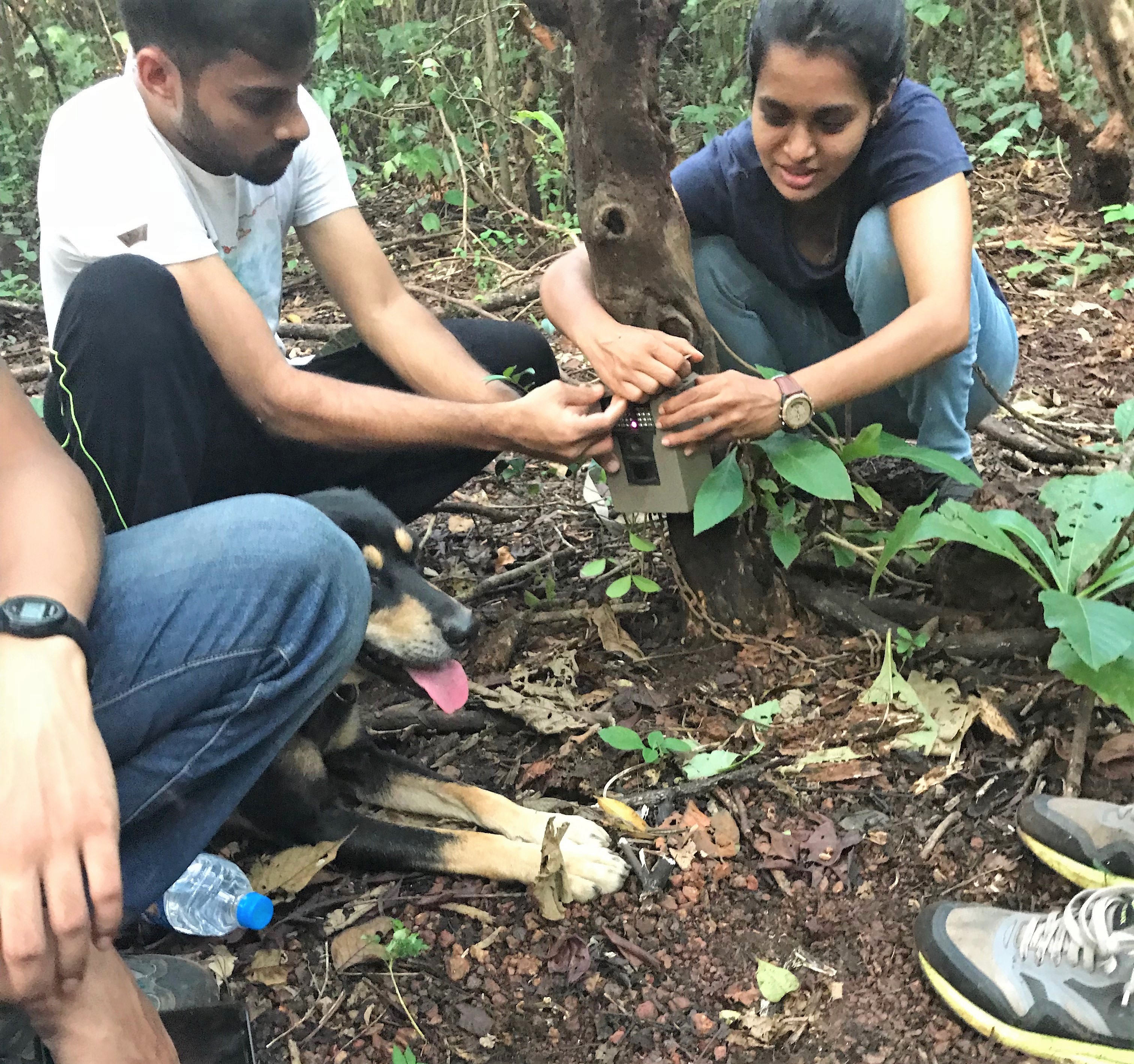
These discoveries have so far combined ground-based surveys, which require researchers to manually walk the periphery of the island looking for signs of otter defecating and grooming sites, with camera-trapping, which involves positioning a still or video camera at these sites to study otter behavioral patterns. These cameras are triggered by heat or motion sensors and use an infrared light source to capture visuals at night, while ensuring the otters are barely aware that they’re being watched.
Although these cameras are currently WOR’s primary source of data, they are also a source of frustration for the researchers, as they have sometimes proven to be unreliable in the mangrove environment. “We choose the middle ground in terms of price, because functionality is decent and you don’t feel too much of a pinch if they are stolen,” Fernandez said.
However, extreme temperature changes in the monsoon and summer months led to numerous malfunctioning cameras.
Theft and displacement by curious locals also threaten the cameras. “We’re always wary of putting cameras in new places and very public spaces,” Fernandez said. The researchers have to hide cameras under vegetation to make them inconspicuous, an onerous requirement in a wetland terrain which already offers limited opportunities to position a camera. The need to frequently change batteries and the lack of high-quality microphones on these cameras are also pain points for the researchers. “At some point, I want to look into just manufacturing our own,” she added.
Even when they’re not fiddling with the cameras, nearby humans inform the way WOR designs its research and conservation efforts. Although direct human-animal conflict is low, the impact of humans on the otters through habitat destruction is immense. The reclaimed khazan lands in particular, which are under perennial threat of being overrun by the mangroves that originally owned them, are the subject of a constant tug of war. Local residents cut, burn, and/or remove what they see as invasive vegetation using earthmovers to maintain the economic viability of these lands.
“Development, or human encroachment, is going to increase,” Kshitij Garg, WOR’s Communications Director, told Mongabay. “If you can know the extent to which this species can adapt and survive, then you can direct human activity in the right way. This is why most of our work is outside of protected areas. We aren’t only studying their behavior. Knowing which actions of the human community are affecting the animal and which are not is paramount to any realistic conservation efforts.”
Surveying from above and below
To improve their understanding of these effects, the Wild Otters researchers are incorporating new technologies to help them map the Chorao landscape and document its changing land-use patterns. Currently at a nascent stage, their efforts will combine satellite imagery and drone mapping with ground-based GPS surveys to target their actions to ensure the otters’ continued survival on the island.
“If we decided to use a satellite image, it might be a bit out of date. Also, it’s quite hard to tell what the actual habitat is from the satellite image alone,” said Sophie Darnton, a research intern with WOR.
The researchers conduct ground surveys to collect GPS waypoints to update satellite-based maps of the habitats frequented by otters and areas of human activity. They walk several survey routes on the island using GPS devices to manually record the extents of different vegetation types, areas frequented by otters, and other points of interest, including sluice gates, farms, and fishing areas.

Smooth-coated otters rolling in the dirt. Otters roll in dirt or vegetation to communicate their presence and possibly their identification through scent marking. Video courtesy of Wild Otters Research.
They hope that over time, these updated maps, combined with the behavioral data on otters gathered using camera traps, can provide clues about the effect of human activity on the otters.
WOR also collaborated with Technology for Wildlife, a geospatial data company helping groups use technology to conserve wildlife and the environment, to carry out a drone mapping pilot study in Chorao in May and June of 2018. Photogrammetic mapping using drones generates 3D models of the landscape below, allowing researchers to pinpoint even minor changes to habitats in areas that are inaccessible to humans.
“You get a much more holistic view of an area when you have both groundwork and drone-imagery and satellite imagery on top of that,” said Shashank Srinivasan, director of Technology for Wildlife. “A dense mangrove forest where it is not possible for a boat or a person on foot to go into because its swampy or wet… you can use a drone to fly over that. In that way, drone imagery is very complementary to ground-based work, and it really fills a gap in the entire process.”

A camera trap captures a family of smooth-coated otters. The pups reach adult size after about a year. Video courtesy of Wild Otters Research.
Srinivasan said the results of the pilot study suggested that drone mapping can replace many components of traditional fieldwork. “Technologically, there were a bunch of experiments and research we were doing with that imagery,” Srinivasan said. “When you create a 3D model, can you ascertain the height of a dyke, can you use a bunch of analysis techniques to distinguish between vegetation and open water and even different kinds of vegetation? And the testing validated that we can actually put a project together around this.”
Srinivasan conducts drone mapping using relatively inexpensive quadcopter drones that carry standard RGB cameras. Depending on the level of detail required, they can cover between one and 20 hectares (2.5 to 49 acres) in less than 45 minutes using an automated flight plan. Processing the resulting data, however, can take up to a week and constitutes the core value addition that Srinivasan and his company provide. “It’s easy to fly a drone but much harder to create meaning from the data,” he told Mongabay.
The images captured by the drones are processed using a battery of software tools, including Pix4D, VisualSFM, Blender, QGIS and ArcGIS. The techniques involved—photogrammetry, making measurements from a set of overlapping images for 3D models and orthomosaics, creating overlapped, geometrically corrected aerial images for 2D maps—essentially boil down to extracting meaning from the individual pixels in the images. “There are statistical operations you can use which will allow you to identify which pixels in a particular image are vegetation, which are open water, and so on,” Srinivasan said.
Using data gathered over a period of time, the researchers aim to pinpoint changes in the landscape and, in combination with the behavioral data gathered by the camera traps, understand how otters are reacting to these changes.

Despite the promise of their pilot study, the researchers have had to delay its roll-out on Chorao due to funding and regulatory issues. The organizations are now awaiting responses to their grant proposals and clarity on India’s new regulatory framework for drone activity, which has left the rules for flight permissions in a state of uncertainty.
Srinivasan said he remained optimistic about the use of these new techniques in the region. “It is an exciting time for drones in general and specifically for conservation work,” he added, “because there’s so much potential to help save wildlife and the environment.”
FEEDBACK: Use this form to send a message to the editor of this post. If you want to post a public comment, you can do that at the bottom of the page.