- Forest monitoring has increasingly turned to satellites over the past several decades, and 2018 was no exception.
- In the last few months, NASA launched two sensors into space that will play a prominent role in monitoring forest biomass and structure over the next decade: the Global Ecosystem Dynamics Investigation (GEDI) now attached to the International Space Station, and the Ice, Cloud, and Land Elevation Satellite-2 (ICESat-2).
- These two satellites, which in combination provide complete coverage of the planet, are equipped with lidar sensors that record forest structure in 3D, contributing to an ongoing wave of large-scale forest ecosystem measurements.
Researchers and forest managers working to record and reduce the rapid loss of forests are now armed with a new tool to monitor vegetation across the globe. In December 2018, a SpaceX rocket launched the NASA-engineered Global Ecosystem Dynamics Investigation (GEDI) sensor up to the International Space Station to gather data on the structure and extent of forests.
Scientists have increasingly relied on remote sensing methods to estimate the extent of forest landscapes, in particular collecting data from space at a large scale. Over the next several years, GEDI will provide the most accurate lidar (light detection and ranging) data on tropical and temperate forests ever to be collected from space.
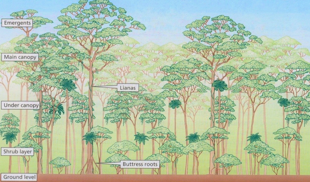
Satellite lidar systems determine vegetation structure by emitting lasers down to Earth at a known distance from the planet’s surface and measuring the time it takes for the lasers to return to their origin. As the satellite orbits the Earth, its lasers bounce off different features of a landscape. Shorter return times correspond to taller features, such as the top of a forest canopy, while longer return times correspond to shorter features, such as grassy plains. Where elevation of an area is known, very precise heights of vegetation features can be determined across the landscape.

NASA’s Global Ecosystem Dynamics Investigation (GEDI) sensor launched to the International Space Station in December 2018 offers a 3D view of temperate and tropical forests. Video by NASA Goddard Space Flight Center.
The benefit of GEDI’s lidar is its ability to collect forest structure data in three dimensions, which enables scientists to not just categorize different types of land cover but also record vegetation canopy height and tree density, which other satellite sensors cannot. GEDI’s lasers will also penetrate the forest canopy to map understory growth, surveillance that no satellite to date has been able to do and would otherwise be near impossible without the difficult fieldwork of measuring forest biomass and carbon storage from the ground.
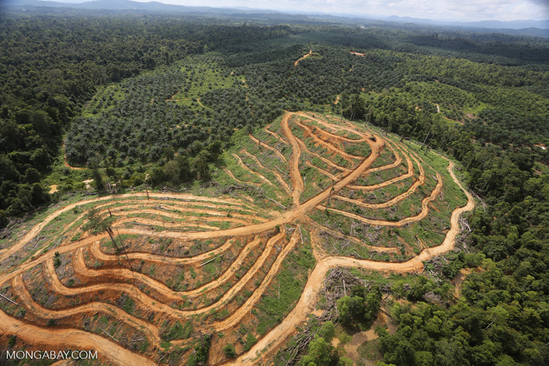
Scientists agree that forests are disappearing rapidly and globally, but the speed with which the world is de-greening and how much of Earth’s carbon and biodiversity are lost along with forests are not well understood. The amount of carbon released when forests are cut down or burned depends on the amount of biomass the forests contain. Carbon emissions from deforestation play a substantial role in assessing the impact of human activity on climate.
“The largest gap is that we do not know the existing carbon stocks of the Earth’s forests,” Dr. Ralph Dubayah, the principal investigator of GEDI and professor of geography at the University of Maryland, told Mongabay. “Canopy height provides a direct link to a tree’s weight because just as with humans, larger trees weigh more than younger trees. About half a tree’s biomass is carbon. So if we know the heights globally, we can make much better maps of global forest carbon.”
Satellite-mounted lidar can also help scientists record how long it has been since a forest starting growing or was last cut down, also known as its successional state. Trees in old-growth forests tend to be bulkier and taller and therefore store more carbon and offer unique ecosystems that younger forests don’t.
“Conventional satellite data can show you when a patch of forest has been lost, disturbed or degraded,” said Dubayah, “but you don’t know how much that deforestation has contributed to atmospheric CO2. The net balance between how much you lose through deforestation and how much you gain through regrowth is one of the largest uncertainties in the global carbon cycle.”
Combined, satellite lidar sensors scan entire planet’s surface
GEDI was not the only lidar sensor NASA sent to space in 2018. ICESat-2, a satellite launched in mid-September 2018, is also beaming lasers down from space as it orbits the earth at a speed of 4.3 miles per second. Although ICESat-2’s primary mission, and namesake, is monitoring polar ice caps, the lidar lasers shot from its sensor will also record elevation and structure of the vegetation, ocean, and rocky surfaces surrounding the polar regions, including those of the boreal forests. These high-latitude data would complement those of areas closer to the equator generated by GEDI, said Dr. Joe MacGregor, a NASA glaciologist on the ICESat team. “Along with ICESat-2’s polar coverage, GEDI will cover between 51° latitude North and 51° latitude South to round out the picture.”
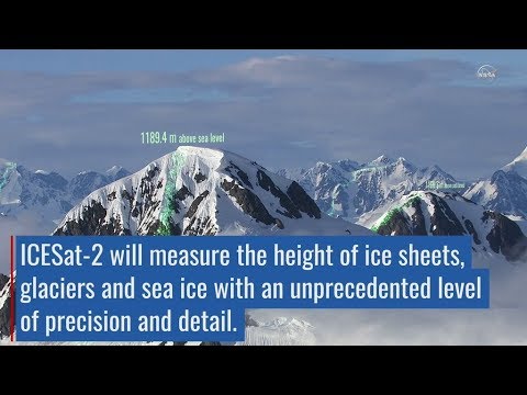
ICESat-2, a lidar satellite launched in September 2018, will complement GEDI measurements of tropical and temperature forests with its own extensive coverage of boreal forests near polar regions. Video by NASA Goddard Space Flight Center.
ICESat-2 is the successor to ICESat-1, which launched in 2003 and orbited until 2010. ICESat-1, which also had a lidar sensor, enabled NASA scientists to create the first global map of an average forest canopy height for every square kilometer (0.4 square miles). The new ICESat will yield an updated global map of canopy heights that is expected to be 1,000 times higher resolution than the ICESat-1 map, and GEDI will map forest canopy metrics at an even higher resolution (a grid of 25-meter cells).
The new ICESat is equipped with a particular flavor of lidar that is excellent for mapping the depth of ice sheets and the canopy height of forests, but it has difficulty penetrating the dense vegetation of tropical rainforests—the forests that GEDI is conveniently positioned to map with its vegetation-optimized lidar sensors.
“We have a project looking at merging GEDI and ICESat-2 data for estimating biomass,” Dr. Laura Duncanson of NASA told Mongabay. “The two science teams are working closely together.” Duncanson said she and members of the ICESat-2 team had joined each other’s meetings and plan to continue their coordinated efforts to integrate data.
Biomass monitoring has become increasingly important with the onset of carbon accounting programs such as REDD+ (Reducing Emissions from Deforestation and forest Degradation), which aim to provide monetary incentives to conserve forests that offset the potential value lost by not cutting down forests. Knowledge of how much carbon is stored in a given area of forest is crucial for establishing such offsetting programs, although international efforts to establish emission accountability metrics have continued to fall short of goals. Nonetheless, carbon cap-and-trade markets are growing, as are the prospects of initiating a carbon tax in some economies.
Besides biomass and carbon stock measurements, this global-scale lidar data will inform other research as well. Recording canopy height and various metrics of forest complexity at large scales enables scientists to characterize different forest ecosystems. When paired with on-the-ground species distribution data, ecologists can roughly estimate the biodiversity of forests, which can help set conservation priorities. Years of satellite lidar data can also improve understanding of how forest structure changes over time due to tree growth, mortality, and competition.
Building and launching satellites requires deep pockets up front but can save researchers a vast amount over time. GEDI’s budget of $94 million pales in comparison to the budgets of the Landsat-9 land monitoring satellite ($885 million) and the European Space Agency’s Copernicus mission ($4.9 billion). The low cost of GEDI is largely thanks to hitching a ride on the International Space Station and expedient progress by NASA scientists and engineers.
“Conceiving and creating the technology in such a short span (four years) on this budget has been a major accomplishment,” Dubayah said. “GEDI was completed six months early and under budget, which is nearly unheard of.”

A new hope for forests?
Although both the GEDI and ICESat-2 lidar sensors will likely last only until 2021 and 2022, respectively, researchers and land managers use the data from ecosystem satellites for many years: ICESat-1 maps are still contributing to conservation science 10 years after the satellite was decommissioned. As the costs of large-scale, high-resolution forest monitoring decrease, so does the availability of data and tools to track land cover change at incredibly fine scales.
These two lidar sensors complement the fine-scale (5-meter, or 16.5-foot) synthetic aperture radar (SAR) satellites already in orbit, and the next decade will likely witness the launch of NISAR, a joint initiative between the United States and India, and the European Space Agency’s BIOMASS mission, both of which are assigned to record global environmental changes.
In a galaxy far, far away, Jedi see through others with the Force. Starting this year above our own planet, GEDI can now see through the forest. According to Dubayah, the dramatic advances being made in remote sensing technologies will improve scientists’ ability to measure– and therefore better protect– the extent and structure of global forests.
“We are entering a new era of ecosystem observation where we can finally get at canopy 3D structure,” he said, “a very exciting development indeed.”
Citation
Neuenschwander, A., & Pitts, K. (2019). The ATL08 land and vegetation product for the ICESat-2 Mission. Remote Sensing of Environment, 221, 247-259. https://doi.org/10.1016/j.rse.2018.11.005
FEEDBACK: Use this form to send a message to the editor of this post. If you want to post a public comment, you can do that at the bottom of the page.