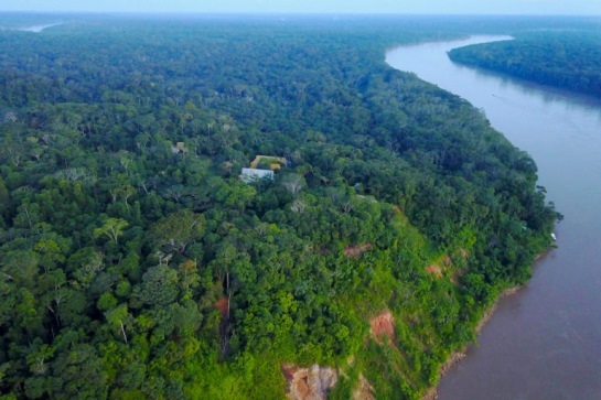
- Brazil nut and ecotourism concessions in the Amazon maintain intact rainforest, but deforestation by illegal loggers, miners, and agriculturalists threaten the integrity of these lands and the Brazil nut industry.
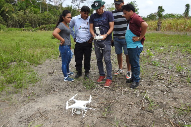
- The Peruvian NGO Conservación Amazónica – ACCA is training concessionaires and forestry officials in southeastern Peru to fly drones and monitor the properties they manage using drone-based cameras.
- The resulting high-resolution aerial images enable concessionaires to detect and quantify deforestation within their Brazil nut, ecotourism, and other forest concessions and support their claims of illegal activity to the authorities.
Flor Rumayna and Sara Hurtado arrived in Lima this past August from their homes in the Amazon headwaters to learn more about aerial monitoring of forests. They’d been researching new technologies for several months to help them protect their forest concessions in Madre de Dios Peru, a region in the southeast of the country facing increasing levels of deforestation.

They have already learned of several tools to help them manage their lands, including georeferenced alerts of possible deforestation events that arrive directly to their cell phones and techniques to monitor their lands from above using small commercial unmanned aerial vehicles, or drones.
“I have always believed that technology can help us take care of our concessions,” Hurtado told Mongabay-Latam, “because, as they are large tracts of land, we face the danger of squatters and illegal loggers entering.” She currently manages two Brazil nut concessions in Madre de Dios, totaling almost 1,500 hectares (3,707 acres) of forest.

Rumayna recently received her diploma as a certified drone pilot, which will enable her to more efficiently monitor the illegal activities that damage the forest in her ecotourism concession. “Technology helps us with our work,” Rumayna said. “Before, when I heard a machine, I had to search for the loggers. Now, with the drone, I can locate from the air where the problem is occurring. ”
Fighting crime
Two years ago, Conservación Amazónica – ACCA (ACCA) began a project to train forest concession owners and public officials in Madre de Dios to fly the small commercial drones.
Winning the “Google Challenge” provided ACCA with the necessary resources to advance a project to monitor Brazil nut concessions through the use of technology. The project focuses on detecting illegal activities, improving patrols, and defending the rights of concessionaires to retain their needed forest cover.
In the Amazon, Brazil nuts are gathered primarily from wild trees in the forest, rather than plantations, and their harvest is compatible with retaining native forest cover. The bees that pollinate their flowers require intact forest, and plantations produce little fruit.
Concession owners manage land for Brazil nut harvest or ecotourism under contracts with the Peruvian forest service, allowing them to make a living from intact forest. Deforestation, therefore, threatens both the forest cover and the concessionaire’s livelihood. Some 45,000 people, one-fifth of the population of Madre de Dios, benefit from Brazil nut harvesting, and the concessions protect roughly 10,000 square kilometers (3,861 square miles) of forest.
Illegal mining, logging, and small-scale agriculture are the main threats to forested concessions in the region. Hurtado, in fact, recently received a deforestation alert and flew a drone over her property to investigate the area, where she found an illegal settler. The aerial images she took from the drone will now be part of the legal case seeking to resolve the issue. “That was my first overflight experience with the drone in my concession,” she said.
Drone-based images can clearly show where mining, new crop fields, or other deforestation have replaced native forest and serve as evidence for concessionaires to report illegal activity to the authorities.
A new training program
ACCA conducted the drone training at its Los Amigos Biological Station in Madre de Dios. “We are training the Brazil nut concessionaires to detect threats in their forests,” said Daniela Pogliani, ACCA’S executive director.
The project has used two types of drones to monitor the concessions. Multi-rotor quadcopter drones are relatively easy to fly, sold commercially, and have a range of 3 to 4 kilometers (2 to 2.5 miles). They can hover in one place and land with very little open area.
Fixed-wing UAVs look more like small aircraft and can reach higher speeds. They can thus cover greater areas in a single flight and reach remote areas in less time, said Sidney Novoa, ACCA’s director of Conservation Technologies, but they are trickier to fly and require some open space to take off and land.
The drones used by the forest concessionaires are donations from ACCA, as part of the group’s international cooperation projects, Carlos Castañeda, ACCA’s drone program coordinator, told Mongabay. “This donation is made after the concessionaires have demonstrated adequate skills in operating the drone by passing the Ministry of Transportation test,” Castañeda said, “and after signing a document stating they will use the drone exclusively for monitoring deforestation and threats to their concessions.”
So far, more than 10 people from the Timber and Non-Timber Forestry Dealers Association of Manu and Tambopata Provinces (ACOMAT) have gone through the training and, like Rumayna, received their certification in drone handling from the Ministry of Transport and Communications. Government officials have also participated in the training program. Castañeda said ACCA’s target audience for the training courses are the beneficiaries of the group’s projects, including the managers of Brazil nut, ecotourism, and other forest concessions, forest and protected area authorities, and indigenous reserve leaders.
Los Amigos, an area of 1,460 square kilometers (564 square miles) of nearly pristine forest, was Peru’s first conservation concession and is also part of this monitoring project. The concession also faces threats of deforestation due to mining and illegal logging, mainly because mining camps are located at the concession’s borders.
“Illegal logging occurs in remote places,” Pogliani said, “and it is difficult to enter where the problem occurs. Therefore, we use drones to verify if the activity persists or if roads have been opened.”
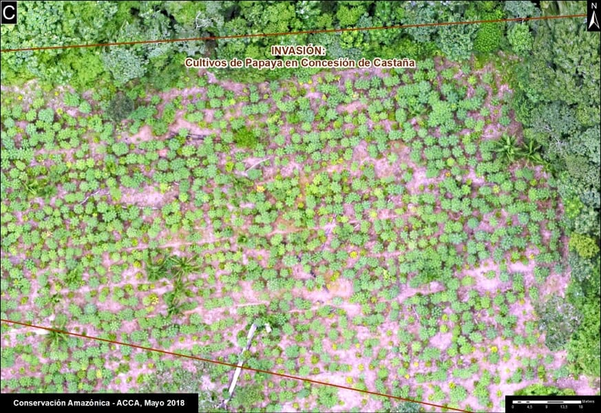
Images in high definition
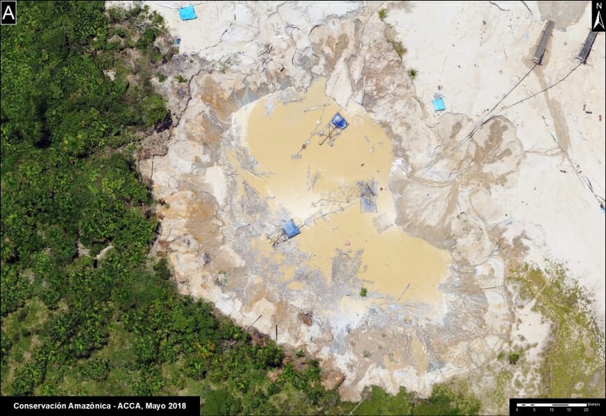
A recent report from ACCA’s Monitoring Project of the Andean Amazon (MAAP) shows the high-resolution images captured by the project’s drones. The report shows very detailed photos taken by drone-based cameras of deforestation for corn and papaya crops along the newly paved Interoceanic highway, as well as gold mining (see photo above).
“These images allow us to observe recent deforestation and also the change in land use,” ACCA’s Novoa said.
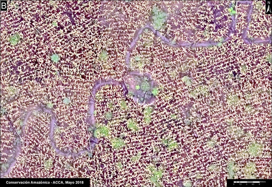
Other images captured in forest concessions of some ACOMAT members have detected damage by hurricane winds and illegal grazing of livestock, another serious threat to forest integrity in the Peruvian Amazon.
Novoa said that in late 2016, ACCA set out to create a drone training center, with a program that allowed its participants to obtain a piloting license from the Ministry of Transport and Communications and to learn complementary skills, such as flight planning and processing the resulting images.
In September 2018, ACCA helped conduct the area’s first basic drone maintenance training to provide a local maintenance service for the teams in the field, Castañeda said. The group partners with qAIRAdrones, a Peruvian company using drones to monitor air quality, to assist with more advanced technical problems.
The project complements the images captured by drone-based cameras with analyses of satellite imagery carried out periodically by MAAP. The Brazil nut concessionaires who now manage drones also know about satellite monitoring and can use the information gained from the satellite imagery to file complaints with the Public Prosecutor’s Office.

Castañeda said that his team aims to involve more concessionaires in tech-based monitoring of their forests, in part by getting the government to recognize the use of drones as valid monitoring technique for managing forested concessions.
The trained Brazil nut farmers are already using these new skills and modern technology to monitor their territory for the presence of any illegal activity within their ancient forests.
This story is adapted from a story initially published in Spanish on Mongabay Latam on August 28, 2018.
FEEDBACK: Use this form to send a message to the editor of this post. If you want to post a public comment, you can do that at the bottom of the page.