
- Researcher Julian Bayliss discovered a forest on Mount Lico by using satellite imagery from Google Earth. In May, Bayliss and a team of more than two-dozen scientists and other experts set out on an expedition to see what kinds of animals and plants lived in the forest.
- According to Bayliss, they found several new species, including a new butterfly.
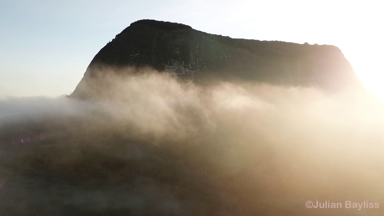
- Protected by 410-meter cliffs, Mount Lico’s forest is undisturbed by human activity. But the surrounding lowlands – as well as other nearby mountains – are heavily cleared for agriculture.
- These mountains serve as important habitat for unique species, as well as critical water sources for local communities. However, their soil is very fertile and often targeted for cropland. Bayliss says these mountain forests need more conservation attention, and urges the development of programs aimed at balancing local livelihoods with forest preservation.
There isn’t much primary forest left in eastern Africa. In Mozambique, there’s officially none, according to 2015 numbers from the Food and Agriculture Association (FAO) of the UN. But a tract of undisturbed forest has recently been discovered and surveyed in the country’s Zambezia province – hidden in plain site at the top of a mountain.
Julian Bayliss, a conservation scientist, initially spotted the forest on Google Earth. This isn’t the first time he’s done so; in 2005, he used the platform to identify an unexplored rainforest on Mozambique’s Mount Mabu. To confirm the presence of this newest forest, Bayliss traveled to the base of Mount Lico and flew a drone to the top of it. Then, in May, Bayliss and a team of more than two-dozen scientists and other experts set out on an expedition to see what kinds of animals and plants lived in this island in the sky.
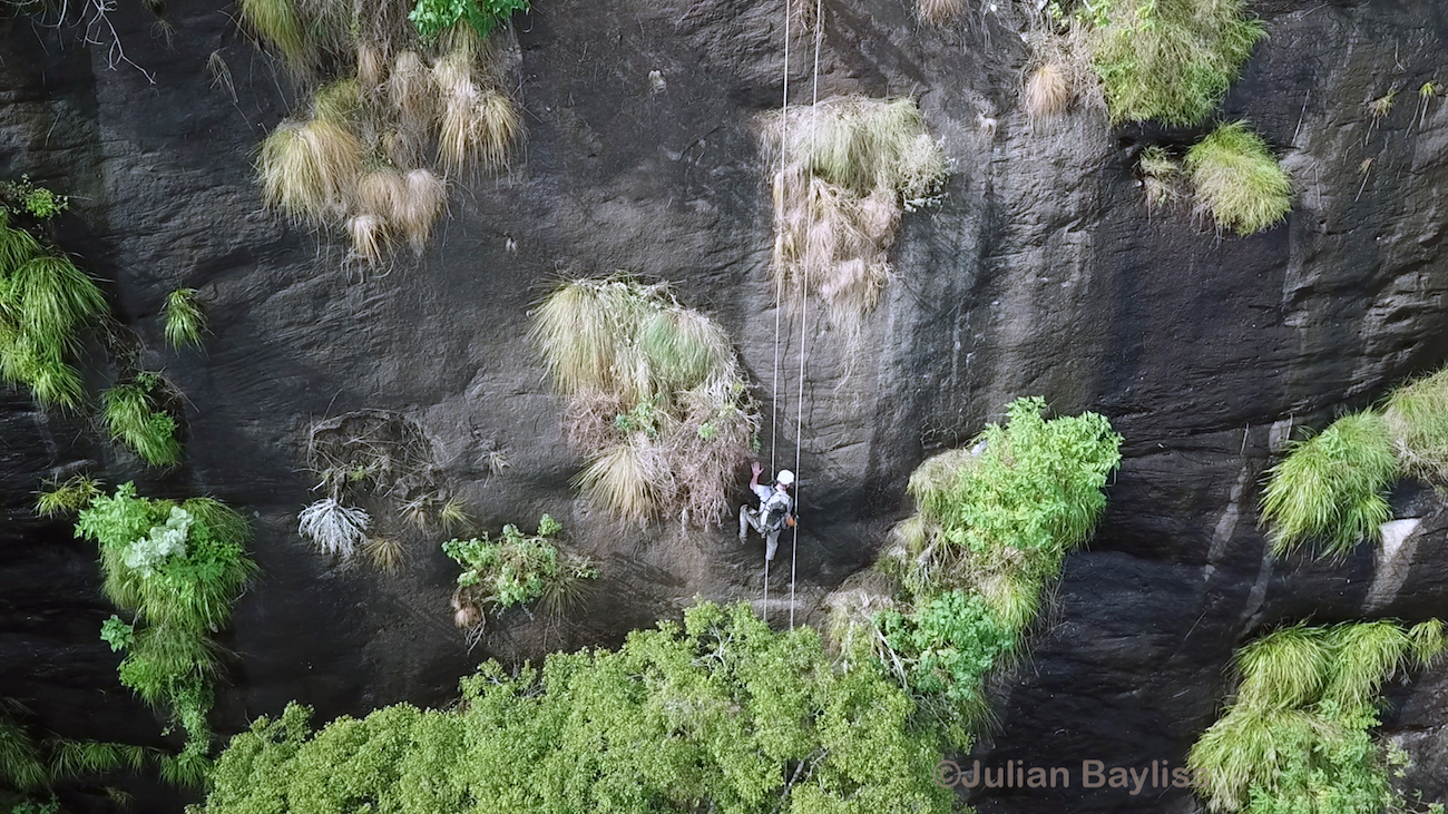
Up they went, using ropes and quickly learned rock-climbing techniques to hoist themselves and their equipment up the 410-foot sheer cliffs. Bayliss was the first to reach the top. As he waited for the rest of his team, he looked around and was filled with an “immense sense of wonder and excitement.”
“The first thing that struck me was just how quiet the forest was,” he told Mongabay. “However, there were signs of many animal tracks in the undergrowth which was very exciting. The second thing that struck me was just how open the forest floor was which is a sign of little disturbance and a closed canopy.”

Over the course of the next two weeks, the team surveyed most of Mount Lico’s forest. They found many different animals and plants, and suspect that several are species previously unknown to science – including a new, distinct butterfly. Bayliss said their full results will be announced in a film that is expected to be released early next year.
Mount Lico and many of the other isolated mountains that decorate the surface of eastern Africa, technically called “inselbergs” (German for “island mountains”), formed when the surrounding plateau gradually eroded away. Areas of hard stone like granite are more resistant to erosion, so they remained while the land around them receded, growing over millions of years into dramatic monoliths.
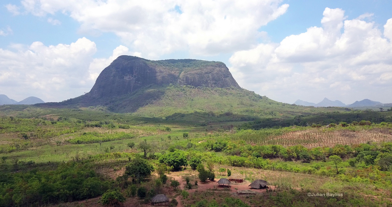
Eventually, they became so high (or, more correctly, the ground became so low) that they were able to influence the local climate, creating clouds and rain as air moved up from the warm lowlands into their cooler upper reaches. Because of this, Lico and other eastern African inselbergs are critical sources of water for the surrounding lowlands – so much so, that local communities call them “rainmaker mountains,” Bayliss said. He described finding clay pots at the top of Mount Lico, which were placed upside down near the start of the primary water source that flows off the mountain. He suspects this was done as a religious offering to try and ensure a plentiful water supply to crops below during the dry season.
“How the person or people responsible for placing these pots were able to scale the cliffs remains a mystery,” Bayliss said. “The local people know of no one in their lifetime who have scaled Mount Lico and been to the forest on top.”
Hear Bayliss discuss the expedition on Mongabay’s podcast, here:

Aside from the ceremonial pots, Bayliss and his team found no other evidence of human disturbance in Lico’s forest. Because of this, he says it can serve as an ideal place for monitoring the impacts of climate change.
“This is what is unique about Lico – any differences we can measure at this site in comparison to other sites should be down to climate change and not site-based human interference,” Bayliss said.
Other inselbergs in the region haven’t been so lucky when it comes to human disturbance. Bayliss and his team also set up another camp at a neighboring mountaintop forest which, lacking the tall cliffs of Mount Lico, has been hit hard by agriculture.
“On the same expedition we also looked at another nearby site called Mount Socone, which I also identified using Google Earth,” Bayliss said. “On this mountain there is a large expanse of rainforest but it is under severe deforestation pressure mainly through local communities planting a mixture of crops (potatoes, maize, cassava, sorghum, beans, etc.) due to the rich humic soil found beneath the forest.”

Mount Socone is not alone in this. Agriculture is a big threat to East Africa’s isolated mountaintop forests, many of which are home to their own arrays of unique species and are important water sources for lowland communities.
“Forests such as these, acting as ‘biological sponges,’ are well documented – absorbing water in the wet season and slowly releasing it in the dry season,” Bayliss said. “The removal of the forests will therefore reduce the amount of available water in the dry season for local communities just when they need it most.”
Bayliss plans to go back to Socone to survey its forests more extensively, and urges the creation of conservation agriculture programs to help balance livelihoods and forest protection – before it’s too late.
“There needs to be an immediate conservation focus on this site before it is too late and the forest is removed completely,” he said. “At the current rate of deforestation we are looking at a few years before the forest is largely destroyed. Therefore we must return to this site.”
For more information about Julian Bayliss and Mount Lico, visit http://julianbayliss.co.uk/lico/
Banner image: The face of Mount Lico by Julian Bayliss
Feedback: Use this form to send a message to the editor of this post. If you want to post a public comment, you can do that at the bottom of the page.