
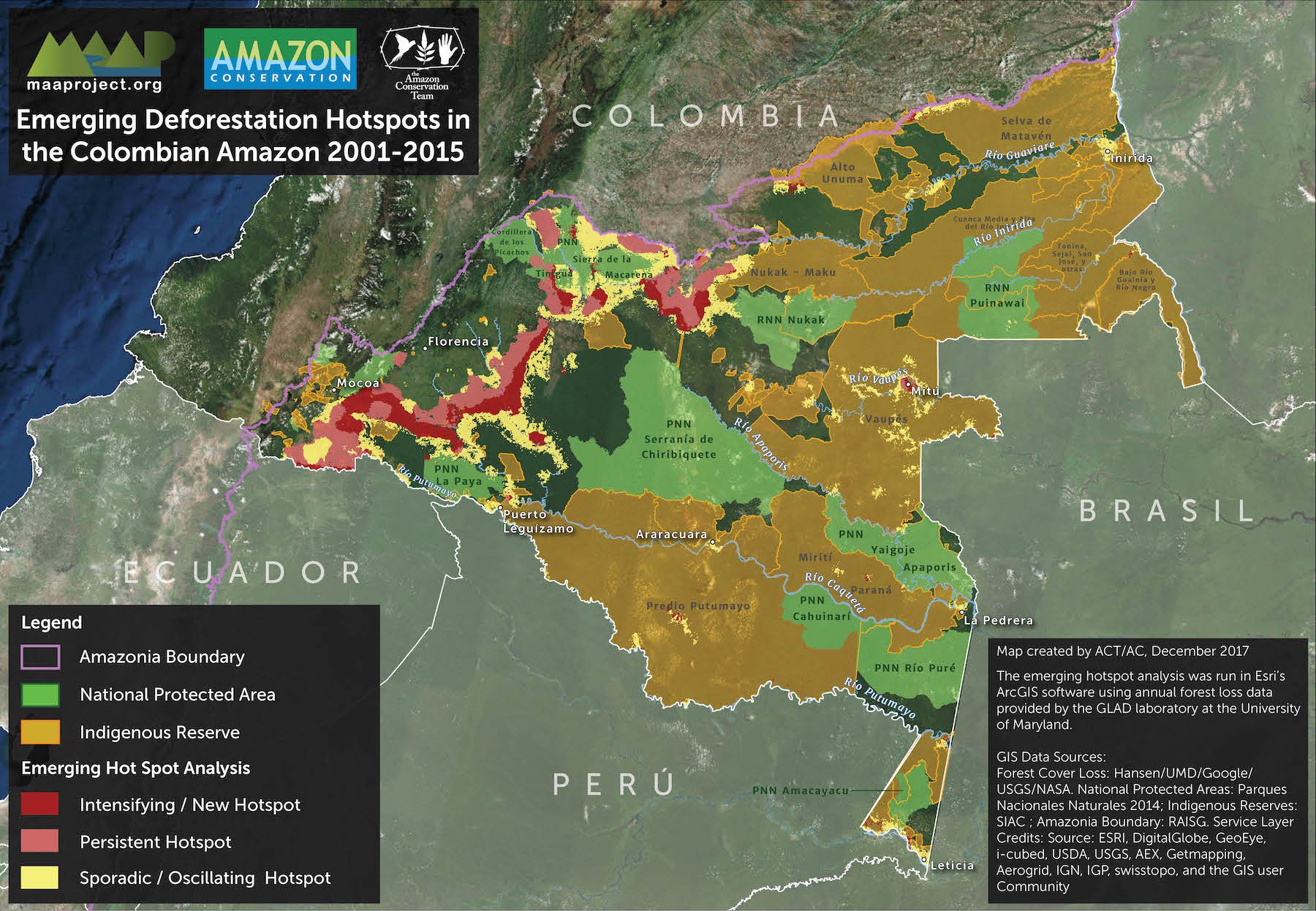
- An analysis of satellite data shows incursions into La Paya National Park in southern Colombia.
- The data indicate La Paya lost around 9,500 hectares of rainforest between 2001 and 2016.
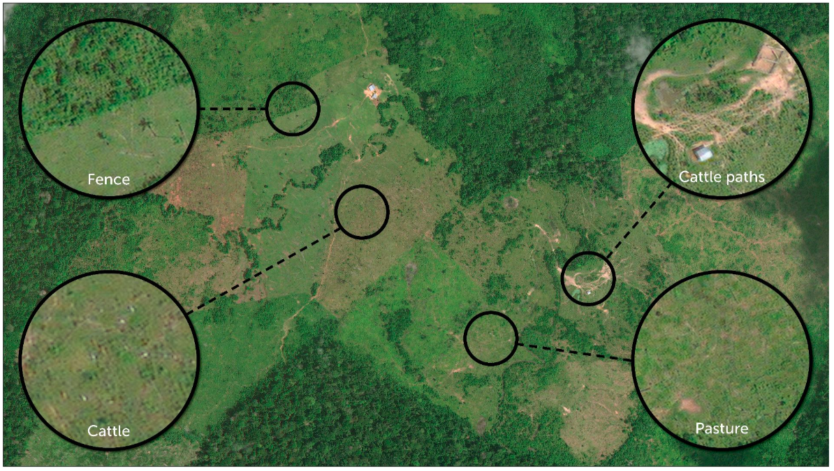
- Researchers say satellite imagery show evidence that these clearings are being used for cattle pasture.
- Conservationists worry deforestation will continue to rise with the demobilization of Colombia’s FARC rebel group, whose presence in the country’s forests kept logging and agriculture at bay for decades.
La Paya National Park sits on the edge of the Amazon rainforest along southern Colombia’s border with Ecuador and Peru. It comprises more than 4,200 square kilometers (1,620 square miles) and forms a green oasis in the largely denuded landscape that surrounds it to the west and north. Within La Paya live manatees, river dolphins, wooly monkeys, giant anteaters and many other Amazonian animals.
But while La Paya’s inclusion in the country’s most stringent land protection category has afforded it comparative protection, its forests are still being lost to human encroachment. A recent analysis finds high levels of deforestation within and around the national park, and researchers say cattle ranching is largely to blame for the intrusion.

The analysis was conducted by researchers at the Monitoring of the Andean Amazon Project (MAAP), which uses satellite imagery to examine deforestation in Amazonian countries. For this analysis, they looked at tree cover loss data compiled by the University of Maryland (UMD) from 2001 through 2016. Within that time period, they found deforestation within La Paya National Park occurred in fits and starts until 2010 when it starting rising sharply, culminating in a peak in 2014. The forest monitoring site Global Forest Watch, which visualizes the UMD dataset, shows La Paya lost 1,195 hectares of tree cover that year.
The data indicate deforestation within the park eased slightly in 2015, with around 780 hectares lost. But since then it’s been picking back up, with around 1,200 hectares of tree cover loss in 2016 and 2017, according to MAAP.

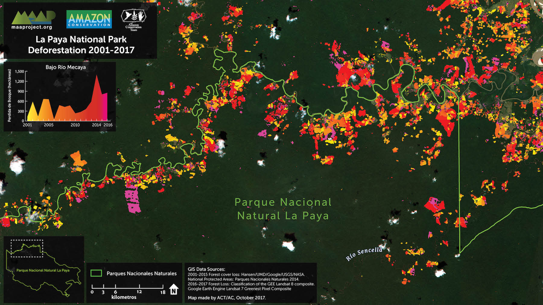
In total, the UMD data indicate La Paya lost around 9,500 hectares of tree cover between 2001 and 2017. Of that, 1,420 hectares – 15 percent – was lost from the park’s Intact Forest Landscapes (IFLs), which are areas of primary forest and other original landscapes that are undisturbed, connected and large enough to support all their native plant and animal communities. The loss of La Paya’s IFLs is far from unique; a study published last year found 7 percent of the world’s IFLs were destroyed or degraded between 2000 and 2013.
The MAAP researchers then zoomed in on specific areas of deforestation within La Paya to try and figure out what was causing it. They found broad swaths of new grassland, meandering paths, straight lines indicating fences and multicolored cow-shaped specks, which they write is evidence that cattle ranching is happening in the national park and likely responsible for much of its deforestation.
La Paya isn’t the only Colombian national park threatened by deforestation. In a previous analysis, MAAP charted the advance of forest loss towards nearby Chiribiquette National Park. According to UMD data, the expanding deforestation front is currently about 12 kilometers from Chiribiquette.
Overall, Colombia is experiencing an uptick in deforestation with UMD data showing the country lost more tree cover in 2016 than in any other year during the 2001-2016 study period. Conservationists worry deforestation will continue to rise with the demobilization of Colombia’s FARC rebel group, whose presence in the country’s forests kept logging and agriculture at bay for decades.
Citations:
Hettler B, Thieme A, Finer M (2017) Deforestation Patterns in the Colombian Amazon. MAAP Colombia: 2.
Hansen, M. C., P. V. Potapov, R. Moore, M. Hancher, S. A. Turubanova, A. Tyukavina, D. Thau, S. V. Stehman, S. J. Goetz, T. R. Loveland, A. Kommareddy, A. Egorov, L. Chini, C. O. Justice, and J. R. G. Townshend. 2013. “High-Resolution Global Maps of 21st-Century Forest Cover Change.” Science 342 (15 November): 850–53. Data available on-line from:http://earthenginepartners.appspot.com/science-2013-global-forest. Accessed through Global Forest Watch on February 8, 2018. www.globalforestwatch.org
FEEDBACK: Use this form to send a message to the editor of this post. If you want to post a public comment, you can do that at the bottom of the page.