
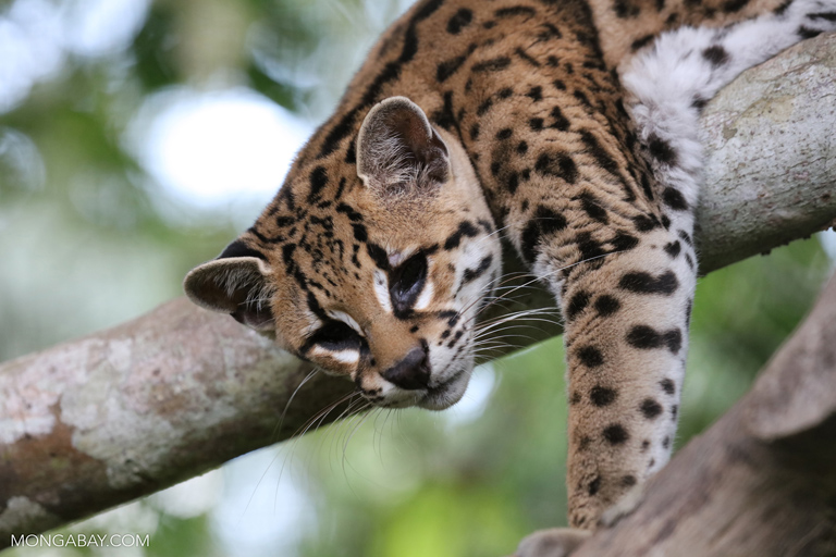
- A recent study used high-resolution satellite imagery to analyze deforestation events in Amazonia, uncovering a shift from large- to small-scale deforestation events across the region. Protected areas also appear to be affected.
- The results indicate big new deforestation hotspots are opening up in Peru and Bolivia, likely caused by industrial agriculture.
- The researchers found 34 percent of forest loss patches in the Brazilian Amazon were smaller than 6.25 hectares, which is the smallest size detectable by the Brazilian government’s deforestation monitoring system.
- The researchers say higher-resolution monitoring systems are needed to combat the rising tide of small-scale deforestation.
A new study finds small-scale deforestation in the Amazon rainforest has been increasing over the past decade, with new hotspots emerging in Bolivia and Peru. The news somewhat dampens Brazil’s touted successes at combatting deforestation, with researchers saying the country’s forest monitoring system is not capable of detecting small areas of forest loss.
Over the past decade, numbers from Brazil’s National Space Research Institute (INPE) have have shown big drops in deforestation in the Brazilian Amazon. After a spike of around 27,000 square kilometers of forest lost in 2004, INPE data indicate deforestation declined precipitously to less than 5,000 square kilometers in 2012. Since then, the data show deforestation in the region has remained relatively low compared to years past, with experts attributing the decline largely to the strengthening of environmental regulations in the mid-2000s.
However, Brazil’s drop in deforestation may not be quite as big as those numbers suggest. INPE uses a satellite monitoring system called PRODES to look for tree cover loss in the Amazon, a system that has been lauded by conservationists as a big force behind the deforestation decline in the Brazilian Amazon. But PRODES can only detect canopy gaps larger than 6.25 hectares, meaning that deforestation events smaller than that may be missed.
To get a more comprehensive look at deforestation trends in the Amazon rainforest, a team of scientists from the UK and Brazil used another satellite monitoring dataset, one that can detect tree cover loss at a much smaller resolution. Produced by the University of Maryland, this Global Forest Change (GFC) dataset can detect losses in tree cover at a scale of 30 meters. Their results were published recently in Nature’s Scientific Reports.
Using the GFC dataset, the team looked at deforestation events across Amazonia that happened between 2001 and 2014, finding that the vast majority – 96.4 percent – of forest loss patches were smaller than 6.25 hectares. Brazil and Bolivia were the only Amazon countries where their respective average patch sizes were larger than 1 hectare. Brazil’s average patch size was 15.6 hectares, but the team found it has been declining since 2004. The researchers write that this shrinking average patch size means that large-scale deforestation events are declining and small ones are on the rise.
In total, the data indicate 34 percent of forest loss patches in the Brazilian Amazon were smaller than 6.25 hectares. In other words, the study found that more than a third of deforestation events that happened in Brazil’s rainforests between 2001 and 2014 may have been too small to be detected by the PRODES monitoring system.
The team also uncovered some specific trends underway in the Amazon. First, Brazil’s notorious “arc of deforestation” – a massive belt of forest loss that spans the country’s midsection – appears to be slowing. The data show there was less tree cover loss in this region in 2008-2014 than in 2001-2007.
The study also reveals new deforestation hotspots are developing in Bolivia, Peru and, to a lesser extent, Colombia. The Bolivian hotspot, which lies in the states of Santa Cruz and Beni, appears to be the biggest and most intense. With around 300 square kilometers of tree cover lost in 2001-2007, deforestation rapidly increased in 2008-2014 to approximately 9,560 square kilometers.
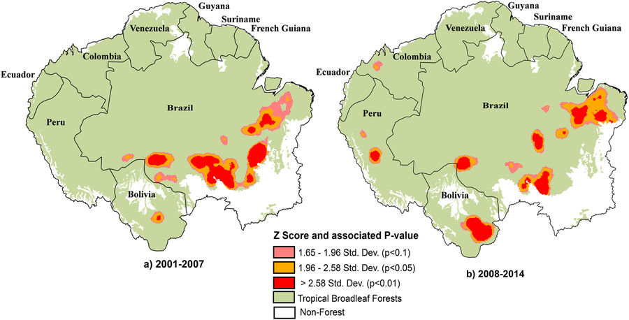
In Peru, the GFC data show a fresh hotspot of forest loss in the central part of the country that emerged only in the second half of the study period. Here, the data indicate 2,066 square kilometers of forest loss between 2008 and 2014. Colombia also has an emerging deforestation hotspot near its border with Ecuador and Peru.
In their study, the researchers write that Peru’s new deforestation hotspot is likely due to an uptick in palm oil production in the Ucayali and San Martin regions. In Bolivia, they also point to industrial agriculture – specifically soybean cultivation driven across the border by Brazil’s soybean moratorium.
As for Brazil’s big uptick in small-scale clearing, the researchers write that their results support previous research that indicate an increase in smallholder deforestation. But they say that it may also “partially reflect attempts by larger landowners to evade monitoring of deforestation activities.”
The study found little refuge from this trend of rising small-scale deforestation, with similar increases both inside and outside protected areas.

“These small-scale losses in forest cover now present a new and alarming challenge for conservation efforts in Amazonia, as they are inherently more difficult to monitor and control,” the researchers write. “Protected areas are seen as a cornerstone for reducing deforestation and carbon emissions. Our results suggest that the management strategies of Amazonian protected areas may need revising to account for the increasing threat of low-density, small-scale forest losses.”
In their study, the researchers write that the 6.25-hector resolution of the PRODES system is not enough, and strongly recommend that Brazil implement a year-round, higher-resolution dataset to combat deforestation.
“Altogether these results raise awareness of new threats that national-level statistics do not capture and pose new challenges for conservation of Amazonian forests.”
Citation:
Kalamandeen, M., Gloor, E., Mitchard, E., Quincey, D., Ziv, G., Spracklen, D., … & Galbraith, D. (2018). Pervasive Rise of Small-scale Deforestation in Amazonia. Scientific Reports, 8(1), 1600.
FEEDBACK: Use this form to send a message to the editor of this post. If you want to post a public comment, you can do that at the bottom of the page.