
- For those who regularly use Guyana’s Linden-Lethem trail for work, trade, or visiting family, it’s a source of constant frustration.
- An 80-mile section of the road, stretching from Linden to Mabura Hill, has been earmarked for rehabilitation.
- The Caribbean Development Bank has just approved a grant of $1.06 million to the government of Guyana to fund a feasibility study for the project.
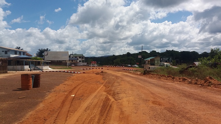
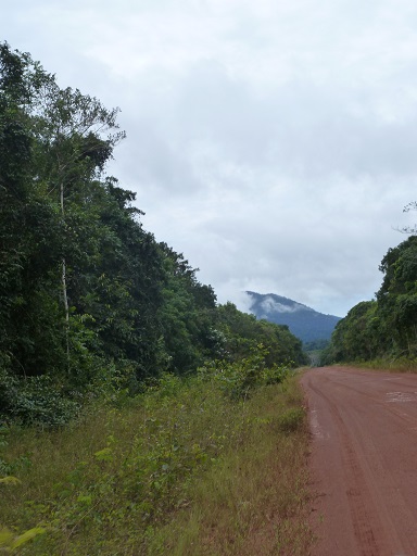
GEORGETOWN, Guyana – Imagine for a second you’re on a road. A long, rough, red-dirt road lined by thick rainforest. You’re in a small, crowded minibus coming from Georgetown, Guyana’s coastal capital on the Atlantic Ocean, and heading for Lethem on the southern border with Brazil. For the first couple of hours, up until the once-flourishing Bauxite-mining town of Linden, the road was paved and progress was quick. But now the bus is moving in fits and spurts, lurching left and right to avoid the giant potholes that have been gouged in the road by passing trucks, groaning under the weight of freshly timbered trees.
The driver plays reggae soca, Brazilian forró music – anything to stay alert as night begins to fall. Eventually the bus reaches the wide Essequibo River, but you can’t cross it until 6am when the floating pontoon starts operating. Once you do make it over, there’s more forest to pass through, followed by mountain-fringed savannah, before you finally emerge bleary-eyed in Lethem in time for a late breakfast or early lunch.
For the intrepid traveler, it’s an adventure. For those who regularly use the Linden-Lethem trail for work, trade, or to visit family, it’s a source of constant frustration. Especially during the rainy season when some bridges and sections of the highway are barely passable or wash away entirely – as has been the case in recent weeks.
“I saw this road get so bad…sometimes we [would] cover two kilometers [1.2 miles] in nine hours,” said Colin Jarvis, who lives along the road in the village of Surama and has been a driver for the Iwokrama International Centre for Rainforest Conservation and Development for almost 20 years. “We need to have a good road, a proper road.”
Jarvis may be about to get his wish – up to a point. An 80-mile section of the road, stretching from Linden to Mabura Hill, has been earmarked for rehabilitation. The project is being funded by the United Kingdom Caribbean Infrastructure Partnership Fund (UKCIF) and administered by the Caribbean Development Bank (CDB). A bridge is also planned to replace the pontoon crossing at Kurupukari and provide 24-hour access over the river.
At the time of publication, CDB’s board of directors had just approved a grant of $1.06 million to the government of Guyana to fund a feasibility study for the project. According to Andrew Dupigny, Head of Infrastructure Partnerships at the CDB, the technical assistance provided will include a full Environmental and Social Impact Assessment, plus a Climate Vulnerability Assessment.
Talk of fixing the road is nothing new in Guyana, where previous promises and feasibility studies have evaporated into thin air – usually due to lack of financing to actually carry out the work. There was the 2000 ADK/Gibb Feasibility Study funded by the European Union, the 2008 Mott MacDonald/CEMCO Pre-Feasibility Study funded by the Inter-American Development Bank (IDB), followed by another IDB-funded feasibility study in 2012 carried out by SNC Lavalin.
But there is optimism that this time things will be different.
“I give myself [until] early-mid next year [when] work should commence,” said Geoffrey Vaughn, coordinator and chief works officer at Guyana’s Ministry of Public Infrastructure.
Funding is also being sought for the remaining section of the road, from Mabura Hill to Lethem, and the government is in discussion with different prospective investors, including the Islamic Development Bank, China and Brazil. Following the 2009 installation of the Takatu Bridge, connecting Lethem with Bonfim in Brazil, then-Brazilian president Luiz Inácio Lula da Silva pledged to support the paving of the Linden-Lethem road, which in turn would open up opportunities for Brazil to trade out of Georgetown’s coastal port. In a recent meeting, Brazil reaffirmed its commitment.

According to Vaughn, the rehabilitation of the road will include replacing the current all-weather laterite surface (laterite is a clay-like material found along the highway), which he noted hasn’t always been maintained as well as it should have due to lack of proper funds and supervision. “We are moving towards making it asphalted concrete,” he said. “However laterite can still be used as a base course or sub-base material, once it passes all the tests.”
Environmental impact
When work on the original road began back in 1989, concerns about its potential impact were raised by certain groups, including Survival International and the Guyana Human Rights Association, according to an article in the 1994 edition of The Ecologist. In the piece, Malcolm Colchester, now a Senior Policy Advisor with Forest Peoples Programme, made a dire prediction: “The completion of the road will lead to the invasion of Guyana by landless settlers, miners, timber cutters, urban squatters and drug smugglers.”
Despite such warnings from Colchester and others, exploring the potential environmental and social impacts of the road seemed to be low on the government’s priority list at the time.
“No EIA [environmental impact assessment] or social surveys were carried out,” said Colin Edwards, who was responsible for government negotiations concerning the road at the time and now runs Rock View Lodge, a guesthouse located off the highway near Annai. He noted, however, that approval for the construction and routing of the road was obtained from local village councilors and officials, including then-Regional Chairman Patsy Fredericks and Annai District Toshao (or village leader) Sydney Allicock, now Guyana’s Minister of Indigenous Peoples Affairs.
But fast-forward 28 years, and the picture has changed.
“Engineers will need to consult with NGOs like Iwokrama and the NRDDB [North Rupununi District Development Board],” Edwards said. “Besides of course WWF and CI [Conservation International].” And thanks to Guyana’s Environmental Protection Act, passed in 1996, the government has a legal duty to do so.
“Should the developer – in this case, the government Ministry of Public Infrastructure – find that the road is feasible and wish to proceed with the building of the road, an application must be made to the EPA [Environmental Protection Agency] for environmental authorization,” said Kemraj Parsram, executive director of the EPA.
This application will require a feasibility report, detailed project summary, and most likely an environmental and social impact assessment.
Vaughn doesn’t see this causing any serious headaches for the Ministry of Public Infrastructure.
“In terms of the environmental aspect of it, I don’t think there’ll be many environmental issues along those [road] corridors,” he said. “We’re not working as a standalone agency; we have our EPA, we have the Guyana Geology and Mines Commission on board with us, we have the wildlife people on board … because these are some of the conditions that are laid down.”
For a project of this scale, said Parsram, it is likely that permission will be granted in phases.
“The nature of this project would require that the EPA implement a monitoring schedule as it has done for other large-scale projects,” he said. He also emphasized the importance of public and non-governmental organizations, for example in reporting any bad environmental practices as the project progresses.
However, while the environmental safeguards come across strong on paper, the reality is more complex. For starters, Guyana’s EPA is said to be sorely understaffed. According to an article last year in the local Stabroek News, an audit of the EPA published in 2016 found just 27 staff working in environmental management compliance – less than a third of the number said to be needed. This means that if the road’s developers fail to comply with the conditions of their permit, the EPA may struggle to carry out the necessary enforcements. Improving the quality of the road is also likely to increase other activities which partly fall under the EPA’s remit, such as illegal gold mining, logging, hunting and fishing.
Under such a heavy workload, the EPA may have to rely more on local stakeholders and NGOs than even Parsram realizes.
Protecting the wildlife
In 1989, the same year that construction first began on the road, a 371,000-hectare reserve was established in Guyana. Since 1996, this forest has been managed by the Iwokrama Centre – including the 45-mile section of the Linden-Lethem road that falls within its boundaries. It’s hoped that Iwokrama’s community-centered approach will provide something of a model for how the newly rehabilitated road could be managed.
“We have checkpoints at both ends,” said Adit Sharma, Iwokrama’s Monitoring Manager. “Management of the road and security also means collaboration with law enforcement agencies like GGMC [Guyana Geology And Mines Commission], police, the Ministry of Public Infrastructure, as well as community members, who are the people most affected by these things and we depend on them for information.”
This multi-faceted approach has helped Iwokrama to hone in on illegal activity in the area including intercepting incidents of wildlife trafficking, ranging from songbirds and macaws to large mammals.
“We apprehended a vehicle carrying a jaguar, a cub and a couple of other wild animals here,” Sharma said. “That was reported to the wildlife authority and dealt with accordingly.”
Iwokrama’s rangers also follow a biophysical monitoring framework on their patrols. This involves collecting data from wildlife sightings, bird transects, road kill, and roadside burrow pits; as well as monitoring water quality in the creeks and at road crosses.
Because of the center’s considerable experience and database, Sharma feels Iwokrama is well placed to contribute to the road’s design – and he has a number of ideas about how to improve animal safety on the road including underpasses, overpasses and fences that funnel animals into a particular path.
“These designs have been implemented in various parts of the world, so we’re not just talking airy-fairy things,” Sharma said. “We have a wonderful [clean] slate to work with because we’re pretty much at the start.”
Without such safety considerations, increased road kill is inevitable. In collaboration with Conversation International Guyana, Panthera researcher Evi Paemelaere monitored a stretch of road in the Rupunini savannah and found the most common road kill to be foxes. However, she said, “The species that we feel is going to be most threatened by any improvements of that road in terms of road kill is the giant anteater, which is really bad because tourism depends also on [their] presence.”
Already a threatened species, she explained, anteaters are slow at spotting danger, they don’t avoid the road and are slow reproducers – increasing the risk of population decline.
This would explain why the species ranks high in mortality lists of roads, particularly where roads cross savannahs. Their slow reproduction rate makes it impossible to quickly replace the individuals killed, aggravating the risk of notable population declines.
Paemelaere and her colleagues presented their findings to the Ministry of Infrastructure in March 2017, along with three key recommendations: good hunting regulations; zoning for separate stretches of road for animal and human use; and strong bridges to prevent erosion, avoid water pollution and provide more space for crossing. She notes with optimism that the ministry has purchased scales to weigh freight and ensure trucks are not overloaded.
Other affected species could include the spider monkey. “They’re very sensitive to disturbance already,” she said. “How crossable is this road going to be for them?”
Ultimately she feels that stronger enforcement action is needed, as well as more research by conservation agencies – ironically two things that may be made easier, and cheaper, by the improved road.
“There’s a lot of information they’re missing, for example we don’t know very well which species may be avoiding the road and that’s a big issue because if they don’t cross at all then you create a genetic barrier,” Paemelaere said. “For conservation purposes that’s probably the worst that can happen.”
Local knowhow
One way to capture more data along the road is community monitoring, and a project to encourage this is already in its second phase.
“Over 50 young people have been trained in the use of smartphones and a simple reporting card to monitor their own resources,” said Vanda Radzik, an independent consultant and social activist. It’s just one of many ideas noted in the Indigenous Peoples Plan for the road, which Radzik produced as part of the 2012 IDB feasibility study. “In essence, what the plan focuses on is a community road zone – like a managed road corridor from Surama, the first village of Annai; down to Toka, which is the last of those communities of the North Rupununi that’s on the road.”

Other local suggestions documented in the plan include speed limits, speed bumps, and safe road crossings, barriers at the beginning and end of each road ‘zone’, an accident & emergency ward at Annai Hospital and ambulances at Kurupukari and Annai, and dedicated paths for walking and cycling to avoid accidents. Adequate culverts under bridges or passages in fish-spawning areas, traffic police training for local young men and women, and a road-safety course have also been suggested.
“At one of the meetings,” Radzik recalled, “the people said: ‘We don’t want the road to just be an ugly scar, because our landscape is so beautiful.’” Their proposal? A corridor of trees beginning where the forest becomes savannah.
The critical task will be getting suggestions adopted by the EPA and other government agencies. This will involve contributing to public consultations, particularly concerning the EPA’s Environmental Social Impact Assessment of the planned road improvements.
Despite concerns around everything from loss of indigenous culture and natural resources, to harmful “coastal influences” and increased trafficking of persons, there’s a sense that although progress is inevitable, the negative impacts don’t have to be. Increased domestic tourism, for one, could bring new sources of income.
“With the cost of airline tickets, many Guyanese are not motivated to travel to the Rupununi,” said Candace Phillips of Visit Rupununi “With a better road, this [area] may see some growth.”
The challenge will be in getting the balance right. Or as Minister Allicock – a long-standing champion of indigenous rights and culture, and the same former Toshao who once gave his nod to the construction of the road – is quoted as saying: “Let us prepare ourselves to use the road, wisely and well, so that the road does not use us.”
Banner image: A truck brings supplies from Georgetown along the Linden-Lethem road. The cost of bringing in goods to the villages lying off the road, mining camps or Lethem itself makes them more expensive than in the capital. Photo by Carinya Sharples/Mongabay.
Carinya Sharples is a Guyana-based foreign correspondent. You can find her on Twitter at @carinyasharples
FEEDBACK: Use this form to send a message to the author of this post. If you want to post a public comment, you can do that at the bottom of the page.