
- A team of scientists from the Carnegie Institution for Science found that, between 1999 and 2016, gold mining expansion cost the region 4,437 hectares (10,964 acres) of forest loss per year.
- Miners were working an area in 2016 that was 40 percent larger than it was in 2012.
- The findings, along analyses by ecologists at the Monitoring of the Andean Amazon Project, indicate that increased enforcement by the Peruvian government has slowed the rate of deforestation.
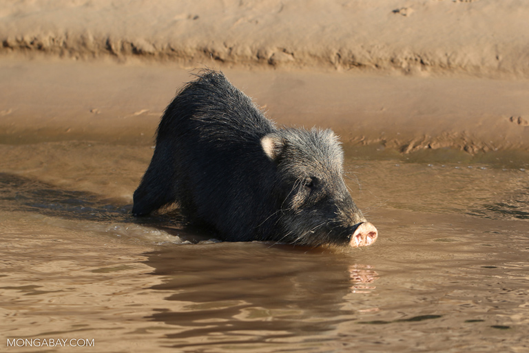
Tambopata National Reserve is a haven for plants and wildlife, not to mention ecologists eager to understand the mysteries of the forest in this corner of the Peruvian Amazon.
“It’s just seething with species,” said Greg Asner, an ecologist at the Carnegie Institution for Science at Stanford University. “It’s a place where I’ve seen jaguars swimming across rivers and huge amounts of fauna.”
But for nearly two decades, this “epic landscape” in the region of Madre de Dios has been under threat: Gold miners have moved into the reserve’s buffer zone and even the reserve itself, leaving bare land stripped of forests and topsoils in their wake. In a study published Tuesday in the journal Environmental Research Letters, Asner and his team demonstrate that, despite interventions by the Peruvian government, the push for gold has not relented.
“Gold mining to me is the most extreme assault you can make on the Tambopata Reserve and its buffer zone,” he said in an interview. “It’s a blunt assault on nature in that reserve.”
In a previous study published in 2013, he and his colleagues cataloged that destruction between 1999 and 2012. They discovered that the area devoted to gold mining in Madre de Dios in 2012 was four times what it was in 1999, often tracking spikes in the price of gold over that time period.
This new study picks up where the last one left off, extending Asner’s unique approach that centers on airborne forest monitoring. As they fly transects back and forth over the rainforest, a sensor called a spectrometer mounted on the team’s airplane measures the subtle differences in how chemicals in the canopy reflect light.
When they look at that data in concert with images from NASA’s Landsat satellites and analyzed it with their own deforestation and degradation mapping software called CLASlite, they can pick out even small disturbances to the forest cover down to 10 square meters, or about 107 square feet. That includes the small — yet still destructive — mines that were previously invisible to scientists and Peruvian authorities.
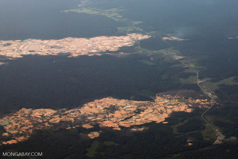
The current study shows that, between 1999 and 2016, gold mining expansion cost the region an average of 4,437 hectares (10,964 acres) of forest loss per year, and the area it covered in 2016 was 40 percent larger than it was in 2012. Asner was also curious about the impact that the government’s crackdown on illegal gold mining had had a few years ago.
“They did a full-court press in 2012 to reduce gold mining,” he said. The team’s analysis showed that it was successful, at least for a time: “There was a downward blip after 2012, but it just came right back in full force after 2012.”
The resurgence of deforestation indicate that a longer-term effort on the part of the government will be necessary to stop the destruction from mining, Asner said.
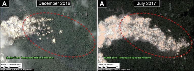
There are signs that the government is committed to removing this threat. In September 2016, government officials began to be “much more aggressive about removing miners from within Tambopata,” said Matt Finer, an ecologist with Monitoring of the Andean Amazon Project, or MAAP, in an email.
It seems to be working: “Recent satellite imagery shows an important lack of new deforestation expansion within the reserve,” Finer said.
Still, gold mining has proven to be a persistent problem, despite moves by authorities to stamp out mining in this reserve. In July, they carried out a “major raid” in Tambopata’s buffer zone.
However, “That effort seems less successful as recent imagery still shows extensive mining camps in the area,” Finer said.
The Lima-based newspaper El Comercio reported in July that the miners’ temporary settlements are centers for “human trafficking, sexual exploitation [and] torture,” in addition to the damages to the environment.
Asner explained the buffer zone was originally set aside to allow indigenous groups to continue using the forest and its resources as they have for centuries. At the same time, the plan was to introduce other ways to allow them to benefit while safeguarding standing forest, such as ecotourism.
Many consider the continued incursions into the buffer zone, largely by outsiders, to be an affront to the livelihoods of these local peoples. Moreover, it’s likely that the negative impacts of gold mining — even mining that’s contained within the buffer zone — could ripple downstream.
“All of the detection we’re doing does not resolve the really big additional effect of hydrological pollution from the sediments and from the mercury that’s used in the mining process,” Asner said.
Mercury bonds with gold, helping miners extract it from the sediments. It’s also a toxic element that can have devastating effects on fish and wildlife populations that have made Tambopata such an important place to protect.
“It’s not a very big assumption to say that that gold mining is now polluting the river system down through … the actual Tambopata Reserve,” Asner said.

CITATIONS
Asner, G. P., Llactayo, W., Tupayachi, R., & Luna, E. R. (2013). Elevated rates of gold mining in the Amazon revealed through high-resolution monitoring. Proceedings of the National Academy of Sciences, 110(46), 18454-18459.
Asner, G. P., & Tupayachi, R. (2016). Environmental Research Letters, 12, 094004.
Banner image of jaguars (Panthera onca) along the Tambopata River by Rhett A. Butler / Mongabay.
FEEDBACK: Use this form to send a message to the author of this post. If you want to post a public comment, you can do that at the bottom of the page.
Follow John Cannon on Twitter: @johnccannon