
- In this second of the Mongabay-Wildtech series on “What is that technology?” we examine radio telemetry, in the form of electronic tags used to monitor animals as they move about their daily lives to better understand how far they travel, what environments they use, and how to keep them safe.
- Radio-based tags and satellite-based tags, which include GPS tags, all communicate via radio signals but differ in how the signals communicate, the information they provide, and the energy needed to produce them.
- UHF and VHF radio tags–described in this post–are cheap, small, light, and long-lasting, but require human presence to receive the signals and locate the animal.
- Scientists can compile these point locations to map species’ local distributions, identify home ranges and migration patterns, and compare these with locations of water, food species, or human activity.
Why track wild animals?
How do wildlife biologists know where animals go and the resources they use? They watch them over sometimes extended periods. For millennia, people have watched animals on foot and noticed when they appeared, moved, and disappeared (think Serengeti wildebeest migration).
But what happens if an animal moves too far or too fast for researchers to follow? How do they know where it travels over a typical year – its home range? Or what if animals migrate, locally or across a continent, in response to say, a cold winter or a dry season? And when migrants return, how can the researcher tell if it is the same animal?
For that, researchers rely on radio telemetry technology, namely electronic devices, placed on the animal, that transmit information in the form of a radio signal. The signal from each telemetry tag is unique so the researcher knows which individual has been located, where it is, and various aspects of its condition.

Scientists track animals to see where they go – how far, how fast, in what direction and when, and whether they return. Modern telemetry equipment may also be used to monitor condition of the animal. By following a particular animal over time, scientists can record its location over various days or weeks or years to learn how far it travels in a day, month, or year.
By following several individuals of a given species, they can see repetition of behaviors that might be common for that species. With enough locations of enough individuals, for example, a researcher can build a map of the species’ distribution, identify the individual home ranges and migration patterns, and, compare these with other information, such as locations of water, food species, or human activity.
Precursors to radio tracking
Researchers initially monitored individual animals by attaching small metal or plastic tags to them, as ranchers do with their livestock. Color bands put on birds’ legs or uniquely numbered tags attached to deer’s ears or California condor’s wings allowed the researcher and others to spot the study animals and, if kind-hearted, report the sightings to the research project.

These tags are cheap and lightweight so they can be put on many individuals, and they last for years, allowing for long-term datasets to be generated. But spotting them requires clear repeated contact with the tagged animal, which is particularly difficult inside a forest or with wild animals that fear humans. The tags have no electronic components, so their color or number code and their location must be recorded manually, which limits how often they are sighted in the field.
What is radio telemetry?
In the late 1950s, researchers began experimenting with monitoring wildlife using electromagnetic radio signals put out by transmitters attached to individual animals. These small transmitters modernized wildlife study by allowing researchers to proactively search for radio-tagged individuals and detect their presence from a remote position.
The term radio telemetry refers to the monitoring of wildlife through automated transmission of information from a transmitter in one location to receiving equipment in another. Two main types of tracking tags make up the bulk of radio telemetry research. Radio-based tags and satellite-based tags, which include GPS tags, all communicate via radio signals but differ in how the signals are sent or received, the information obtained from the signals, and the energy needed to make the signals. This post provides background and describes radio telemetry; a follow-up article will explain the advances contributed by satellite technology.
What exactly is a radio tracking tag? And how does it work?
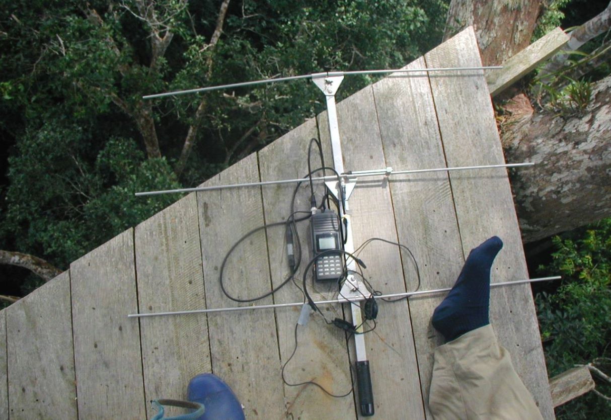
Radio transmitters are electronic tags that are placed on the animal and continually send out a radio signal that can be picked up by a receiver tuned to that frequency. Both Very-High Frequency (VHF, 30 MHz to 300 MHz) or Ultra-High Frequency (UHF, 300 MHz to 3 GHz) radio waves can transmit information in air and in fresh water.
The researcher tracks the pulsed signal – with its repeating “beep” or “ping” sound – using the receiver and a directional antenna, typically carried on foot, in a car, or in a plane. Each tag beeps at a particular frequency and, in some cases, at a specific pulse rate. Like tuning a car radio to a certain station (frequency), the researcher tunes the receiver to the respective frequencies of his/her tagged animals to hear the pings being “broadcast” by whichever tags are in the area.
The receiver picks up the signals and indicates the signal strength, which indicates to the operator when s/he is getting closer to the tag. Tags closer to the receiver sound louder, as do tags within line-of-sight of the receiver.
Signals are stronger when the antenna is pointing at the tag, so a researcher using a directional antenna can move the antenna from side to side to help determine the direction in which the signal is strongest. The researcher can turn down the “volume” (called the gain) as he or she gets closer the tagged animal to better pinpoint its location.
A receiver held near ground level must typically be within a few kilometers of the animal to detect the signal, while from an airplane detection distance can be up to 20 or more km. Researchers might also connect their receiver to an antenna on a tower to enhance detection distance.
Emitting simple pulses that travel short distances requires relatively little battery power, so VHF radio tags can be small (tags must be limited to <5% of the animal’s weight) and long-lasting, which makes them suitable for tracking birds or small mammals for months at a time. VHF tag electronics themselves are small (as little as 1 gram); most of their weight is attributable to its batteries. Being powered by batteries means that tracking tags must balance size, signal strength, and longevity. Tags with larger, heavier batteries will transmit for longer periods and with a stronger signal than those with small, light ones. Thus, scientists tracking migratory birds have traditionally been limited to a single season, whereas those monitoring bison or elk can set their tags to transmit for several years.
How do you put it on the animal?
Placing a tracking tag on a wild animal requires keeping it still and quiet. Merely covering a bird’s eyes can often calm it down, whereas large animals must usually be sedated. While the animal is calm or asleep, the research team fits the tag, turns it on, and records information about the health and condition of the animal.
The tag is held on the animal using a collar, ear tag, ankle bracelet, mini-backpack, or special adhesive. In some cases, such as with fish, transmitters are implanted to allow the animal to move freely underwater.
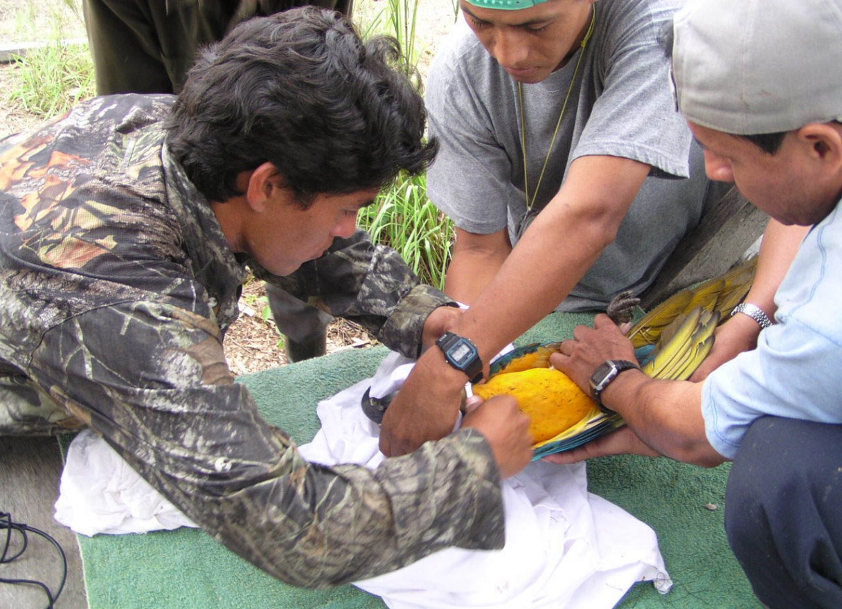
For long-lived animals, researchers will often construct the collar or bracelet with a drop-off device that allows the tag to fall off the animal on a particular date, freeing the animal of its unwanted jewelry once the tag has stopped transmitting.
What do researchers or managers do with the data?
Research teams can use the direction and strength of the signal to physically follow the subject and see where it goes, what it’s doing, and, if it is eating, what is on the menu? Other observations can include: what time of day is it active, is it resting, has it found a mate, or are there others of its kind in the same area?
When an animal cannot be located—in dense forest or across a river, for example—researcher teams use triangulation. This involves estimating distance and angle to a tagged animal from three different places and determining where lines drawn from each point would intersect.
Scientists can combine the point locations with other spatial data in a GIS to create maps of the animal’s whereabouts and their relationship to water, vegetation types, food trees, villages, or other tagged animals.
Using the accumulated point locations of several tagged animals, scientists can estimate home range sizes, habitat use, and travel distances per day, month, migration route or year.
With enough locations of enough individuals, a researcher can build a map of the species’ local distribution, identify the individual home ranges and migration patterns, and, compare these with other information, such as locations of water, food species, or human activity.

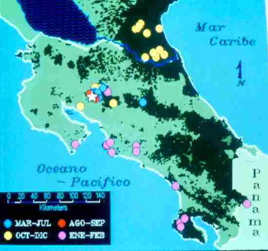
For example, researchers in Costa Rica found that radio-tagged three-wattled bellbirds migrated from lowland rainforests to higher-elevation cloud forests to dry forests, demonstrating the need for protecting several distinct forest types. Three species of macaw in Peru each nested in different types of trees, one of which was threatened by logging and another by gold mining.
Such efforts require substantial manpower, as obtaining point locations is typically a result of coordinated physical effort. Although VHF tags themselves are cheap, the main cost of this method is typically the time of researchers who must be present to tune in to the various frequencies. VHF radio tags help guide field researchers to a tagged animal, but they require researchers to determine each location manually, which is typically time consuming and thereby severely limits the number of point locations that can be obtained for a given animal.
Continued improvements in communication systems, including cell phone and satellite systems and the advent of GPS, have allowed expansion and automation of the use of radio wave technologies for tracking animals and will be the focus of our next “What Is That Tech…?” post.
Banner image is the Serengeti National Park wildebeest migration. Photo credit: Sue Palminteri