
- A new analysis of satellite data describes dozens of fires that invaded protected areas throughout northern Peru in the last few months of 2016.
- The rainy season has since extinguished the fires, but not before they burned through an estimated 2,668 hectares of protected habitat
- Representatives from Peru’s National Protected Areas Service (SERNANP) say they met the fires head-on and are working on ways to mitigate similarly severe fire seasons in the future, but critics say their efforts were lacking in 2016.
Wildfires in Peru have burned through an estimated 2,668 hectares (27 square kilometers) of protected habitat in northern Peru, according to a report released last week by Monitoring of the Andean Amazon Project (MAAP). The researchers suggest that intense drought – coupled with poor agricultural practices – are implicated in the recent outbreaks.
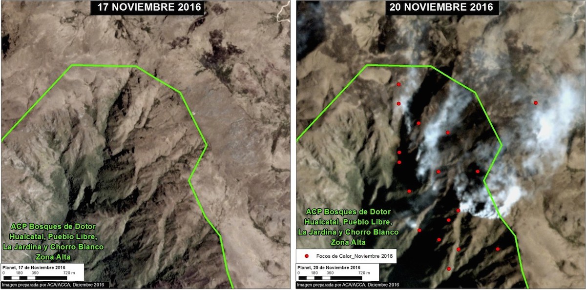
Using a combination of high-resolution satellite imagery and data from NASA’s Fire Information for Resource Management System (FIRMS), MAAP detected wildfire deforestation within 11 reserves that decorate the country’s northern states.
“Recent burn areas show up pretty clearly in high-resolution imagery, so it is possible to draw polygons around these areas and calculate area,” Matt Finer, lead author of the analysis, said in an email to Mongabay.
The majority of these areas are nationally owned and administered, such as wildlife refuges, sanctuaries, and national parks, but MAAP also recorded burn scars within protected areas that are administered privately or at the municipal level – those similar to state parks in the U.S.

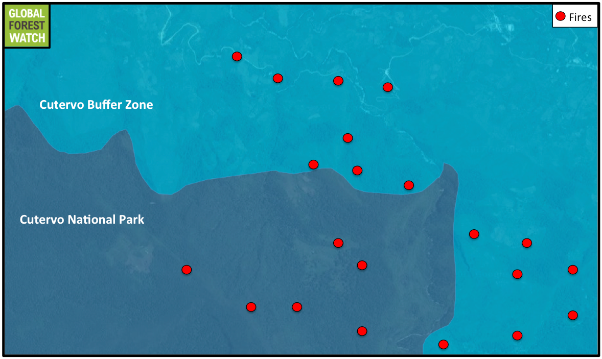
According to one regional expert, the wildfires – which picked up in September – were likely ignited somewhere outside the protected area boundary, where fire prevention is weak.
“The fires often start in the buffer zone [an area that surrounds some reserves] and then spread to the protected area,” José Luis Capella, Forestry Program Director at the Peruvian Society of Environmental Law (SPDA), told Mongabay. “When they spread, you can’t control them.”
MAAP’s estimation of total wildfire deforestation in northern protected areas replaces their previous estimate – announced last month – of 1,500 hectares. The new number reflects more accurate and comprehensive measurements, Finer said.
Wildfires in nationally owned, nationally managed protected areas
Wildfires consumed nearly 1,700 hectares across seven national protected areas administered by the National Protected Areas Service, SERNANP. These include: Cutervo National Park, Cerros de Amotape National Park, Tabaconas-Namballe National Sanctuary, Laquipampa Wildlife Refuge, Pagaibamba Protected Forest, Tumbes National Reserve, and Udima Wildlife Refuge.
Peru’s very first protected area, Cutervo National Park, lost around 300 hectares of forest in the wake of recent wildfires. Established in 1979, the park protects the Caves of San Andres de Cutervo – home to colonies of the unique, echo-locating oilbirds (Steatornis caripensis) – and a slew of rare species, including the spectacled bear (Tremarctos ornatus) and mountain tapir (Tapirus pinchaque).

Wildfires also tore through the Amotape mountain range, home to Cerros de Amotape National Park and Tumbes National Reserve. The MAAP team documented 520 hectares of habitat consumed by fire across these protected areas. Located in the transitional zone between Equatorial Dry Forest and Pacific Tropical Forest, this region is inhabited by many endemic species – meaning they’re found nowhere else in the world.

Wildfires swept through rare ecosystems, as well.
Pagaibamba Protected Forest and Tabaconas-Nambelle National Sanctuary surround habitats known as “páramos” – landscapes uniquely situated between the continuous timberline and the permanent snowline, to which rare plants and animals have adapted. The wildfires slashed through Pagaibamba and Tabacanas-Nambelle, razing 424 hectares across the two reserves.


The fires also consumed tracts of Seasonally Dry Northwest Forests, which the MAAP team writes are “one of the most threatened ecosystems in Peru.” Laquipampa Wildlife Refuge, one of the few remaining strongholds of these systems, experienced a loss of over 100 hectares.
Wildfires in other protected areas
Fires razed an additional 780 hectares across three private conservation areas: Chicuate-Chinguelas, Huaricancha, and Bosques de Dotor. These areas – which are managed by private landowners – include ecosystems that are “important for regulating water resources in the Amazon headwaters,” MAAP’s previous analysis states.
MAAP also reported that the municipal conservation area, Cachiaco Environmental Conservation Area, lost over 200 hectares of tree cover. Although this area is not considered part of Peru’s national protected area network, it contains important páramo and montane habitats.
A severe 2016 fire season
MAAP’s analysis provides but a few examples of Peru’s devastating 2016 fire season. By November, fires had razed tens of thousands of hectares of forests, damaged important crops, and took the lives of two people. The government declared a state of emergency for several northern districts in response to some of these events.
“In the first place, because of the magnitude of the fire’s reach, the government has declared a state of emergency in the zones affected by the greatest intensity and risk,” Prime Minister Fernando Zavala said in November, according to Democracy Now!. “This will permit the national government to continue mobilizing people, resources and diverse equipment in order to confront these fires and attend to the population that has been affected.”
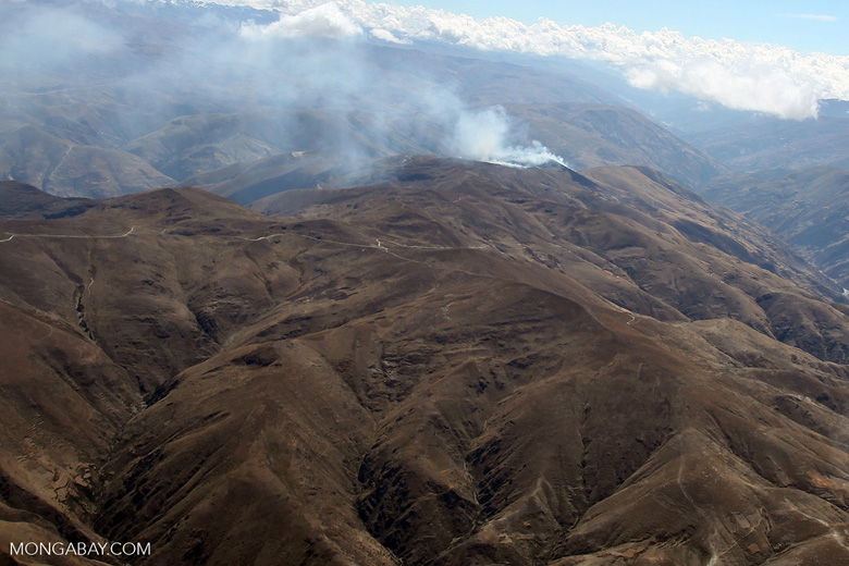
A combination of a 10-year drought and the widespread use of slash-and-burn agriculture – where vegetation is cut down and burned to clear land for cultivation or pasture – drove the fire events, according to MAAP.
And fire experts agree. Henrique Costa, a professional geographer and volunteer firefighter, said that unusual climate conditions – driven, in part, by climate change and an El Niño event – delayed the onset of the rainy season. Without rain, the forests dried out, leaving them primed for ignition by practices like slash-and-burn.
“The difference between this year and other years is that the forest was so dry, that when people start fires for…agricultural practices, they spread very quickly and get out of control,” Costa said in an email to Mongabay. “And why [is the wood] so dry? Climate change and El Niño delayed the beginning of the rainy season.”
Slash-and-burn agriculture is illegal across Peru. But it’s not well regulated, if at all, Capella said.
“[Slash-and-burn agriculture] is prohibited, but also not regulated,” he said. “No one is enforcing the law to stop fires.”

According to Capella, this year is another example of how the government has yet to prioritize wildfire mitigation in Peru. And it’s not just about better regulations, he said; faster response times and stronger management techniques are needed, as well.
“We don’t have a specific strategy to respond to these fires,” he said. “Sometimes the [government] response was three or four days after the fire, but sometimes it was many weeks after.”
Costa complained to the same tune.
“The state authorities just don’t have the knowledge, the equipment, or resources to fight forest fires,” he said.
SERNANP is responsible for fire mitigation within Peru’s national protected area system – some 67 areas that encompass more than 19 million hectares across the country. While the state agency employs hundreds of park rangers that control illegal activities, only a handful of them are trained firefighters, Capella said.
In an interview with Mongabay, SERNANP officials acknowledged limitations in equipment and the “great scope of action” they face – referring to the amount of land they oversee. But they also made mention of the agency’s leadership in confronting fires that tore through protected areas last year.
“We have spearheaded efforts to confront those events that happened inside protected natural areas,” Deyvis Huamán, an official in SERNANP’s management division, told Mongabay. “Forest fire mitigation requires a high degree of specialization, and I believe we have been the…first ones in the country to have adequate personnel and equipment for the confrontation of forest fires.”
According to Huamán, SERNANP has about 50 park rangers that focus on fire prevention and control across the country. The problem of wildfires last year, Huamán said, was not SERNANP’s deficient response times. Instead, drought and poor agricultural practices that caused “a series of extraordinary events with extraordinary fires” should bear blame, he said.
The drivers of last year’s fire season – extended drought and poor agriculture practices – is something that everyone can agree on, at least.
2017 and beyond
So far, the New Year has brought much-needed relief to a fire-struck nation. Data from NASA’s FIRMS system suggest that few fires – if any – continue to burn within national protected areas. In fact, only a handful of fires appear active across the country. That’s thanks to the (late) arrival of Peru’s rainy season, which began in December of last year, said Costa.
But Peru isn’t out of the weeds yet, Capella said. A great challenge remains: implementing a strategy to prepare for future fire events of this kind.
“We’ve been waiting for a strategy for 15 years,” he said. “If we don’t implement anything this year, we are going to be in bad shape.”
According to SPDA, Peru has failed to fulfill a national mandate – issued in 2001 – to create a “National System of Fire Prevention and Control.” But that may be about to change. Following the intense 2016 season – one of the worst in recent history – Capella believes that the government may be more likely to prioritize the mandate.
“With these fires, you can see politicians asking, ‘How do we not have a strategy to respond to this?’ he said. “We need to take this momentum and…push politicians.”
For an issue like wildfires, the path forward demands collaboration across both sectors and levels of national government, experts say.
Fires in protected areas may seem like a problem for the Ministry of the Environment – home to SERNANP – to deal with alone. But controlling slash-and-burn agriculture is under the purview of the Ministry of Agriculture, said Capella.
“The Ministry of Agriculture plays a key role in tackling the illegal activities that are increasing the risk of fires and deforestation,” he said. “[They] hold the key to…preventing deforestation.”
Similarly, because wildfires often start outside of government land – as was the case with many of the 2016 fires – it’s important for local and national authorities to work together and provide a coordinated response, Huamán said.
“Most…[wildfires]…have started outside a protected natural area…and have then entered our areas, Huamán said. “So, to prevent these fires we need to…work with local authorities, regional authorities, and the National Forest Service.”
Huamán said SERNANP is now focusing on sustainable alternatives to the slash-and-burn technique, and that the agency may also restore some of the burned areas. However, whether these efforts will be incorporated into a cohesive national strategy – one equipped to take on another season like last year’s – remains to be seen.
Citation:
- Novoa S, Finer M (2017) Update – Fires Degrade 11 Protected Areas in northern Peru. MAAP: 52.