
- The regions affected by deforestation are Loreto, Madre de Dios and Ucayali.
- The causes of this recent spate of deforestation include illegal mining, agriculture, and road expansion.
- Recent winner of the National Geographic/Buffet Award for Leadership in Conservation, Víctor Zambrano, explains that this deforestation in protected areas is due to the Peruvian government’s disregard of the problem.
In a new report, the Monitoring of the Andean Amazon Project (MAAP), via data from the early warning deforestation alert system produced by the University of Maryland’s GLAD (Global Land Analysis and Discovery) lab, has documented three regions of the Peruvian Amazon whose forests are being affected by deforestation from illegal activities.
The new cases occur inside the buffer zone of Bahuaja-Sonene National Park in the Madre de Dios region due to illegal mining, inside the buffer zone of Cordillera Azul National Park in the Loreto region due to the expansion of illegal roads, and in the forests of Ucayali due to illegal farming.
Illegal mining in the buffer zone of Bahuaja-Sonene National Park
In 2016, the analysts discovered at least 238 hectares had been deforested due to illegal mining in the upper Malinowski River, located in the Madre de Dios region. However, this is not the first time deforestation due to mining has been detected in the area, with the team documenting significant mining-related deforestation between 2013 and 2015. Initially the MAAP project identified 850 hectares of deforested land, a number that is increasing, according to the team.

“Illegal mining occurs near the Tambopata National Reserve, on the right bank of the river, in the area known as La Pampa,” Jean Pierre Araujo, a lawyer from the Peruvian Society for Environmental Law (SPDA), told Mongabay. Araujo added that on the left bank of Bahuaja-Sonene National Park, illegal mining is increasing.
“This situation may be due to numerous police interventions in La Pampa, which has led illegal miners to migrate to new areas, such as the buffer zone of the Bahuaja-Sonene National Park,” he said.
Bahuaja-Sonene National Park is located between Madre de Dios and Puno regions and its territory covers over 1 million hectares. Deforestation in the buffer zone threatens the habitat of more than 600 species of birds and other animals like the marsh deer (Blastocerus dichotomus), the maned wolf (Chrysocyon brachyurus), the black caiman (Melanosuchus niger), and the common or green anaconda (Eunectes murinus).

One of the 2016 winners of the National Geographic/Buffet Award for Leadership in Conservation, Víctor Zambrano, was part of the commission that helped create the park in 1996.
“Artisanal illegal mining exists and it is practiced around the Colorado River in the buffer zone, but there are also other threats, such as the cultivation of coca leaf for drug trafficking,” said Zambrano in an interview with Mongabay. “Both activities have taken place since the park was created and have never been controlled. Another problem that this protected area has is that there are few park rangers for the extensive area it has. There is also no political will to improve the park.”
Illegal roads that threaten the Cordillera Azul National Park
Another situation illuminated via GLAD alerts and documented by the MAAP team is the construction of roads in the buffer zone of Cordillera Azul National Park, on the border of the Amazonian regions of Loreto and Ucayali. As of September 2016, two roads have been identified, totaling about 29 miles.
According to the director of the protected area with SERNANP, Frank Oyola Ojeda, the main danger of building these roads is deforestation from the encroachment of settlements into the protected area and illegal harvesting and trafficking of timber.
“These roads are illegal, they do not have permits of any authority and are used to extract illegal wood from the Amazon,” said Ojeda. “The Loreto Regional Environmental Authority, as well as the National Forest and Wildlife Service (SERFOR) [the Peruvian government’s forest authority], must take over this illegal activity that will eventually bring migrants who, attracted by the highway, invade state lands and deforest up to 30 hectares with illicit crops.”
Cordillera Azul National Park is located in the regions of San Martín, Loreto, Ucayali and Huánuco in an area of more than 1.3 million hectares. It is home to 71 species of large mammals, 10 kinds of primates, 516 species of birds and more than 1,600 species of plants, according to official information from the National Service of Natural Protected Areas (SERNANP).

The endangered giant river otter (Pteronura brasiliensis), the South American tapir (Tapirus terrestris), the collared peccary (Pecari tajacu) and the Andean bear (Tremarctos ornatus) are among the species that are found in Cordillera Azul National Park.
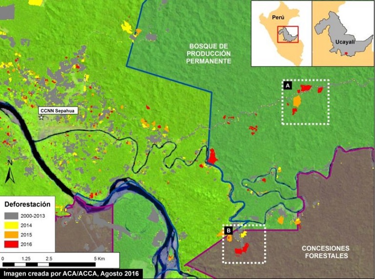
Invasions in the forests of Ucayali
The third case involves the deforestation of 136 hectares in the town of Sepahua, south of the Ucayali region. Areas cleared by agricultural expansion are within a Permanent Production Forest and Forestry Concession (BPP).
“Both areas, which can be seen in the satellite images, allow logging, but in a sustainable manner and with regulation – agricultural activity is not permitted, so it qualifies as illegal,” said lawyer Araujo. He notes that there is an oversight of the concessionaire (the agent responsible for the concession) and the state when it comes to the forest concession.
“In the case of the BPP, the Agency for the Supervision of Forest Resources and Wildlife (OSINFOR) must also participate in the control of the logging that is practiced, since it is an activity that is not allowed and it clears forest.”
Zambrano, who is president of the management committee of the Tambopata National Reserve in Madre de Dios, says that the government is not doing its part to protect natural areas.
“More and more impacts are being added to more areas that have been impacted by unsustainable activities,” said Zambrano. “We’re worried about that.”
He added that alternatives to combat illegal activities are being sought.
“Let’s hope the new government has another perspective because the past one did not contribute anything.”
In the meantime, groups like MAAP will be keeping an eye out for changes in Peru’s forest cover.
Matt Finer of MAAP explained that his team’s analysis helps illuminate deforestation that would go undetected if it wasn’t for this “useful system that combines the early GLAD alerts with high-resolution satellite imagery analysis as part of a near real-time deforestation monitoring system.”
This story was reported by Mongabay’s Latin America (Latam) team and was first published in Spanish on our Latam site on September 13, 2016.