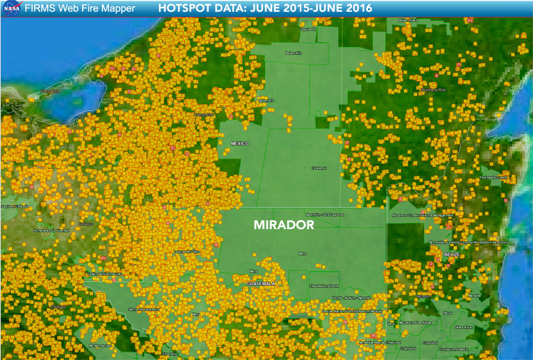
- Mirador-Rio Azul National Park is one of the best-conserved protected areas in Guatemala’s Maya Biosphere Reserve, where illegal logging and agriculture, forest fires, looting, and drug trafficking have contributed to deforestation.
- A plan to increase tourism to the area and redraw the boundaries of the park and adjacent community forest concessions aims to prevent these threats from compromising the area’s rainforest and important archaeological sites.
- Yet the plan has drawn widespread opposition from local communities, environmental NGOs, and the government agency charged with managing the reserve. Opponents say the plan would threaten the region’s ecology, local livelihoods, and community forest concessions that have successfully protected the rainforest.
| Other stories in Mongabay’s series on the Maya Biosphere Reserve: Killing of Guatemalan activist in the Maya Biosphere Reserve raises alarm Successes and many challenges in Guatemala’s Maya Biosphere Reserve Communities lead the way in rainforest conservation in Guatemala |
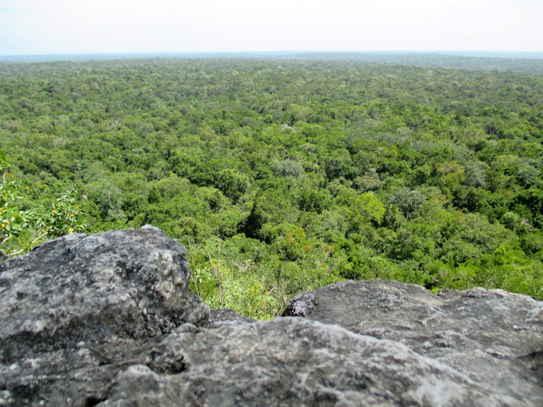
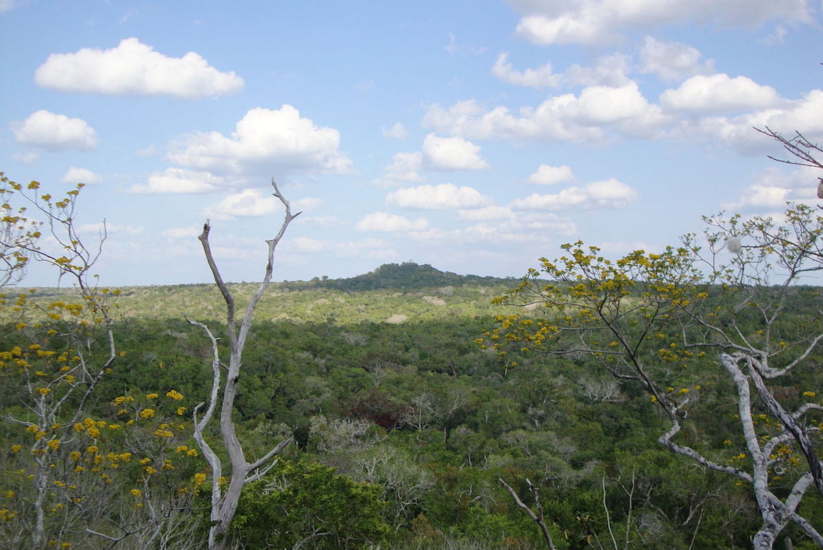
You hear them before you see them. It’s a frog-like croaking, coming from the treetops below as the sky begins to fill with light. The jungle goes on for as far as the eye can see from up here at the top of El Tigre, a temple in the ancient Mayan city of Mirador. It’s the momentary flash of movement and color in the canopy that gives the birds away. You can’t make out the bright orange, red, and lime green on their large beaks from here, but when they move their heads, it becomes possible to pick out the keel-billed toucans (Ramphastos sulfuratus) perched in the treetops.
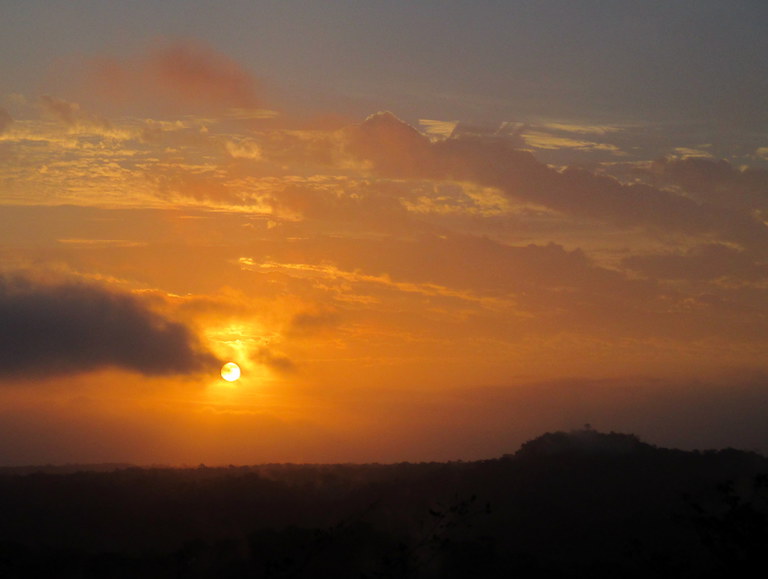
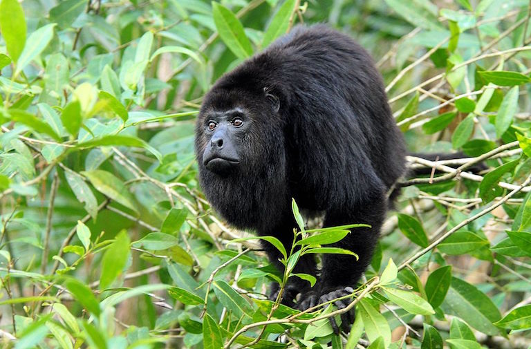
Pink clouds streak the sky as the sun starts to rise above La Danta. One of the two tallest pyramids in the western hemisphere and among the largest in volume in the world, it looms above the canopy. Down below, the calls of endangered Guatemalan black howler monkeys (Alouatta pigra) punctuate the birds’ dawn chorus here in Mirador-Rio Azul National Park, in the northern part of Guatemala’s Maya Biosphere Reserve.

It’s a 25-mile trek to get here from the closest village. There are no roads into the ancient city of Mirador or the national park, and nearly everyone wants to keep it that way. For some, that’s where the concurrence ends. Boundaries appear to be meaningless from on top of the pyramids, looking out across the seemingly endless tropical forest. There’s nothing to distinguish the international border with Mexico a few miles to the north. The boundary between the national park and neighboring forest concessions is also indiscernible from up here, but it has long been a subject of debate.
Conservation of the Mirador region, its rainforest, and the ruins of ancient cities scattered throughout the area has been mired in controversy for more than a decade. Archaeologists, local communities, government officials, environmental organizations, and private-sector corporations have a range of opinions and proposals on how best to move forward with conservation and tourism. At its core, the issue boils down to how the area is used, who controls it, and who benefits.
Cradle of a civilization
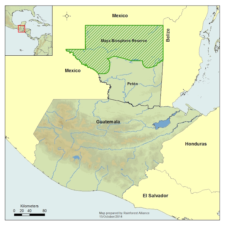
The Maya Biosphere Reserve was established in 1990. Larger than El Salvador, the reserve covers roughly the northern fifth of Guatemala. It is home to an estimated 180,000 people living in the southern buffer zone, the multi-use zone where controlled forestry activities are permitted, and, to a much lesser extent, the core zone comprised of nature reserves and national parks. The biosphere reserve is also home to jaguars (Panthera onca), scarlet macaws (Ara macao), and other iconic species.
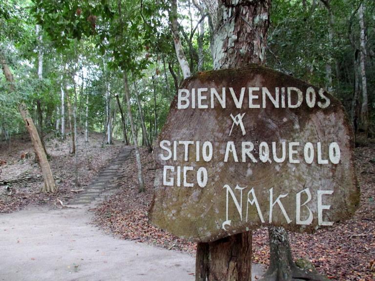
The area’s biodiversity and its concentration of the earliest Mayan cities go hand in hand, according to archaeologist Richard Hansen. An adjunct assistant professor at the University of Utah, Hansen has been studying Mirador and the dozens of other archaeological sites and ancient cities in the region for three decades.
“All the flora, the fauna, all of the biological aspects have played a role in the rise of complex societies in that region,” Hansen told Mongabay. Research dates the first human occupants to approximately 2600 BC, and by 1000 BC, there was permanent architecture, he said. Dozens of Kan (Snake) kingdom sites began to flourish in the area, many of them connected via massive causeways — raised roads built by the Mayans to traverse the lowland areas.
“It’s the cradle of Mayan civilization and we have the earliest cities there, the largest cities, the largest pyramids,” he said.


Hansen sees a need for change in how the area is managed, and he cites logging, agriculture, forest fires, looting, and drug trafficking as urgent threats to both the archaeological sites and the forest that he claims aren’t being addressed under the Maya Biosphere Reserve’s current management regime. As an antidote to that, as well as to the persistent poverty among reserve residents, he proposes developing tourism and pharmaceutical industry bioprospecting as part of an economic model to improve management of the ruins and forest.
Tourism based around the ruins — with eco-lodges set in the forest and a rail system to transport visitors between sites — could be developed to the point that it would finance increased conservation management of the area, according to Hansen. Under the rubric of a multi-faceted initiative called the Mirador Basin Project, which he directs, he proposes establishing a new protected area covering 837 square miles within the biosphere reserve. It would encompass the concentration of early Mayan sites that are now under the jurisdiction of Mirador-Rio Azul National Park and several multiple-use zone areas, including two community forest concessions.
Hansen’s current Mirador Basin Project proposal includes a designated roadless “wilderness area,” but over the past two decades, proposals have included a Mirador Basin National Monument, a Mirador Archaeological and Wildlife Preserve, and a new or expanded Mirador National Park. Regardless, any redrawing of the boundaries within the Maya Biosphere Reserve would entail legislative reform, as would the creation of a wilderness area, a category of protected area that does not currently exist under Guatemalan law.
The Mirador Basin Project encompasses Hansen’s archaeological work, scientific research, and the proposal for the wilderness area. Hansen is the principal driving force behind the idea, but he’s not alone. Backers of the new boundary and tourism development proposals have included the San Francisco-based NGO the Global Heritage Fund (see disclosure statement at end of story) and Pacunam, a Guatemalan corporate-based foundation.
“I’m passionate and I’m emphatic about the need for change,” said Hansen. The future of the Mirador region will be determined by the actions of the Guatemalan government that came to power this past January, he said. “If we leave the status quo as it is, we’re going to lose it.”
Hansen told Mongabay that the fate of the Mirador region is dependent on decisive action in the next four years, but his now-or-never perspective is not new. “This is the pivotal year,” he told Outside Magazine in an August 2003 article. “If I fail, the forest is gone and the sites will be destroyed.”
Community concessions at stake
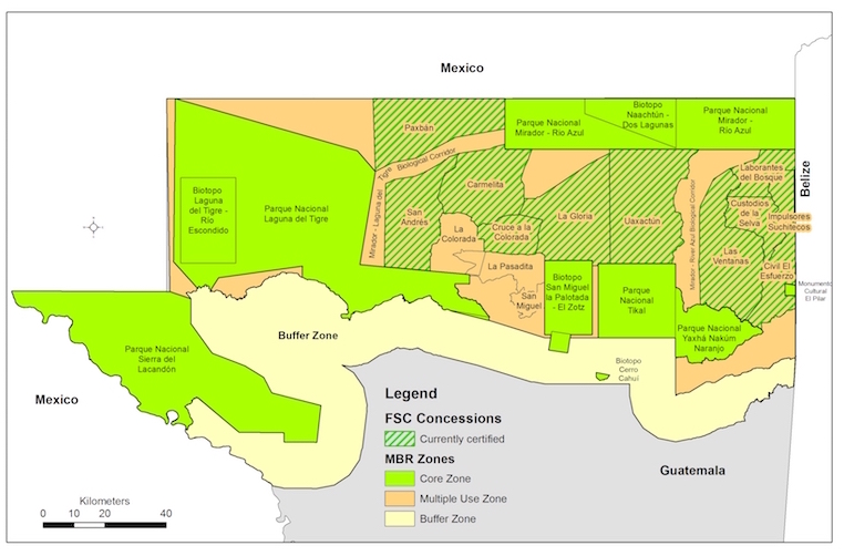
The main point of contention with regard to the proposed Mirador wilderness area is that it includes lands that belong to three forest concessions: La Gloria, Uaxactún, and Carmelita. There are eleven active forest concessions in the multi-use zone of the Maya Biosphere Reserve. La Gloria and one other are managed by companies, and nine by communities, including Uaxactún, and Carmelita. Communities harvest, process, and market wood and a variety of non-timber forest products, including ornamental xate (Chamaedorea elegans, C. ernesti-augusti, C. oblongata, and C. nerochlamys) palm fronds and ramón (Brosimum alicastrum) tree seeds.
Hansen’s view of the forest concessions, and of the NGOs that support them, is generally negative. Over the course of Mongabay’s interview with him, Hansen accused the village cooperatives managing community forest concessions of corruption, of involvement with drug trafficking, and of putting a price on his head back in the early 2000s. But he also credited the concessions with slowing down deforestation and said he fully supports the harvest of non-timber forest products like xate.
Hansen has never advocated disbanding the concessions, he said. His issue is with the logging they do, which he deems destructive and unsustainable.
“Unfortunately archaeologist Richard Hansen doesn’t see the work the forest concessions do in a positive light. And it has been demonstrated that the Mirador park is in fact conserved due to all of the forest concessions that exist around it,” Carmelita community tourism commission president Juan Carlos Marin told Mongabay. “If these concessions didn’t exist, this whole area would already be destroyed like the Laguna del Tigre and Sierra del Lacandon national parks.”
Marin’s point is echoed by the governmental National Council for Protected Areas (CONAP) and environmental NGOs. Along with the lack of roads, the forest concessions and other multi-use zone areas provide a wide buffer along the western and southern edges of the existing Mirador-Rio Azul National Park against key challenges afflicting the Maya Biosphere Reserve. These are the expansion of agriculture and cattle ranching, illegal logging, and fires. The park’s northern border with Mexico and eastern border with Belize are protected by contiguous extensions of forest.
Hansen agrees that the Mirador-Rio Azul National Park has been less impacted by the reserve’s key challenges, but he sees their advance as inevitable. “It’s just a matter of time, that’s all,” he said. Major change is needed now to stop that from happening, he said. “There’s a tremendous hope for that country if they just have the vision.”

Communities, NGOs and CONAP argue that there is a vision: it’s laid out clearly in the Maya Biosphere Reserve master plan and management plans, and the community concession model is an integral part of that vision. In fact, the deforestation rate in the multi-use zone that includes the forest concessions is near zero — lower than that of the core zone national parks.
Of the three concessions at stake, the Carmelita community forest concession would be most affected by the proposed new Mirador wilderness area. Residents of the concession’s 100-year-old village would be left in a dire situation, said Marin. “We would have to leave the area of Carmelita,” he said. He and other local leaders estimate they would lose roughly 40 percent of the concession, severely affecting everything from selective logging to community-run tourism.
The village of Carmelita is located inside the concession, and it’s the starting point for five- and six-day treks to visit Mirador and other ancient cities. A smattering of people with the means to do so travel directly to Mirador by helicopter, but access is primarily on foot. Somewhere in the neighborhood of 2,000 people hike in every year — less than 1 percent of the annual visitors to Tikal.
Along with forest management activities, the Carmelita cooperative includes a community tourism commission. Community-led tourism has been around for decades, but the commission was established in 2007. Community-led multi-day treks to Mirador involve guides, cooks, pack animals, mule drivers, supplies, and coordination. “We have a fairly large rotation system that includes men and women. We try to implement the rotation system as well as possible so that the benefits are distributed in a just way among all concession residents.” Marin said while seated at the desk in the cooperative’s new tourism agency installations in Flores, the central hub for trips to Tikal, Mirador, and other areas of the Maya Biosphere Reserve.
Carmelita residents are concerned that if mass tourism were developed, they’d be left out in the cold. Instead of managing their own treks and livelihoods, locals worry they could be relegated to low-end service industry employment with outside companies that would reap the profits, according to Marin.
However, Hansen maintains that the kind of tourism development he envisions would improve, not compete with local livelihoods in the concessions, by increasing job opportunities and incomes. As proof of its commitment to the local populace, he pointed to his project’s current employment of guards to defend archaeological sites from rampant looting, literacy training for workers, investment to date of $15 million in the region, and various donations, including a water purification system in Carmelita, and computers in area schools.

Mixed messages
Guatemalan president Jimmy Morales bypassed Carmelita when he traveled by helicopter to Mirador on February 20, less than 40 days after he took office. Morales made the trip with Costa Rican president Luis Guillermo Solís and was accompanied at the site by Hansen, among others. Several organizations working in the Maya Biosphere Reserve saw the trip as a potential indicator of early executive branch support for the Mirador Basin Project.
Six days later, however, a high-profile government delegation traveled to concessions in the biosphere reserve, and expressed strong support for the community forestry model. “That’s what I saw today… that the concessions work,” finance vice minister Lionel López said at the February 26 press conference.
A month later, the Guatemalan Tourism Institute (INGUAT) and Hansen held a press conference concerning the Mirador region. Plans for a 100-passenger train to Mirador and other ancient Mayan cities in the area were moving forward, INGUAT director Jorge Mario Chajón mentioned at the March 23 press conference. Contact with the private sector for the train and other tourism development at Mirador had already been made, he said.
The reaction in the Petén department was swift and overwhelmingly negative as communities, NGOs, and tour operators rejected the lack of local consultation. Major tourism infrastructure development in core and multi-use zone areas would also require environmental impact assessments and regulation by CONAP. There was also some opposition to the train itself, which would have almost undoubtedly traveled through Carmelita’s forest concession, which includes the La Florida and El Tintal archaeological sites. The community forest model has historically protected the area, and its recognition was part of the Maya Biosphere Reserve’s creation and of the fulfilment of the 1996 Peace Accords that ended 36 years of armed conflict, the Guatemalan National Alliance of Forest Community Organizations wrote in an April 1 statement.
The government was quick to backtrack following the outpouring of rejection. Instead, INGUAT would form an interinstitutional commission to analyze tourism development at Mirador and any project would have to be agreed upon by people in the region, Chajón announced at an April 5 press conference.,
This year isn’t the first time initial government support for Hansen’s Mirador plans has fizzled out. There was support from the administration (2000 – 2004) of Alfonso Portillo, who recently served a jail sentence in the US for taking bribes. There was also presidential-level support during the administration (2008 – 2012) of Álvaro Colom, whose far-reaching, multi-pronged Cuatro Balam plan for the Petén included elements of the Mirador Basin Project. Forest communities and environmental organizations campaigned against the plans, none of which materialized as originally envisioned.
Salvador López’s frustration was clear when he addressed the four-year cycle of Mirador plans, support, opposition, and rejection. López was still the CONAP regional director for the Petén when he spoke to Mongabay in his office in March, but was soon after replaced by the institution’s new executive secretary appointed by Morales. (The cascading turnover of personnel at the outset of each government administration is one of the problematic institutional issues affecting the Maya Biosphere Reserve.)
“At the beginning of every government, these kinds of people approach [the government] in order to sell ideas that entail their own benefit, not that of the communities,” López said. “It’s already been shown that it is not possible, that it is not accepted,” he said of the Mirador Basin Project proposal.
Despite the turnover within CONAP, the institution has consistently opposed the various iterations of Mirador plans that would affect other areas of the biosphere reserve, sometimes even despite presidential or congressional support. Both CONAP and the Guatemalan Institute of Anthropology and History (IDAEH) made formal submissions opposing a proposed law in 2010 that would have created a Mirador Basin protected area based on Hansen’s plan, contravening existing legislation.
“I think that a good message here is that we’re going to say enough already with people like Richard Hansen,” said López. “They push totally harebrained ideas, when there’s already a whole land-use plan there and a management plan, which should be followed,” he said. Instead of redrawing boundaries and cutting into forest concession lands, what’s needed is redoubled efforts to improve reserve management and combat threats, according to those who oppose Hansen’s proposals.
Enter the corporations
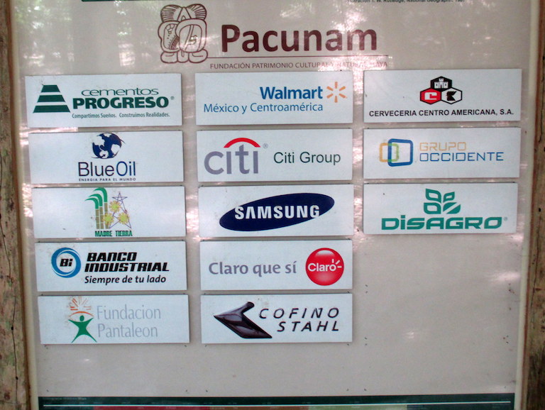
López’s mention of people pushing harebrained ideas wasn’t only in reference to Hansen but also to private-sector involvement in Mirador development plans. The decade-old Foundation for Maya Cultural and Natural Heritage (Pacunam) is comprised of a who’s who of the Guatemalan business world: powerful cement company Cementos Progreso, Walmart of Mexico and Central America, banks, agro-industry companies, and others.
Pacunam has financed Hansen’s archaeological work to the tune of millions of dollars over the years, and has actively promoted his tourism development plans. Foundation representatives also accompanied president Morales’s February visit to Mirador. Groups opposing the Mirador expansion plans often view Hansen and Pacunam as having a joint agenda, but according to Hansen, that’s not entirely the case. Pacunam has been an important supporter of conservation and archaeological work in the region, he said, but the foundation’s new plan for road access is cause for strong disagreement.
“Pacunam’s one of my sponsors. I formed Pacunam. I actually gave them their name. I gave them their logo. But I’ve created a monster,” Hansen said, referring specifically to the foundation’s road plans, should they materialize. “Their agenda is black. It’s not good.”
The foundation is proposing to connect Mirador and other Mayan sites in the Maya Biosphere Reserve by road in order to facilitate mass tourism, according to Hansen and NGOs working in the region. However, its plans have not been made public, and Pacunam did not respond to Mongabay’s request for comment.
The foundation’s interests and role in the Mirador dispute face widespread opposition. “Any matter of tourism development must benefit the communities. We’re not going to benefit any particular group of individuals or corporations,” said López. “If we’re going to put benefits to private sector companies in there, then that distorts the spirit of what forest concessions and sustainable management are.”
Along with making sure local communities retain a central role in any tourism development, the potential ecological impacts of increased tourism are another concern for CONAP, Carmelita, and NGOs alike. Mirador Basin protected area and tourism development plans have included estimates upward of 80,000 visitors per year within 10 years.
“We’re very leery of proposals that offer a big boom in development without really understanding how that’s going to affect nature and culture,” Wildlife Conservation Society Guatemala director Roan Balas McNab told Mongabay. “For the sake of future generations, our point of view has been to be cautious and to urge step-wise development of these treasures.”
Balas McNab suggests first figuring out how to manage 5,000 visitors per year to Mirador while mitigating ecological impacts, and then perhaps discuss how to manage 10,000. “But let’s not promise 100,000 people overnight at Mirador because it’s going to be too much to manage,” he said. “So our recommendation in terms of all of the proposals is let’s find a way to get the most out of the area for Guatemala, for nature and culture, and for local people especially, and make sure they have a leading role.”
At El Tintal, one of the principal archaeological sites inside the Carmelita community forest concession, local people are busy taking on all roles at the camp, unpacking animals, cooking, and setting up tourists’ bedding in tents. Trekkers spend the night here on their way to and from Mirador. From the top of the tallest pyramid structure in El Tintal, La Danta is visible about 15 miles away. The view overlooks the forest canopy stretching on for miles, rendering concession and park boundaries invisible. Parrots and swallows fly past as the sun goes down, a fiery red ball dropping down behind the seemingly endless jungle.
| Corrections 7/1/16: This story has been modified from its original version to 1) avoid potentially erroneously implying that Richard Hansen, director of the Mirador Basin Project, advocated disbanding community concessions within the Maya Biosphere Reserve; 2) provide additional context for the Mirador Basin Project’s present activities; 3) clarify the emphasis of a March 23 press conference held by Hansen and Guatemalan government officials; and 4) clarify Hansen’s comments about Pacunam. The changes were made in response to a note from Hansen. |
| Disclosure: This series on the Maya Biosphere Reserve is supported by a grant from the Morgan Family Foundation. Jeff Morgan, the foundation’s trustee, founded the Global Heritage Fund, which, along with the Morgan Family Foundation, has funded Richard Hansen’s Mirador Basin Project. Morgan is also the founder of Global Conservation, an NGO working to protect Mirador-Rio Azul National Park and to expand park boundaries and tourism development. Global Conservation identifies Hansen as a Global Conservation project director. Mongabay’s executive director Rhett Butler serves on Global Conservation’s advisory board. However, Mongabay editorial staff maintained full editorial control of the series. |