- The plan involves excavating and dredging a 275-km (171-mile) swath and constructing a canal with locks from the Atlantic Ocean across the Cerro Silva and Punta Gorda Nature Reserves, through Lake Nicaragua, and westward to the Pacific Ocean.
- Scientists and project proponents agree that the feasibility of the venture rests, in part, on water quality and quantity flowing into Lake Nicaragua and the future canal. Additionally, both acknowledge that seismic activity in the region could pose dangers to the integrity of the design’s infrastructure.
- HKND, the Hong Kong-based firm with the concession to develop the canal, has sought to quell concerns about the plan’s feasibility, but scientists remain skeptical.
Scientists have warned that a controversial proposal to construct an inter-oceanic canal through Nicaragua is founded on incomplete knowledge of its environmental feasibility. In fact, many social and ecological processes and current events will likely undermine the project’s success.
The plan involves excavating and dredging a 275-kilometer (171-mile) swath and constructing a canal with locks from the Atlantic Ocean across the Cerro Silva and Punta Gorda Nature Reserves, through Lake Nicaragua, and westward to the Pacific Ocean. Scientists and project proponents agree that the feasibility of the venture rests, in part, on water quality and quantity flowing into Lake Nicaragua and the future canal. Additionally, both acknowledge that seismic activity in the region could pose dangers to the integrity of the design’s infrastructure.
HKND, the Hong Kong-based firm with the concession to develop the canal, has sought to quell concerns about the plan’s feasibility, but scientists remain skeptical. Indeed, their suspicions seem to be well-founded, judging by current conditions and recent events. Drought, declining water levels, expanding deforestation, rising sedimentation, and frequent seismic events do not bode well for an undertaking that requires stable ecological and geological conditions.
Minimal water depth required for the canal to allow the transit of 400,000-ton ships through Lake Nicaragua, as envisioned by the developers of the proposal, is 30.2 meters (about 100 feet) above sea level. However, in a recent report by scientists at the Humbolt Center, the water levels of Lake Nicaragua during the first four months of 2016 dropped a full 1.12 meters below the lake’s historic average of 31.32 meters above sea. This represents a two percent drop in the lake level, and with a current level of 30.20 meters, it barely meets the minimum level required. Scientists cite large-scale climate change, El Niño effects of 2014 and 2016, and local effects of deforestation as factors behind higher evaporation and reduced precipitation.
Combined with increasing human demands on freshwater sources in the watershed, the chances that there will be enough water for the scheme may be drying up before the development even commences.

To thwart the risk of water shortages, the HKND Group anticipates storing vast volumes of freshwater for use in canal operations in a proposed reservoir, as well as mitigating the effects of deforestation. The group plans to create two reservoirs that will intercept and store water from the watersheds of the Cerro Silva and Punta Gorda Nature Reserves. However, massive incursions and deforestation by non-indigenous colonists in the region have left the watersheds vulnerable to drying and erosion. This situation could worsen if communities displaced from the reservoir areas add to the ranks of the other colonists.
Government officials have generally turned a blind eye to the worsening situation, and the Humboldt Center report argues that the current government administration follows exploitative policies that contribute to a socio-environmental crisis. This crisis highlights serious shortcomings in terms of governance of critical natural resources, including freshwater.
Whether the designed reservoirs will be able to fulfill their function, given the rapidly declining conditions of Nicaragua’s essential watersheds, is not clear. But what is eminently clear is that the likelihood that these trends can be reversed declines with each passing day that the government fails to take action.

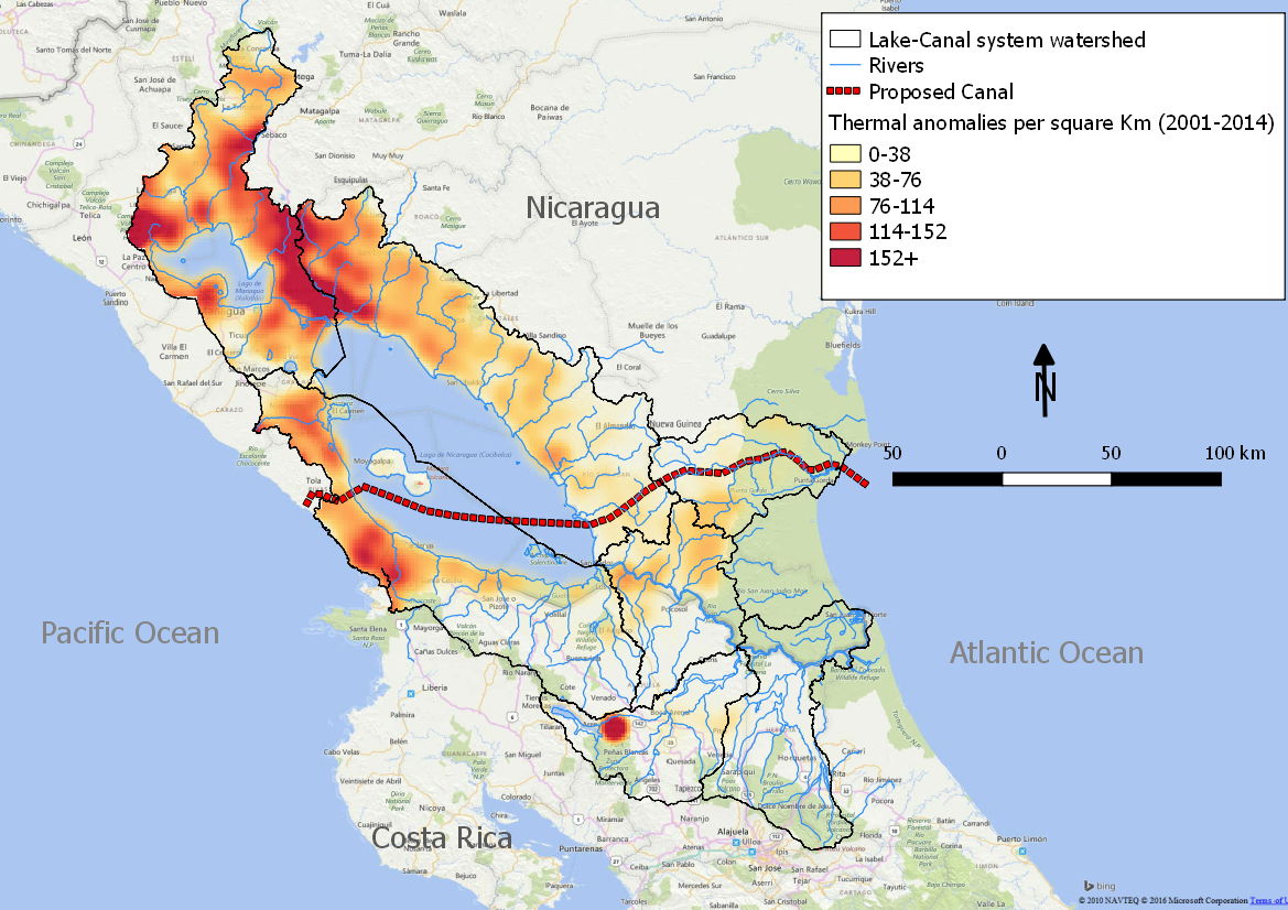
Deforestation and erosion impacts are not restricted to the eastern portion of Nicaragua; rather, numerous watersheds contribute freshwater and sediment to the lake, including watersheds that cross international boundaries.
Many of the sediments that flow into Lake Nicaragua arise from watersheds located on Costa Rican territory. Despite Costa Rica’s generally good record on environmental protection, enforcement of regulations that govern riparian areas is often lax, particularly in remote areas and along the northern border with Nicaragua. This leaves rivers and streams prone to accumulate agricultural runoff and sediments. Loss of riparian habitat, exacerbated by current forest fires, worsens the precarious riparian conditions.
It is probably unrealistic to expect the Costa Rican government to change its modus operandi for the purpose of aiding the Nicaraguan project, given a long history of border disputes and other disagreements.

If declining water quality and quantity do not convince investors of the feasibility issues for this $40-billion-dollar proposal, perhaps the recent explosion of a long-dormant volcano, or the many earthquakes over the past two decades, will underscore its inherent risks.
On December 1, 2015, residents of Leon, Nicaragua were surprised that the sleeping giant, Momotombo Volcano, awakened after a 110-year dormancy with a series of eruptions. Located a mere 78 kilometers (about 50 miles) north of Lake Nicaragua, it is not the only active volcano near the lake. Since Momotombo awakened, two others — even closer — have likewise been erupting (Masaya and Rincón de la Vieja of Costa Rica).
Although the HKND Group’s proposal preceded the recent volcanic activity, the firm’s plan to position the canal through the nation’s southwestern corner places it squarely in the Ring of Fire, well known for its seismic activity. Not surprisingly, the region is riddled with volcanoes and, over the past two decades, has experienced several dozen earthquakes registering magnitudes at or above 5.5 on the Richter scale.

Currently on hold, the canal scheme may not take shape as HKND now envisions, and, if history repeats itself, almost anything — or nothing — could take shape.
The HKND plan is one more incarnation of a recurring dream that dates back centuries. Each time, the dream is resurrected as a silver bullet to get rich – for instance, getting from the east coast of the United States to California during the Gold Rush. Now the Nicaraguan president claims that the silver bullet will jump-start the economy, perhaps a noble goal of lifting people out of poverty in the second poorest country of Central America. But just like the dreams of previous generations, this one may be full of holes.
Will the HKND Group and the Nicaraguan government heed the signs of a ship that will likely sink before christened?