- Draining peatland for tree plantations is considered one of the main drivers of Indonesia’s 2015 fire and haze crisis.
- Even if they aren’t burned, drained peatlands release huge quantities of CO2.
- New research and analysis finds oil palm and wood fiber plantations have continued to expand into peatlands in recent years, with consequential carbon emissions equating to more than 6,000 gallons of gasoline burned for every hectare of peatland drained.
As Indonesia attempts to head off another year of catastrophic fires and smoke that choked the archipelago and many other parts of Southeast Asia in 2015, attention is increasingly turning to peat forests. Fires on peatlands were the primary source of this devastating “haze,” with many observers pointing blame at human activities like plantation development that dried up normally waterlogged peat and made them ripe to burn. New research finds that plantation expansion into peatlands in parts of Indonesia and Malaysia has increased 37 percent in the past five years, with emissions from peat draining amounting to 55 tons of CO2 per hectare in 2014.
Tropical peat naturally exists in a swampy state that is resistant to fire. But when drained, peat becomes highly flammable and, when burned, emits far more carbon than non-peat forest. This is because peat is made up of dense, carbon-rich material from dead vegetation that has been accumulating for hundreds, even thousands, of years. Much of Indonesia’s peat deposits are at least two meters (6.5 feet) deep, providing a huge supply of fuel for wildfires. And once a dried peatland starts burning, it is hard (read: impossible) to stop it through conventional firefighting methods.
Industrial agriculture operations like oil palm and wood fiber tree plantations have been increasingly targeting peat forests in Indonesia and Malaysia as they run out of other places to expand. But peatlands are naturally too wet for tree plantations, and so companies dig long canals to drain the soil and make it more suitable for development. And as more peat is drained, the fire risk is heightened. Propelled by a hot and dry El Nino, as well as slash-and-burn land clearing, this risk was upped to its breaking point last year. Subsequent fires ravaged around two million hectares of Indonesia – an area the size of Israel – from June through October, releasing dangerous amounts of smoke that affected an estimated 28 million people in Indonesia alone. Nearly half a million people were reportedly diagnosed with respiratory illnesses due to the haze. At the peak of the crisis, the daily carbon emissions from these fires topped even U.S. emissions, making Indonesia one of the world’s biggest carbon polluters of 2015.


The last few years have been big in terms of plantation expansion into peatlands. A study published this month in the journal Global Ecology and Conservation calculated that the amount of industrial oil palm and wood fiber plantations situated on peatlands in Borneo, Sumatra, and neighboring peninsular Malaysia rose from 3.1 million in 2010 hectares to 4.3 million hectares in 2015 – a jump of 37 percent in five years. In total, it found more than two-thirds of the peatlands in those areas have been degraded, with just around 29 percent still forested.
Degraded peatlands don’t just emit carbon when they burn. Just the act of draining them is enough to release substantial CO2 loads, as removal of water in peat opens it up to microbes that break down its organic matter and discharge into huge quantities of carbon into the atmosphere.
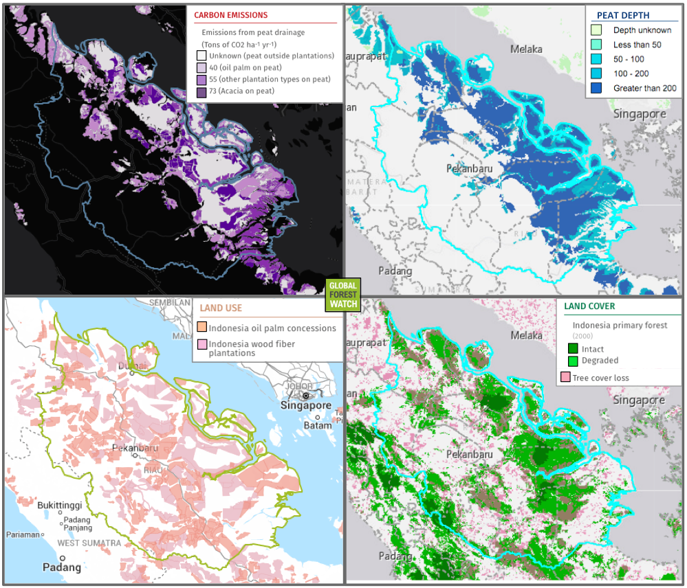
Analysts at the World Resources Institute (WRI) compiled emissions data on converted peatlands within tree concessions in Indonesia and Malaysia, finding that 55 tons of CO2 is released for every hectare of drained tropical peatland on average in 2014. In other words, they write in a blog post, draining one hectare of tropical peatland produces more greenhouse gas than burning 6,000 gallons of gasoline.
The team’s analysis is visualized on the monitoring platform Global Forest Watch Climate. It shows how much CO2 was released by degraded peatlands per concession type in 2014, ranging from 40 tons per hectare for oil plantations to 73 tons per hectare for acacia wood fiber plantations.


In response to the 2015 haze crisis, the Indonesian government has been tightening management of its peatlands, establishing a peatland restoration agency and vowing to restore two million hectares of peatland by 2019. The agency is also looking at developing an early warning system that would potentially assess the risk of fire in peatlands by keeping an eye on their temperatures and moisture levels. Earlier this month, Indonesia’s president Joko Widodo announced plans to enact a moratorium on new palm oil and mining permits in effort to protect his country’s remaining forests and peatlands.
Disclaimer: Mongabay has a funding partnership with the World Resources Institute (WRI). However, WRI has no editorial input in regard to content.
Citation:
- Miettinen, J., Shi, C., & Liew, S. C. (2016). Land cover distribution in the peatlands of Peninsular Malaysia, Sumatra and Borneo in 2015 with changes since 1990. Global Ecology and Conservation, 6, 67-78.


