
- The Kogi people have a unique spiritual and ecological connection with the forests they live in, but the forest is now under threat from gold mining, agriculture, and human development.
- The Amazon Conservation Team is piloting an open-source phone app (ODK) to help the Kogi gather data and create geo-referenced maps of their land
- ACT and the Kogi plan to use the detailed digital maps to protect sacred and ecologically important sites from deforestation, and reclaim traditional land holdings.
Deep in the Sierra Nevada de Santa Marta mountains, with peaks that soar over 18,000 feet over the Colombian coast, the Kogi people live on roughly six million isolated from the rest of the world by cocaine traffickers, tomb raiders, and militias that rove the rainforest. The Kogi and associated tribes are one of the last surviving civilizations from the pre-Colombian period, having fled the Spanish conquest five centuries ago. The Kogi, Arhuaco, and Wiwa remain true to their ancient laws—moral, ecological, and spiritual—and are still led and inspired by priests, or mamas, who have an exceptional spiritual connection with the ecosystems in which they live.

Around the margins of the Sierra Nevada is the Línea Negra – the “Black Line” – a chain of 54 pilgrimage sites sacred to the Kogi and once part of their ancestral territories. Most of the sites are no longer under Kogi ownership or control and have come under threat by poorly-planned development schemes and illicit crop cultivation. Many of these sites are vital water sources and encompass lagoons, springs, and wetlands. Other sacred sites include ancient paths, terraces, and cities from the Tayrona culture, the ancestors of the indigenous peoples of the Sierra.
With these sites under threat, the Amazon Conservation Team (ACT) has announced a new pilot to help the Kogi map their lands using an open-source mobile software called Open Data Kit. In an email interview with WildTech, Brian Hettler, the GIS and New Technologies Manager, explained the Kogi’s relationship with nature, and the new pilot underway in Colombia.

The Kogi believe that the sacred sites are interwoven by a complex network of spiritual connections. “At first I thought these connections were loosely related to natural systems, like drainage basins”, says Hettler. “I learned that these connections are more intangible, and two sites on opposite sides of the Sierra can be connected”. Many of the indigenous sacred sites are also of high ecological value, providing important wildlife habitat and breeding grounds.
A BBC documentary in 1990 documented the Kogi’s unique connection with nature and natural processes. In it, they talked about landslides, floods, and drought they were witnessing, a result of the industrialization and deforestation happening across South America but something the Kogi themselves didn’t know about.
As the Kogi continued to face problems to protect the sacred sites, they contacted the ACT, who established a project in 2012 to help the tribe document each site’s ecological and cultural information to prioritize site recovery within a longer-term territorial reclamation process.
Even with help from ACT, a major problem still confronted the group: how could they collect accurate, standardized, geo-referenced data to produce the maps needed for the process?
This challenge is not uncommon. Traditional methods for participatory mapping have involved a multi-step process, using community-wide discussions and pen-and-paper mapping sessions, during which the indigenous people draw the locations of important resources and sites directly onto paper maps. However, claims for land rights require precise data not possible from simple paper maps, so the community discussions are followed by the physical mapping of important areas and boundaries by training village members in the use of GPS equipment, a time-consuming process made more challenging by the remote location of the Kogi and the language barriers.
The challenge, then, remains how to harness indigenous people’s intricate knowledge of their land in a way that can easily turn these rough internal maps into digital and physical representations that can be compared accurately with things like proposed concession areas, research sites, or other activities.
Mapping sacred sites
To map the Kogi’s sacred sites, Open Data Kit quickly became the first choice for ACT. “Mobile devices are becoming more and more common in these villages every year, and this technology is connecting communities to the outside world like never before,” says Hettler. “ACT’s custom [ODK] apps allow this technology to be harnessed for good to monitor and protect natural resources and to record cultural land use patterns.”
To build the survey, ACT drew from another major data collection initiative in Suriname that equipped indigenous park guards (IPGs) with ODK mobile software to monitor wildlife, natural resources, and environmental threats around the villages in southern Suriname. “It’s open-source software,” explains Hettler, “[which makes] it more accessible and flexible than some other existing data collection apps.”
Wildtech first covered ODK in February of this year. Check out the article to learn more about how ODK works.
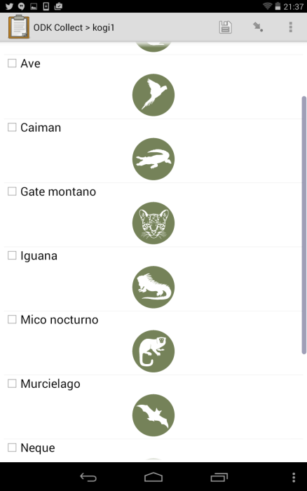
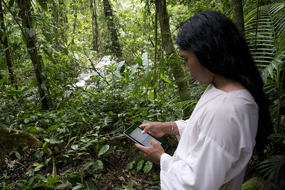
ACT is now piloting a customized ODK application with the Kogi, which uses translated language and symbols to help the data collectors fill out each survey. The app allows them to map and inventory their complex network of sacred sites and trails and generate records on ancestral roads, archaeological sites, and petroglyphs.
“They can seamlessly record geographic coordinates and photographs of these features, and younger members of the Kogi survey team are able to interview and record their elders describing oral histories regarding the importance of the sites to pass on to future generations.”
The app also has fields for recording ecological and biodiversity data, which can provide additional incentives to protect the land. A third section of the app allows the Kogi to record the external pressures that threaten their sacred sites, information that they can then bring to local governments and use to help raise awareness on development projects that threaten their rights.
“The app is operable on any Android smartphone or tablet device equipped with a GPS unit, meaning that we no longer must purchase dedicated devices for data collection; community members with an Android phone can start collecting data right away,” Dr. Mireya Mayor, a National Geographic Explorer and correspondent for ACT, told WildTech.
Mobile tools simplify data collection among indigenous groups
ACT paints the transition to ODK for the Kogi project as an easy decision, mainly due to number of online resources for the software, like XLSform, which includes all of the necessary information to build a wide variety of ODK applications. “Overall, the transition to ODK has streamlined the data collection process by removing the need to spend hours consolidating GPS data, photographs, and hand-written field notes. [That] outweighs the learning curve for ACT staff to design and deploy ODK apps.”
Hettler also credits the training and support from Google Earth Outreach for the smooth transition. “At Google’s annual Geo for Good User Summit, ACT’s mapping team learned how to design more complex, layered ODK apps, and how to set up ODK Aggregate, the data aggregation system used to consolidate field data.” To secure devices for the project, ACT also partnered with Benetech, a fellow Skoll Foundation Awardee, to provided hardware for ACT to launch its first ODK projects.
Google appears to be leading the way on indigenous and participatory mapping projects using the open-source Google Earth Engine, with projects in Brazil, Canada, and other countries around the world. They have even gone so far as to embed these maps into Google Earth for others to explore. In an interview with Mashable, Chief Almir of the Suri people in the Brazilian Amazon shared his thoughts on technologies place in documenting culture. “Culture’s not something that’s static, it’s something that evolves, but we also recognize the value of our history and our culture and protect that,” he says. “It’s important to use technology to record the evolution of our culture because the world has to know who we are and where we want to go.”
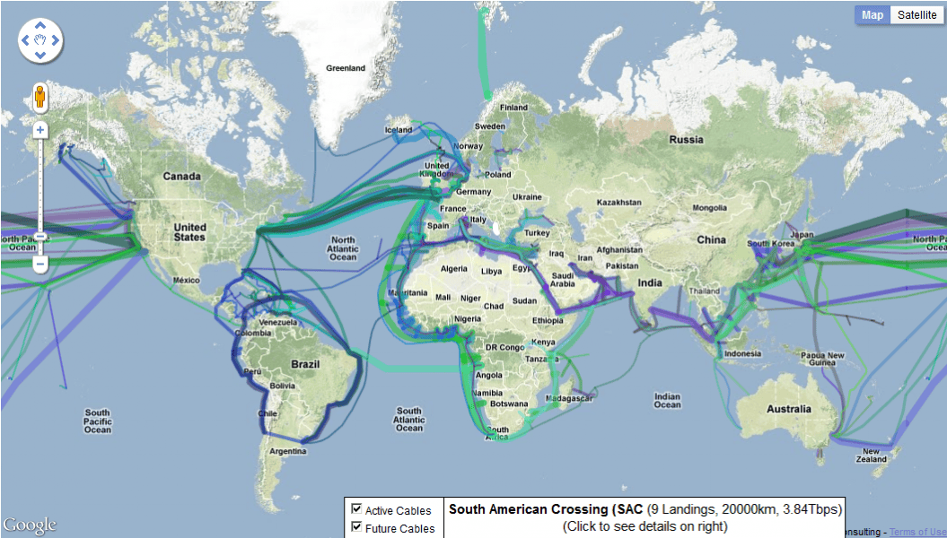
As for the Kogi, ACT was able to train them in the new technology and start collecting data quickly. Brain explained that the Kogi and nearby Trio and Wayana indigenous partners have responded “very favorably to the new technology, in large part because ODK is easier and more intuitive to use than a typical handheld GPS unit, which ACT has been using with these communities for many years.” Throughout the process, the Kogi have been extremely curious about the technology behind ODK, especially how data is transmitted to and from the cloud. “During some of the early workshops, we often deviated from the planned topics of conversation to answer their questions, for example explaining things like how satellites function,” Hettler explained. “One of the things that most surprised the Kogi was a map of worldwide submarine cables.”
While ACT expects to see challenges that occur when deploying new technologies in the field, such as battery charging, troubleshooting and connectivity, they are confident that the best practices from the Suriname project will transfer to the new pilot.
As governments and NGOs increasingly focus on protecting indigenous land rights, tools like ODK will become more essential to help local tribes map their land and share this data in a 21st century setting. These tools can also help researchers understand ecosystems through the eyes of indigenous people, who have untapped historical knowledge of their lands and a unique understanding of the natural features and processes.
For now, the ACT team remains focused on turning the troves of data from the Kogi poeple into maps that can help save their sacred sites. “We have had a lot of success with the project, and are excited to keep collaborating with the indigenous people in these regions to help them protect their ancestral lands,” says Mayor. “We see the data collection as a long-term project that will be ongoing for the foreseeable future.”

To learn more about The Amazon Conservation Team and their work with the Kogi and other indigenous tribes in the Amazon, please visit amazonteam.org. If you have used ODK for similar work, tell us about it in the Comment section below.