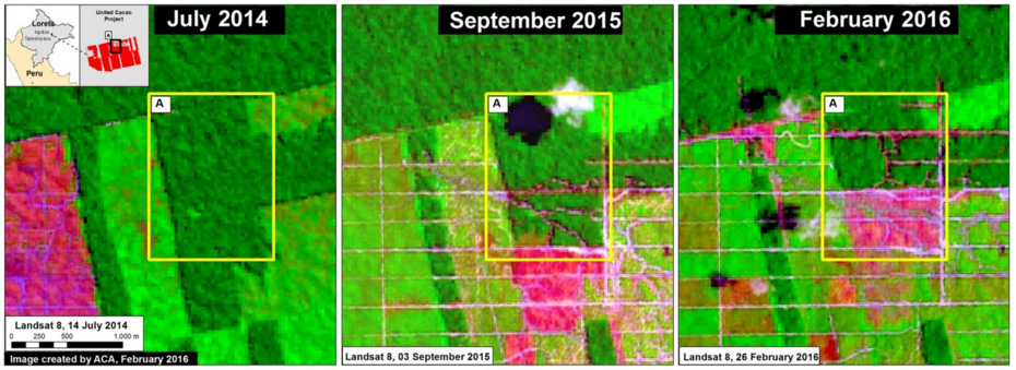
- Nearly 2,400 hectares have been cleared since plantation development began in 2013.
- Researchers say much of this deforestation is taking place in primary forest.
- The Peruvian government ordered United Cacao to stop development in 2014 due to environmental concerns.
Tucked away in northeastern Peru, a huge cacao plantation has been taking shape over the past few years. Touted by industry as a source for “sustainable” chocolate, critics say it has displaced thousands of hectares of primary rainforest and data show that it is continuing to grow- despite government orders to cease its development.
The plantation is located about 20 miles (32 kilometers) up the Amazon River from Iquitos, the largest city of Department of Loreto. Owned and operated by United Cacao (UC), development of the plantation began in 2013 and analysis of satellite imagery indicates around 2,400 hectares of forest have been cleared so far.
While UC representatives assert that the plantation is being developed on land that had been previously used for agricultural purposes, surveys by research institutions – like Stanford University’s Carnegie Airborne Observatory – strongly indicate that the area was covered in dense, undisturbed rainforest before UC started development.
In December 2014, the Peruvian government ordered UC to stop developing their cacao plantation – along with two UC-affiliated palm oil projects in southern Peru – citing environmental damage to the surrounding land and water sources, and the release of significant amounts of greenhouse gases caused by deforestation. The cease orders stated that UC lacked the authorization to deforest the region, and had not done the proper environmental studies prior to starting development.
However, this has not seemed to dissuade UC from their plantation plans. Since the 2014 injunction, researchers with the Monitoring of the Andean Amazon Project (MAAP) have detected 250 hectares of deforestation within the plantation area, and satellite images reveal big swaths of forest have disappeared.
Data published in Environmental Letters earlier this year and visualized through Global Forest Watch indicate a spate of deforestation occurred from late August to early November. Much of this clearing took place in an Intact Forest Landscape, which is an area of primary forest that’s particularly undisturbed, continuous, and biodiverse.
This latest round of data also show the construction of new roads along the plantation’s northern boundary, which MAAP researchers say may herald more deforestation yet to come.


Citations:
- Finer M, Novoa S (2016) United Cacao Continues Deforestation of Primary Forest in Tamshiyacu (Loreto, Peru). MAAP: #27.
- Hansen, M.C., A. Krylov, A. Tyukavina, P.V. Potapov, S. Turubanova, B. Zutta, S. Ifo, B. Margono, F. Stolle, and R. Moore. 2016. Humid tropical forest disturbance alerts using Landsat data. Environmental Research Letters, 11 (3). Accessed through Global Forest Watch on 3/16/2016. www.globalforestwatch.org