
- The Megaflyover is focusing on the five largest forest blocks still standing in Mexico and Central America.
- According to NASA’s Earth Observatory, the single biggest direct cause of tropical deforestation is conversion to cropland and pasture, “mostly for subsistence, which is growing crops or raising livestock to meet daily needs.”
- The flyover researchers are sharing the findings with national protected areas agencies in the region as they go, and overtime, they will analyze how human influence has expanded over this region over the past 15 years.
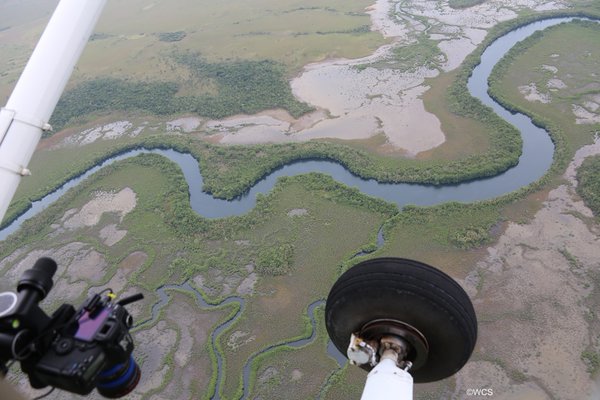
If you were to fly over Central America on a small plane, from north to south, starting in Guatemala and ending in Panama, you’d be able to see isolated yet extensive pockets of green canopy covering the territory.
This is exactly what the aptly named “Central American Megaflyover” has been able to document during its 3,100-mile flight that took off on February 26th and is set to end by the middle of March. An additional 1,900 miles will be traveled overland.
The crew includes researchers with the Wildlife Conservation Society (WCS) in collaboration with the U.S. Fish & Wildlife Service, a government agency with a history of conservation outside of America’s borders. The U.S. Fish and Wildlife Service has been working for years with a variety of partners and communities in Guatemala’s Maya Forest in Guatemala to help conserve the forest.
The Megaflyover is focusing on the five largest forest blocks still standing in Mexico and Central America: the Maya Forest that straddles Mexico, Guatemala, and Belize, Honduras and Nicaragua’s Moskitia, Indio Maiz-Tortuguero National Park in Nicaragua and Costa Rica, La Amistad International Park in Costa Rica and Panama, and Panama’s Darién Gap. All of these forested areas share a wide variety of plant and animal species, and are home to numerous indigenous groups.
The goal of the expedition has been to witness and study the impact of humans, and in particular, their livestock. The findings will help inform conservation initiatives in the region.
Dr. Jeremy Radachowsky, Director for WCS’s Mesoamerica and Western Caribbean Program, says that the team expected to find the usual and already-documented impacts of cattle ranching in all countries. But so far, the researchers have also come across new developments, especially in Honduras’ Río Plátano Biosphere Reserve on the Caribbean coast.
“Very surprising was the percent of deforestation in Río Plátano for cattle ranching,” says Radachowsky. “I would estimate that more than 95% of clearing is for cattle, and just tiny household plots for family gardens. Also surprising is the extremely low number of cattle in the cleared pastures. Cattle are clearly being used as an excuse for land grabbing.”
The reserve is part of the Mesoamerican Biological Corridor that stretches from Mexico to the southern tip of Central America, following the path of the Megaflyover itself. Río Plátano is home to a number of endangered species such as the Mantled howler monkey (Alouatta palliata), the Great Green Macaw (Ara ambiguus), and the Loggerhead sea turtle (Caretta caretta); in 2011 UNESCO placed the Río Plátano Biosphere Reserve on the List of World Heritage Sites in Danger.
According to NASA’s Earth Observatory, the single biggest direct cause of tropical deforestation is conversion to cropland and pasture, “mostly for subsistence, which is growing crops or raising livestock to meet daily needs.”
The WCS findings so far agree: cattle ranching is the primary driver of deforestation across the entire region, especially within protected areas. Then follows deforestation caused by oil palm plantations, usually just outside or at the edge of the protected areas.
Radachowsky explains how these factors typically work on the ground: Since the price of beef is almost $5 a pound in much of Central America, cattle production in protected areas is “typically not for consumption by local people or an important part of food security, but rather a business proposition by wealthy individuals.”
“In many cases, cattle ranching in protected areas is really driven by land speculation or for money laundering, with hopes of eventually obtaining title to the already degraded lands,” explains Radachowsky. “Much of the cattle produced in Central America’s protected areas ends up as contraband, with cattle from Belize, Guatemala, Honduras, and El Salvador shipped to Mexico.”
Deforestation caused by cattle ranching is especially rampant in Guatemala, Honduras, Nicaragua, and parts of Panama, he adds.
The Central American Megaflyover team members are taking detailed, high-resolution images they will compare with previous satellite imagery that was analyzed by WCS in 2002 to measure the extent of human influence across the earth’s land surface. The flyover researchers are sharing the findings with national protected areas agencies in the region as they go, and overtime, they will analyze how human influence has expanded over this region over the past 15 years.
“Anecdotally and through our own experiences, we have observed the widespread impact of cattle ranching on Central America’s forests,” says Radachowsky. “Now we will be able to unequivocally and scientifically demonstrate these patterns to the world.”