
- A cost-effective technology warns conservationists and wind farm operators via text message when a tagged bird flies past a virtual fence toward a turbine so that they can slow or shut down the machine to minimize fatalities.
- As wind farms proliferate, this system answers an urgent need to reduce fatalities among threatened or endangered large bird species from strikes against turbines, though further research is needed on the effectiveness of both the system and slowing or stopping turbines.
- Future iterations could include quicker alerts, weight reductions for deploying on smaller species, automated turbine shutdown, automated deterrents, and customizations based on species and field settings.
As wind turbines swiftly materialize across hills, mountain gaps, plains, coasts, and oceans in the optimistic quest for alternative energy and a less carbon-intensive future, over 500,000 birds are killed annually in crashes against these structures. An expanding market of technologies, such as radar, offers wind farms avifaunal warning systems to prevent such disasters.

A recent study based on California condor flight indicates that a new autonomous GPS geofence alert system integrating solar-powered biotelemetric tags can reduce avian collisions with wind turbines.
The technology consists of a small tag fastened to the bird, incorporating a GPS receiver and GSM communications to transmit high-resolution near-real-time location data and automated SMS alerts via cellular networks. This cost-effective, flexible and accurate system promptly warns conservationists and wind farm operators via text message when a tagged bird flies past a virtual fence toward a turbine so that they can slow or shut down the machine to curb fatalities.
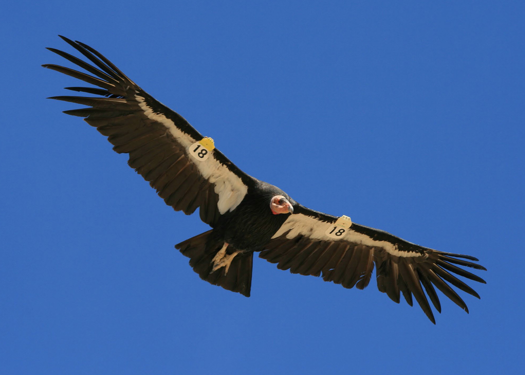
The system answers an urgent need for technologies that can reduce avian encounters with wind power infrastructure along movement and migration routes. As civilization moves toward clean renewable energy to limit greenhouse gas emissions, wind farms increasingly proliferate, raising the grave risk of birds fatally striking the moving turbines. The geofence technology could decrease such mortality and help conserve threatened or endangered large bird species whose ranges overlap wind sites.
This technological application is a big step for minimizing renewable energy impact on birds,” said co-developer James Sheppard, Postdoctoral Research Fellow at San Diego Zoo Global. “It’s a neat way emerging technologies can be applied for real-world tangible conservation benefits for species of concern.”
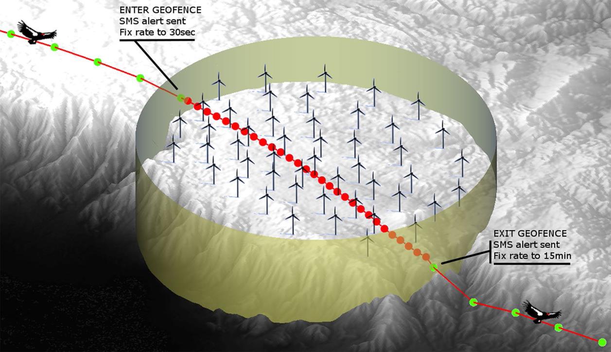
When a tagged bird crosses into the circle enclosed by the fence, the GPS location fix rate decreases from 15 minutes to 30 seconds, and an SMS alert reaches user groups within two minutes. When the bird exits this zone, they receive another alert, and the fix rate drops back to 15 minutes to save transmitter energy and data acquisition costs. To allow enough time for management action, the size of the virtual fence can be customized based on avian flight path and velocity, desired warning speed, mitigation response times, and technological conditions.
Sheppard maintains that the geofence system surpasses radar-based alternatives in various respects. Radar extends only a few kilometers from the wind farm and can be blocked by the typically hilly topography of the wind site, whereas the geofence has infinite range. Unlike radar, the new technology tracks birds individually and reveals the location and species of incoming avifauna. Most importantly, he added, radar costs up to $500,000 per installation, whereas geofence tags cost much less-$2,500 plus an annual $300 for data acquisition per device.
After studying three-dimensional condor movements, Sheppard and his colleagues have successfully implemented the geofence system in northern Baja California, Mexico. The area faces increased collision risk due to intensifying wind development intersecting with the expanding ranges of recently reintroduced condors. The technology assists local movements and dispersal by helping birds safely navigate wind farms in the region.
“We’re excited about the performance of the technology,” the ecologist said. “We’re very keen to expand it so that more birds have telemeters.”
Sheppard added that utility companies have responded well to the geofence technology. “The reception has been overwhelmingly positive. They want to play ball, to do the right thing. The technology offers a very cost-effective way to do that,” he said. “No wind farm company wants the PR disaster nightmare of being the first to kill a California condor.”
Companies he has met with claim they would suspend operations until any approaching bird left the geofence zone, despite the economic implications. If a bird loitered, conservationists could chase the bird out.
Virtual fences, which are gaining popularity as tools for a variety of wildlife conservation efforts, have several features that may help reduce human-wildlife conflict. They require no construction, maintenance, or removal and can be easily adapted over time and space to changing conservation needs. Geofences inform managers when tagged animals cross their paths and thus may help to integrate monitoring, research, and swift management action in response to the real-time data. They could potentially facilitate viewing opportunities while simultaneously protecting rare animals from a harmful situation. Bypassing the visual and emotional issues linked to traditional fences, virtual ones may also enhance support for conservation.
Using GPS with real-time geofencing for adaptive turbine regulation is a breakthrough; previous GPS projects only involved infrastructure placement based on impact models or retrospective studies of bird movement, perch sites, and roosts. Jachowski et al. (2013) proposed the possibility of harnessing real-time satellite tracking to inform turbine managers about incoming condors so managers could slow or shut down blades to reduce collision risk to the rare species. Noting the effective implementation of geofence collars in conserving American wolves and African elephants encroaching upon human territory, Sheppard applied the system to California condors.
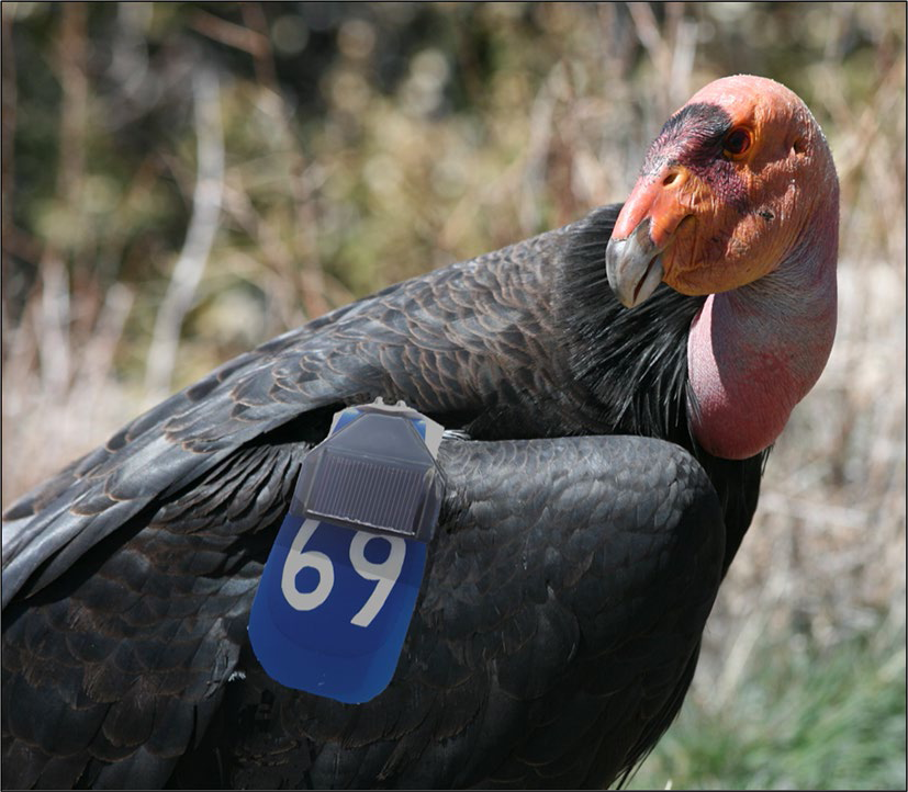
“Nobody had been able to shrink the technology to where it could be deployed on a bird. That was a big challenge,” he said. “Teaming up with Cellular Tracking Technologies, we were the first to miniaturize the technology to where it could be deployed on California condors, golden eagles, or cranes.”
Although the technology is promising, researchers note that it has several limitations. Because it must be fairly large to power itself, the biometric device is too heavy to attach to and track small birds. Since it is solar-powered, it can function only during daytime without extended severe weather. Another downside is the arduous process of catching and fitting birds with tags and recapturing to replace tags. In addition, poor GSM coverage in isolated areas where birds run into turbines could weaken system effectiveness; however, wind farm construction often comes with an expansion of the network.
As Marques et al. (2014) put it, collision risk depends on a complex nexus of multiple factors. These encompass characteristics of the species (morphology, sensorial perception, behavior and abundance), site (landscape, flight path, food availability and weather) and wind farm (turbine type and configuration, and lighting). Therefore, the mitigation technique offered by the geofence system is no panacea and must be tested across variables. This cutting-edge technology must be deployed using many species and field settings to better gauge performance and potential; it might be most effective when tailored to these differences and combined with other adaptive solutions.
Further research must also be conducted to determine the effectiveness of slowing or stopping turbines. Existing literature suggests these strategies work; griffon vulture mortality in the migration route from the Strait of Gibraltar to Africa fell by over 50 percent when operators selectively turned off turbines where the highest number of fatalities occurred (de Lucas et al. 2012). Even so, there is no guarantee that wind farm operators would consistently and adequately respond to bird alerts-which in themselves are not management actions-by modifying or halting turbine function. Managers could overlook or ignore warnings or deem collision risk insignificant.
Furthermore, data acquisition and handling constraints detract from real-time virtual fence technology. The satellite-based tracking system requires paying for data acquisition from telemetry companies; however, the cost is less for cellular phone systems or systems where managers regulate location fix rate, such as the geofence system. Geofence technology also requires the use of a telemetry company or a computer with Geographic Information Systems to create reliable data analysis tools to relate each animal’s spatial locations to the predefined virtual boundaries (Jachowksi et al. 2013).
Sheppard’s team envisions future iterations of the geofence system that include 24-hour operation, weight reductions for deployment on smaller species, and a regular fix rate below 15 minutes to quicken the first alert’s transmission. Other enhancements they hope for could integrate automated turbine shutdown, automated deterrents consisting of light and sound arrangements, or behavioral aversion mechanisms, such as buzzers that give birds an unpleasant but harmless stimulus via transmitter.
“We would like to have this technology be leveraged so that more wind farms incorporate the system to prevent collision injuries. We’ve presented a technological solution that’s very effective, that we would like to see as a mandated solution,” concluded Sheppard. “We’re all for clean green renewable energy, but not if it comes at a major cost to species we’re trying to protect and recover. Implementing a technological solution is a win-win for conservation managers, biologists and wind farms.”
Citations
De Lucas M, Janss GF, Whitfield DP, Ferrer M. Collision fatality of raptors in wind farms does not depend on raptor abundance. J Appl Ecol. 2008;45:1695–703.
Jachowski D, Slotow R, Millspaugh J. Good virtual fences make good neighbors: opportunities for conservation. Anim Conserv. 2014;17:187–96.
Marques AT, Batalha H, Rodrigues S, Costa H, Pereira MJR, Fonseca C, Mascarenhas M, Bernardino J. Understanding bird collisions at wind farms: an updated review on the causes and possible mitigation strategies. Biol Conserv. 2014;179:40–52.
Sheppard JK, McGann A, Lanzone M, Swaisgood RR: An autonomous GPS geofence alert system to curtail avian fatalities at wind farms. Anim Biotelem 2015, 3:45.
And some other ideas for reducing bird deaths from wind farms!