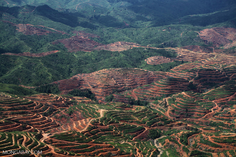
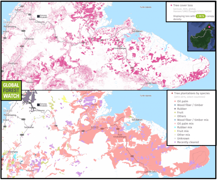
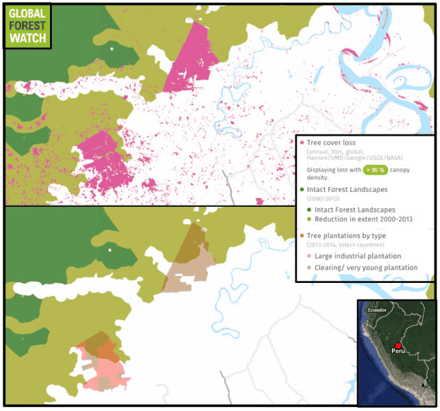
- An international research team mapped tree plantations in seven tropical countries that are currently experiencing plantation expansion.
- They found that those countries contained 45 million hectares of plantations – an area bigger than the U.S. state of California. While the more plantation-heavy countries were losing much of their tree cover inside plantations, several were losing upwards of 90 percent outside of them in areas of natural forest.
- The authors hope their study can help in land-use planning that directs plantation development and expansion to already-degraded areas rather than supplanting forests.
Nearly all of the recent tree cover loss in several “frontiers of plantation expansion” is happening outside established plantation boundaries, according to a study released Monday by the World Resources Institute. The study finds 90 percent of that loss is coming at the expense of natural forests in Brazil, Colombia, Peru, and Liberia.
Critically important to meeting the global demand for products such as timber, rubber and palm oil, tree plantations have begun to replace natural forest in a worrisome trend, cautioned the authors in a press release. In total, they found tree plantations covered 45 million hectares in seven tropical countries – an area larger than the U.S. state of California.
“Plantation forests and natural forests are apples and oranges, ecologically speaking,” said Petersen, the study’s lead author and a research analyst with WRI’s Global Forest Watch program. “Particularly when they’re in the tropics when they’re large-scale monoculture, [they] harbor far less biodiversity, store less carbon, and often provide fewer watershed benefits, particularly compared to primary and intact forests.”

The terabytes of satellite imagery and geographical data at our fingertips today has helped scientists draw back the curtain on what’s happening in our planet’s tropical forests. Groundbreaking datasets, like the one from the University of Maryland that measures changes in forest cover, provide a window into the shifting landscapes in some of the remotest corners of the world.
But one of the issues with these massive repositories is that they tend to lump several kinds of tree cover together, making it difficult to sort out secondary natural forest – which bear the hallmarks of human impact – from tree plantations, said Petersen.
“It’s not easy to teach a computer model how to recognize [plantations] automatically,” she said. So the WRI team enlisted the help of their long-time partner, Transparent World, a Russian NGO known for its expertise in remote sensing.
Together, they logged “hundreds of man-hours” over more than a year tracing the boundaries of nearly 46 million hectares of existing plantations in satellite images spanning seven countries – Brazil, Cambodia, Colombia, Indonesia, Liberia, Malaysia and Peru.
Indonesia and Malaysia, with their decades-long plantation legacy, had far more tree cover loss on plantations than the other countries in the study. For Indonesia, the team found that 44 percent of tree cover loss occurred in plantation areas rather than in forests; for Malaysia, a country with plantations covering 30 percent of its land, they pegged that number at 65 percent.

However, the picture looks much different in Brazil, Colombia, Liberia and Peru – all heavily forested countries that companies are targeting for plantations and large-scale agriculture. The team observed that more than 90 percent of the tree cover loss in these nations between 2013 and 2014 happened in natural forests.
A country like Peru highlights the value of this kind of information. Only a tenth of one percent of the Amazonian nation’s land supports plantations. And yet in the past decade and a half, plantations have supplanted some 5,000 hectares of primary forest, said Elizabeth Goldman, a research analyst at WRI and a coauthor of the paper.
“You still have to look at where those plantations are being established and be conscious of not replacing pristine forests,” Goldman said. “These maps can be seen as an opportunity to plan for plantations.”
Such planning could, for example, help direct the development of large-scale agriculture operations to degraded lands. But without it, plantations may keep expanding within the intact, primary forest that provides habitat for other plants and animals, pulls carbon from the air, and keeps our water clean.
“There’s an opportunity to make sure that that doesn’t happen going forward,” Goldman said.

The plantations maps are now available on WRI’s Global Forest Watch website. The analysts write in their study that decision-makers, company leaders and other researchers can use them to better understand the countries in which they work. The data have also been used to adjust estimated emissions from forest clearing reflected in Global Forest Watch’s new Climate platform unveiled at the UN Climate Summit in Paris.
Although right now the dataset offers just a “snapshot” of what’s happening in the forests and plantations of seven countries, the authors hope to update it in the future to provide a deeper look at how the world’s land is changing over time.
By singling out plantations on maps of tropical forests, Goldman and Petersen said the intent was not to vilify the companies responsible for these operations. After all, said Petersen, “We’re not going to stop using paper and rubber and oil palm.”
Rather, with a more complete picture of the landscape that this research affords, she said she hopes we can better answer the question, “Where do all those things come from?”
Disclaimer: Mongabay has a funding partnership with the World Resources Institute (WRI). However, WRI provides no editorial input in regard to content.
Citation:
- Petersen, R., D. Aksenov, E. Goldman, S. Sargent, N. Harris, A. Manisha, E. Esipova, V. Shevade, and T. Loboda. 2016. “Mapping Tree Plantations with Multispectral Imagery: Preliminary Results for Seven Tropical Countries.” Technical Note. Washington, DC: World Resources Institute. Available online at www.wri.org/publication/mapping-treeplantations.


