
- More than 400 Amazon dams are already in operation, under construction or proposed — many of them immense mega-dams. If all were built, they could make a significant contribution to Amazon deforestation.
- A new study finds that from 1988-2008, an 80,000 square kilometer study area around Brazil’s Tucuruí dam lost an average of 591-660 square kilometers of forest annually, a figure that dropped from 2008-2013 to 325 square kilometers per year.
- In a separate study, scientists found that wholesale deforestation of the Amazon could reduce region-wide rainfall, which would significantly decrease river flows and hydroelectric generating capacity, a reality that dam planners have yet to take into account, meaning that many planned dam energy estimates are likely too high.

Researchers examining changes in forest cover encircling the Amazon’s oldest mega-dam have found that hundreds of square kilometers of forest have been lost each year of the dam’s 25-year history. The study, published in Applied Geography late in 2015, was undertaken by an international team from the US, Brazil, and the Netherlands. They describe the Tucuruí dam, constructed in the 1980s, as “an ideal case for understanding the long-term impact of mega-dams on rainforest loss.”
Great rivers across the Amazon region carry a mind-boggling amount of water: more than 6,500 cubic kilometers — a box 1,559 square miles on each side — flow from the Amazon River into the Atlantic each year, originating from the Andes, the Guiana Shield, and Central Brazil. That flow has extraordinary hydroelectric generating potential, and Amazonian rivers are today caught up in a frenzy to generate power. More than 400 Amazon dams are already in operation, under construction or proposed, with 256 in Brazil, 77 in Peru, 55 in Ecuador, 14 in Bolivia, six in Venezuela, two in Guyana, and one each in Colombia, French Guyana and Suriname.
Hydroelectric dams are a contentious issue, simultaneously promoted for their potential to provide sustainable energy, bring power to rural communities, and boost economies, but opposed for their impact on indigenous peoples, ecosystems, and their significant contribution to climate change as flooded forests decompose, releasing methane into the atmosphere; methane is a greenhouse gas 25 times more powerful than carbon dioxide.
Although many studies have investigated the direct impact of dams on forests, communities, and climate, few have looked at the potential impacts of dams on forest cover beyond the limits of their reservoirs over both space and time.
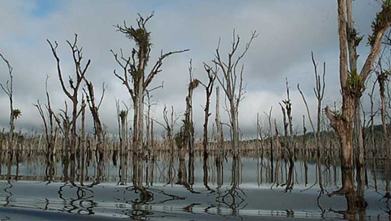
The Tucuruí dam, on the Tocantins River in the State of Pará, Brazil, began operating in 1984. Flooding a total of 3,014 square kilometers (1164 square miles), and with a generating capacity of 8,370 megawatts, it is one of the largest in the world. The study, led by Gang Chen of the University of North Carolina, focused on forest cover between 1988-2013, and used a combination of remote sensing and GIS techniques to assess when and where deforestation and forest degradation occurred over an 80,000 square kilometer (30,888 square mile) area surrounding the dam. Three ‘neighborhoods’ were delineated within this area by the researchers, defined as being upstream, in the vicinity of, and downstream of the dam.
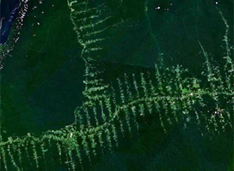
“At the spatial resolution of 30 meters [98 feet], Landsat imagery is sufficient to detect largescale deforestation, but is too coarse to directly reveal the degree of forest degradation that typically occurs at the sub-pixel level,” the authors state. To overcome this limitation, the team extracted information from each pixel that indicated how much photosynthetic material and bare earth was present, making it possible to estimate how much degradation — the loss of tree stems from within the forest — had occurred.
From 1988 until 2008, the study area around the dam lost an average of 591-660 square kilometers (228-255 square miles) of forest each year. From 2008-2013, deforestation fell to 325 square kilometers (125 square miles) per year, a drop the authors ascribe to slowing in the global economy and to improved Brazilian law enforcement against illegal logging.
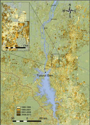
The researchers also found that throughout the entire study period forest degradation affected an average of 102 square kilometers (39 square miles) per year. Spatial patterns of deforestation and degradation were similar, with more forest disturbance found in the vicinity and upstream of the dam, than downstream.
The authors assert that one of the main factors contributing to increased forest loss was the settlement of thousands of people into formerly forested areas around the dam — including many laborers who resettled in the area during the dam’s construction, plus locals forced to relocate when their homes and lands were flooded by the dam’s reservoir. In addition “with new roads constructed to connect ever-growing cities around the dam, timber production also became economically feasible,” the authors state.
The researchers caution that, lacking a control study area for comparison, they could not quantify the degree to which the dam’s construction was responsible for driving deforestation, as opposed to the deforestation that might have occurred anyway without the dam due to widespread development within the region.
“Building dams can lead to human resettlement, which [has] a direct impact on forest. But it is difficult to say how it affects commercial/selective logging, another important activity causing deforestation,” Chen told mongabay.com. “Road construction may be facilitated by dam construction, but some roads may still be constructed at a later time if no dams exist.”

The proper way to accurately identify and quantify the main driving factors behind deforestation due to dams, said Chan, would be to compare deforestation among the neighborhoods of various sized existing Amazon dams, and then do statistical modelling. Such a comparison was beyond the scope of the Tucuruí study, but would be valuable to understanding specifically how tropical dams contribute to deforestation long term.
Claudia Stickler, a scientist at California’s Earth Innovation Institute, has studied forest and land-use policy in the Xingu River Basin, site of the controversial Belo Monte mega-dam. Stickler, who was not involved with the Tucuruí study, cautioned that a number of confounding issues would need to be disentangled in order to understand the role of the dam in the observed changes in forest cover. She emphasised the importance of considering a range of factors “that are known to drive deforestation generally and in that part of the Amazon specifically, and that were likely to have coincided with the presence of the dam — e.g., new roads, paving, population growth in the region generally, development policies in the region — all of this independent of the construction of the dam, [but] all part of development and expansion in the region.”
“While it’s clear that large infrastructure projects do drive localized deforestation and forest degradation, at a minimum, further studies need to be carried out to look at the extent to which projects like this might be driving deforestation over larger areas and over longer periods of time,” Stickler told Mongabay.
Chen intends to go beyond the Tucuruí study to investigate these questions. “The future plan will be exploring the spatiotemporal patterns of forest changes in the neighborhoods of several other major dams in the Amazon. We would like to know how such patterns differ across dams and what factors have caused the potential variation,” Chen explained.
If the deforestation impacts of existing Amazon dams become better understood, there will be a better chance of employing mitigation strategies to minimize them around future dams. “To find mitigation solutions, first we need to know how much has changed — [as seen in our Tucuruí paper]; and second, we need to determine the main driving physical and socio-economic factors behind the change — our objective of the next step of research,” Chen said. “The factors and their relative importance are more important to decision makers.”
Whatever the precise causes of deforestation, it is known that the loss of forest cover across the Amazon rainforest has important but often overlooked impacts on the water cycle which are detrimental to the generating capacity of hydroelectric dams.
Stickler and her colleagues were the first to formally quantify the direct and indirect impacts of deforestation on river discharge and energy production for the Belo Monte dam, in a paper published in PNAS in 2013.

Local deforestation has typically been regarded as beneficial to water flow, and therefore energy production, because evapotranspiration — the movement of water from soil and plants back into the atmosphere —decreases if trees are cut down. However, broader impacts have been ignored. Stickler’s team showed that predicted deforestation throughout the Amazon basin would result in lower rainfall across the region — the rainforest generates about half its own water supply — leading to lower river levels, outweighing any positive local effects due to deforestation, and significantly reducing the power that could be generated by Belo Monte. That’s a finding that would likely extend to other Amazon dams.
This new research, showing the fundamental connection between lost forest cover and decreased hydroelectric production, has not however been taken into account when new dams are planned, and the message is still not reaching decision makers two years after the Belo Monte study. “Unfortunately, I think the issue of the impacts of deforestation and deforestation-driven climate change on hydroelectric energy generation is still not integrated into policy discussions and planning for existing or new hydroelectric plants,” Stickler commented. Proposed dams “need to be thought of in a broader context of climate and forest (or conservation) policy, as well as in the context of social policy.”
Stickler sees the deforestation reported by Chen’s team as significant enough to impact rainfall levels, but says that the problem is much, much bigger. “I don’t think that the deforestation in the relatively small study area is the biggest concern, but rather the whole swathe of deforestation on this eastern edge of the Amazon basin,” Stickler said.
“Better planning is needed to make sure that the projects don’t come with excessive negative local impacts, socially and environmentally,” she concluded. “This seems to be not so much a question of know-how, but of political will, of the willingness of governments to put the long-term good of local communities and regional society in first place, and to hold contractors and engineers to higher standards of accountability.”
Citations:
Chen, G., Powers, R.P., de Carvalho, L.M.T., Mora, B. (2015). Spatiotemporal patterns of tropical deforestation and forest degradation in response to the operation of the Tucuruí hydroelectric dam in the Amazon basin. Applied Geography, 63: 1–8
Stickler, C.M., Coe, M.T., Costa, M.H., Nepstad, D.C., McGrath, D.G., Dias, L.C.P., Rodrigues, H.O., and Soares-Filho, B.S. (2013). Dependence of hydropower energy generation on forests in the Amazon Basin at local and regional scales. PNAS, 110: 9601–9606
La Rovere, E.L. and Mendes, F.E. (2000). Tucuruí Hydropower Complex, Brazil, A World Commissions on Dams case study prepared as an input to the World Commission on Dams, Cape Town, www.dams.org