
- Indonesian forestry giant Asia Pulp & Paper announces a peatland management program.
- APP will retire 7,000 ha of acacia plantations in five sensitive peat areas, allowing forests to recover.
- APP has also commissioned LiDAR work that will produce a 4.5 million ha map of Sumatran peatlands.
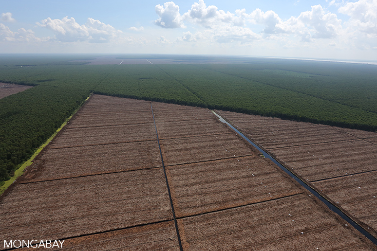
In a notable shift away from business-as-usual in Indonesia’s plantation sector, forestry giant Asia Pulp & Paper Group (APP) will undertake ecosystem restoration in 7,000 hectares of commercial timber plantations, converting acacia back to native peatland species as part of a broader peatland management program.
The move, announced at a press conference in Jakarta on Thursday, represents the next step in APP’s efforts to reform its forest management practices, which were long a target of criticism by environmental groups. More importantly, the initiative could have far broader implications in Indonesia by establishing best practices for peat management and pressuring the government and other private sector players to curb ongoing destruction of peatlands across Sumatra, Borneo, and New Guinea.
Deforestation and degradation of peatlands are a major source of greenhouse gas emissions in Indonesia and a key driver of the choking “haze” that periodically blankets Southeast Asia. Drainage to peatlands is also causing large areas of coastal land in Sumatra to sink or subside, increasing the risk of flooding.

The new initiative is called the Peatland Best Practice Management Programme, which falls under the Forest Conservation Policy (FCP) APP established in 2013 in response to heated criticism from environmentalists. The program involves a phased approach, the first elements of which are being led by Deltares, a Dutch consultancy with expertise in wetlands-related issues.
The first step involves mapping the vast areas of peatlands in Riau, Jambi, South Sumatra, and West Kalimantan where APP has the bulk of its plantations. Deltares used airplane-based LIDAR, a remote sensing technology that utilizes lasers to construct a highly accurate three-dimensional representation of features below, including vegetation structure, elevation, and water levels in canals to understand the extent and depth of peatlands as well as forest cover. Flying 11,000 kilometers of transects, the effort will produce a comprehensive peat model for 4.5 million hectares of land, including APP concessions and surrounding areas.

While the maps won’t be finalized until next year, the initial findings are significant. For example, the survey found that the few remaining major forest areas along the east coast of Sumatra are all on deep peat. And of the five forested peat domes — areas of particularly deep peat — four are in Riau, none of which are formally protected. The fifth is located in Berbak and Sembilang National Parks in Jambi and South Sumatra.
Critically, the LIDAR work showed that APP concessions are present on five forested peat domes, indicating that the company “has a unique opportunity to support peatland forest conservation and emission reduction,” according to Deltares, which recommended that it move to retire plantations in several especially sensitive locations, where peat drainage and degradation is having a substantial impact on forested domes.

APP is taking those recommendations to heart, announcing today that it will move to retire plantations in five areas, including one area in Kerumutan, Riau and four areas in the Berbak-Sembilang landscape in Jambi and South Sumatra.
“APP’s decision to retire these areas of commercial plantation is an important milestone in the delivery of our Forest Conservation Policy and we believe it is an unprecedented commitment,” said Aida Greenbury, Managing Director Sustainability, in a statement. “The retirement of active plantations is not an easy decision for any business to take, but we believe that taking urgent steps to protect remaining areas of peatland forest, as well as reducing and avoiding climate emissions from peatlands, must be a priority. While there is still a long way to go, and we have much to learn, this announcement today represents a major breakthrough.”


But it may not be as easy as simply blocking drainage canals and letting water levels rise and forest recover. For one, APP will first have to conduct a Free and Prior Informed Consent (FPIC) process with local communities to ensure their wishes are respected. Greenbury noted that some communities might oppose APP blocking canals that are use for transport and access.
Secondly, some of the areas are highly degraded, meaning that dams will need to be carefully planned and the restoration process potentially facilitated by active replanting. APP says the effort is intended to be a pilot so lessons can be drawn on what approaches work best under given circumstances. In some areas APP will use enrichment planting with native swamp trees, while in others it will let nature take its course without intervention other than felling the acacia trees.
That work could eventually inform other projects that aim to rehabilitate peatlands. More broadly, the mapping component of the program could help the Indonesian government and other companies identify peatlands that should be restored or off-limits to development.
The timing of such information is critical: the Indonesian government is currently weighing a measure that would weaken peatlands protection, while a number of plantation companies — ranging from palm oil giant Wilmar to APP’s biggest competitor APRIL — are making commitments to better manage, and avoid conversion of, peatlands.
APRIL declined to comment on APP’s initiative, but Wilmar told Mongabay it is “very interested” in learning more about its work. The palm oil company added that it currently uses guidelines established by the Roundtable on Sustainable Palm Oil (RSPO) for managing peatlands to minimize greenhouse gas emissions.
APP’s Greenbury welcomed wider engagement.
“Saving 7,000 hectares of peat forest does nothing if it doesn’t lead others to take action,” Greenbury told Mongabay. “We’re very proud of what we’ve achieved so far, but we cannot do alone.”
“APP’s goal of supporting the conservation of forest and peat landscapes needs to be a shared objective, and one supported by meaningful actions from both the Government and other plantation companies,” she added in a prepared statement. “This should include addressing the systemic barriers to forest and peatland protection, supporting forest restoration and ensuring development opportunities for communities.”
The broader applications of the work were echoed by Aljosja Hooijer, the project lead at Deltares.
“APP has a unique opportunity to support peatland forest conservation and emission reduction,” he said in a statement. “The progress announced today is a first step in a process towards the development of a new model to define best management practices in peatlands. The pioneering approach to collecting LiDAR data has allowed the technology to be deployed at an unprecedented scale economically, and will advance the science of peat and peat management not only in Indonesia, but also globally.”
Greenpeace — once APP’s fiercest critic but now a key partner in its reform efforts — agreed with the potential ramifications of the program.
“This project is very important for Indonesia,” Bustar Maitar, Global Head of Greenpeace International’s Indonesia Forest Campaign, told mongabay.com. “Peatland is one of the biggest opportunities we have to address climate change but so for no one has a good idea to manage peatlands. This will provide a strong view of how to tackle peatlands emissions and how to deal with existing plantations on peatland — both timber and palm oil plantations.”
He added that the open nature of the process will make it hard for companies to claim “a need for further research” as an excuse for not adopting better practices.
“I think this will guide the government to develop a stronger policy on peatland management,” he said.

Engaging the Indonesian government on the issue is critical. Regulations currently governing peatlands — including PP71, a regulation adopted last year — are confusing and open to interpretation, often leading to them being ignored. Furthermore, these regulations may be getting worse: an academic paper published earlier this month by the Ministry of Environment and Forestry seems to propose locking Indonesia into a significant expansion of peatlands drainage.
Greater clarity on where peatlands are really located, how they are being affected by land use activities, and practical strategies for their management could thus serve to better align the central government’s commitment to curb business-as-usual emissions up to 41 percent by 2020 with what’s actually needed on-the-ground in terms of policy and implementation. A key assumption however is that the data provided to the Indonesian government under the program will be made publicly available.
Nur Masripatin, Director General of Climate Change at the Ministry of Environment and Forestry, didn’t seem to think that would be an issue, despite the potential sensitivity for some companies operating in peatland areas.
“Actually, [it is] no problem,” Nur told Mongabay. “The [data] can be more input for the One Map [process]”. The One Map process is an effort to reconcile all the spatial information across all relevant ministries in Indonesia to create a single accurate map of land use and rights.

Ida Bagus Putera, the Director General of Sustainable Forest Management at the Ministry of Environment and Forestry, added that APP’s initiative could significantly reduce carbon emissions, while supporting the government’s climate change commitment. It could also provide insight on how to boost productivity of the timber sector without expanding into sensitive areas.
“Land is not an abundant resources in Indonesia,” Ida said. “The important thing is intensification, not expansion.”
APP’s Greenbury seemed to agree with that assessment.
“With the signing of the Forest Conservation Policy in 2013, APP committed to support the government’s target to reduce greenhouse gas emissions,” Greenbury told Mongabay. “We are making steady progress toward that goal while at the same time increasing productivity without clearing more forests. This new program is an important step further down that path by establishing a better model to protect peatlands and forests.”