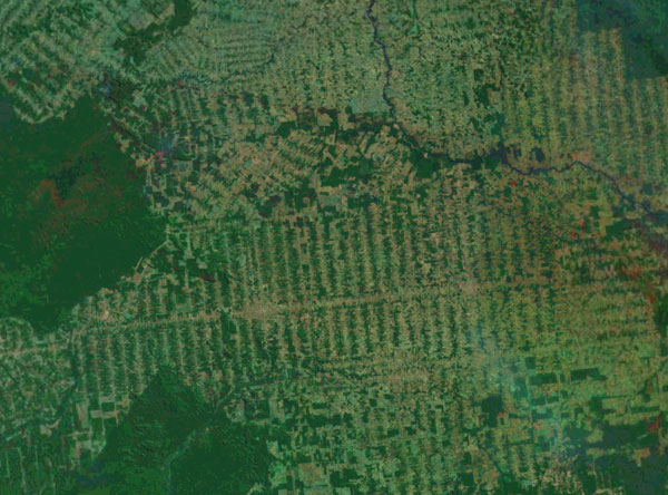
Landsat image showing deforestation in the Brazilian Amazon.
With scientists rapidly adopting and using a range of remote sensing tools for monitoring environmental change, tracking wildlife and measuring biological processes, conservation needs to scale up networking capabilities to maximize the potential of this technological revolution, argues a commentary published in the journal Science.
NASA’s Woody Turner breaks sensing technologies into two scales: remote sensing platforms like satellites and airplanes, and in-situ devices like camera traps, drones, phones, tags, and sensors.
“Remote sensing involves a wide array of tools and techniques on orbiting satellites and flying aircraft,” he writes. “It enables directly observing large-scale ecosystems and large organisms, depicting the broader environmental context for biodiversity, tracking climatic and other drivers of biodiversity change (often for use in ecological models), and making consistent observations across time and space for biodiversity monitoring.”
“Remote sensing is increasingly complemented by in situ sensing with cameras on stationary objects or small drones, sound recorders, cell phones, electronic tags, and fragments of genetic material sampled directly from the environment.”

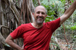
Camera trap in Costa Rica
Turner says conservation effort would benefit from increased coordination between remote sensing and in situ approaches. But this isn’t a simple undertaking.
“The data from satellites, aircraft, and in situ sensors cover a vast range of spatial scales. Use of these sensing data in concert requires sophisticated networking and geostatistical analysis to fill gaps between fine-scale organismal or genetic observations and ecosystem-scale observations. Similar networks are necessary to tie biodiversity observations to data on broader environmental drivers of change,” he writes.
“Scale is not the only issue. The multitude of sensor types used to measure elements of biodiversity even at the same spatial scale further complicates networking, as does the integration of information from models. All observations and models come with their individual uncertainties, which must be addressed by any networking framework.”

Image courtesy of SCIENCE.
Turner notes that initiatives to coordinate data collection and monitoring across various scales are currently in their infancy, but nonetheless moving forward. He points to the National Ecological Observatory Network (NEON), a program being developed by the United States to collect environmental data across 20 “eco-climatic domains”, as well as an international program under the Group on Earth Observations (GEO).
“The international Group on Earth Observations (GEO) partnership, particularly its global Biodiversity Observation Network (GEO BON), is a first attempt by national governments to jointly coordinate satellite, airborne, and in situ observations across biodiversity elements through genes, species, and ecosystems,” he writes. “This effort is crucial for meeting governments’ obligations to assess national biodiversity under the Convention on Biological Diversity and the Intergovernmental Platform on Biodiversity and Ecosystem Services.”
CITATION: Woody Turner. Sensing biodiversity. SCIENCE 17 OCTOBER 2014. VOL 346 ISSUE 6207
Related articles
World’s rainforests could be mapped in 3D at high resolution by 2020 for under $250M

(09/05/2014) Mapping the world’s tropical forests with a fleet of airplanes outfitted with advanced LiDAR could rapidly and accurately assess global forest carbon stocks for a fraction of the cost of a typical Earth observation satellite mission — and far less than field-based sampling — argues a new paper published in Carbon Balance and Management.
Next big idea in forest conservation? DNA fingerprinting trees to stem illegal logging
(08/21/2014) As a professor at Texas Tech, Dr. Chuck Cannon has been, among other things, working to create a system of DNA fingerprinting for tropical trees to undercut the global illegal logging trade. ‘If we just enforced existing laws and management policies, things would be pretty good, but unfortunately, that is where things fall apart in many tropical countries,’ Cannon said.
Discarded cell phones to help fight rainforest poachers, loggers in real-time

(06/24/2014) A technology that uses discarded mobile phones to create a real-time alert system against logging and poaching will soon be deployed in the endangered rainforests of Central Africa. Rainforest Connection (RFCx), a San Francisco-based non-profit startup, is partnering with the Zoological Society of London (ZSL) to install its real-time anti-deforestation technology at sites in Cameroon. 30 RFCx devices — recycled from old Android handsets — will monitor 10,000 hectares or nearly 40 square miles of rainforest, listening for audio signals associated with logging and poaching.
Next big idea in forest conservation? Empowering everyone to watch over forests

(04/10/2014) Nigel Sizer has worked on the forefront of global forest issues for decades. Currently, he is the Global Director of the World Resource Institute’s (WRI) Forests Program, whose projects include the Global Forest Watch, the Forest Legality Alliance, and the Global Restoration Initiative. These programs work with governments, businesses, and civil society with the aim of sustaining forests for generations to come.
Revolutionary Google-backed system unlocks power of ‘big data’ to save forests
(02/20/2014) World Resources Institute (WRI) today announced the release of a tool that promises to revolutionize forest monitoring. The platform, called Global Forest Watch and developed over several years with more than 40 partners, draws from a rich array of big data related to the word’s forests and translates it into interactive maps and charts that reveal trends in deforestation, forest recovery, and industrial forestry expansion. Global Forest Watch is the first tool to monitors global forests on a monthly basis, allowing authorities and conservationists to potentially take action against deforestation as it is occurring.
Next big idea in forest conservation? Using drones to catch poachers, monitor forests

(01/24/2014) At the foothills of the Himalayas, elephants, rhinoceroses, and tigers stir in the green forests. Protecting and monitoring these animals and the health of tropical forests worldwide is a significant challenge, often requiring large amounts of time, money and risk. Fortunately, an affordable new tool is soaring into the conservation sphere: autonomous flying vehicles, or drones. Lian Pin Koh, is a founding director of the non-profit ConservationDrones.org, which builds capacity in the use of drones for conservation in the developing tropics.
Big data shows tropical mammals on the decline
(12/12/2013) The world’s largest remote camera trap initiative—monitoring 275 species in 17 protected areas—is getting some big data assistance from Hewlett-Packard (HP). To date, the monitoring program known as the Tropical Ecology Assessment and Monitoring (TEAM) Network has taken over 1.5 million photos of animals in 14 tropical countries, but conservationists have struggled with how to quickly evaluate the flood of data.
Video: the conservation drone revolution
(11/29/2013) The use of small autonomous flying vehicles — model airplanes to hobbyists — is revolutionizing the field of conservation, enabling researchers to track wildlife, monitor for poachers, and survey inaccessible forests and reefs.