Land cleared for mines spotted by innovative mapping technology
Gold mining is on the rise in the Guiana Shield, a geographic region of South America that holds one of the world’s largest undisturbed tract of rainforest. Mining is a key driver of forest cover change, and while deforestation rates from mining remain lower overall in the Guiana Shield than in some other areas in South America, this region, with its unique biodiversity and expansive areas of connected forests, is certainly a place to watch.
And watching we are. SarVision, a spin-off from Wageningen University in the Netherlands, is employing the best use of open data by processing both radar and common optical satellite imagery (e.g., Landsat) to significantly improve monitoring techniques for the Guiana Shield region. Mongabay.com spoke with Niels Wielaard, executive director of SarVision about these new monitoring techniques and the mining situation in the Guiana Shield.

Spatial distribution of forest cleared for mining expansion in the Guiana Shield during the period 2000-2013 (red). Result based on semi-automated analysis of more than 2,500 satellite images (MODIS, Landsat and ALOS PALSAR). Image processing: SarVision. Satelite imagery courtesy of USGS/NASA, JAXA/METI. Click to enlarge.
“We have now developed the most comprehensive mining-specific forest loss dataset to date, with unprecedented geographic and temporal coverage (i.e., the entire Guiana Shield and annually for 2000-2013, with current updates in the works),” Wielaard said. “This has not been available before. Our tentative results show that [mining] expansion is still increasing rapidly…”
Forest change can be tracked through satellite imagery. However, satellites require a clear view to get good photos. Radar, on the other hand, can peer through clouds that obscure the ground below and detect surface changes that are invisible to the naked eye.
“Given the persistent cloud cover hampering commonly used satellites in this part of the world, radar sensors that penetrate clouds can make a difference for timely and consistent monitoring of change…” Wielaard said. “Radar’s sensitivity to soil moisture helps to better detect small-scale mining sites. We found that with optical time-series we should also for the first time be able to track increased sedimentation of streams due to mining expansion. This opens up new possibilities for more systematic water quality monitoring.”

The Guiana Shield. Photo courtesy of Biological Diversity of Guiana Shield. Click to enlarge.

About two million hectares of tree cover were lost from 2001 through 2012, from the approximately 200 million-hectare forested area overlying the Guiana Shield, according to data from Global Forest Watch. While large tracts of intact forest still dominate the landscape, sections along its edges have been degraded since 2000. Map courtesy of Global Forest Watch. Click to enlarge.
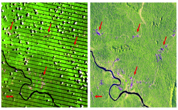
Left: mining areas detected in pink-white (see red arrows) in a Landsat7 image taken September 2008. Clouds (white) and cloud shadows (black) are visible, as well as black lines due to permanent satellite malfunction. Right: mining areas detected in pink-blue (red arrows) using PALSAR imagery captured July 2007. The area shown is approximately 33-by-27 kilometers. Click to enlarge.
Mining in the Guiana Shield is driven by multinational mining companies, as well as artisanal and small-scale gold mining operations. While it is nearly impossible to track the flow of gold out of the country, the Brazilian company Ourominas is a well known big buyer of gold in South America, and some is likely going into the local jewelry sector.
Gold prices skyrocketed during the last decade, increasing about 500 percent between 2000 and 2011 to more than $1,900 per ounce. This trend looks to be leveling, but not before encouraging mining outfits to set up shop and reap some profit.
“We assume that the increase in global gold price in reaction to the financial crisis has been an underlying factor [of mining expansion],” Wielaard told mongabay.com. “Some observers I talked to speculate that an increase of Brazilian [prospectors] fleeing poverty and strict law enforcement against illegal mining in other parts of Brazil and Maroons in Suriname and French Guiana are seizing opportunities to employ them to get the gold out, coinciding with increased availability of (smuggled) mercury, might be a cause, or an effect.”


Click to enlarge.
The Guiana Shield is a tectonically stable, ancient portion of the South American plate, which encompasses the countries of Guyana, Suriname, French Guiana, and parts of Brazil, Venezuela and Columbia. Over 20,000 species of plants are found in the Guiana Shield ecoregion, over one-third of which are endemic and found nowhere else in the world. The Guiana Shield ecoregion contains some of the most carbon-rich forests in South America and represents an important sink for CO2.
Animal diversity is similarly high in the region. Birds are especially plentiful, with 975 species found in the region, more than 70 of which are endemic. So far, more than 225 species of mammals have been identified in the region, including two types of dolphin, two manatee species and 13 types of primates. Over half of the overall mammal diversity, however, is of made up of bats—146 species and counting. Of the mammals, roughly 10 percent (29 species) are classified as threatened by the IUCN, including the two endemic primates in the region: the red-faced spider monkey (Ateles paniscus) and the white-faced saki (Pithecia pithecia).

A male white-faced saki (Pithecia pithecia) in captivity. This is one of the two primate species endemic to the Guiana Shield region. Photo by Hans Hillewaert.
According to data from Global Forest Watch, the total forest loss in the Guiana Shield from 2001 through 2012 amounted to about two million hectares of the shield’s approximately 200 million-hectare area. In other words, about 1 percent of the Guiana Shield was deforested in just over a decade.
For more than 20 years, Sarvision has worked with local NGOs, such as the Guiana Shield Facility, www.guianashield.org, to improve overall monitoring of this area.
“We hope [Sarvision’s monitoring] provides a basis for more systematic monitoring in support of responsible mining and sustainable supply chain marketing, spatial planning, and payment for ecosystem services such as clean water,” Wielaard said. “Local communities using low cost hand-held technology to sample forest and water quality parameters should also play a role.”

A subspecies of the Amazon River dolphin (Inia geoffrensis) inhabits the rivers of the Guiana Shield. Also referred to as the “boto,” this species was previously listed as Vulnerable by the IUCN due to human threats, but its status is now “Data Deficient.” Photo by Allen Sheffield.
}}
Related articles
Top scientists raise concerns over commercial logging on Woodlark Island
(10/21/2014) A number of the world’s top conservation scientists have raised concerns about plans for commercial logging on Woodlark Island, a hugely biodiverse rainforest island off the coast of Papua New Guinea. The scientists, with the Alliance of Leading Environmental Scientists and Thinkers (ALERT), warn that commercial logging on the island could imperil the island’s stunning local species and its indigenous people.
‘River wolves’ recover in Peruvian park, but still remain threatened inside and out (photos)

(10/14/2014) Lobo de río, or river wolf, is the very evocative Spanish name for one of the Amazon’s most spectacular mammals: the giant river otter. This highly intelligent, deeply social, and simply charming freshwater predator almost vanished entirely due to a relentless fur trade in the 20th Century. But decades after the trade in giant river otter pelts was outlawed, the species is making a comeback.
Under pressure over pollution complaints, Aceh calls for closure of gold mines
(08/22/2014) In the wake of massive fish die-offs and repeated calls from environmental groups to do more than just talk about the issue, the government of Aceh has called for the closure of all illegal gold mines throughout the province. Several members of the Regional Leadership Coordination Forum signed a written appeal for illegal miners to immediately stop their operations.
Aceh backtracking on mining moratorium, continues to issue permits

(08/13/2014) The Governor of Aceh Province, Indonesia appears unwilling to implement a mining moratorium, despite repeated statements he intends to do so. Governor Zaini Abdullah, a co-founder of the separatist Free Aceh Movement (GAM), has said on several occasions that he believes there should be a moratorium on mining licenses, however watch-groups claim no official policy has been enacted.
A paradise being lost: Peru’s most important forests felled for timber, crops, roads, mining

(08/12/2014) In 1988, when British environmentalist Norman Myers first described the concept of a “biodiversity hotspot,” he could have been painting a picture of the highly threatened Peruvian Andes mountain range. Today, the Andes are an immediate and looming portent of the fate of the Peruvian Amazon rainforest.