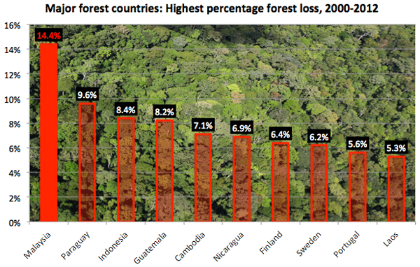
Malaysia had the world’s highest rate of forest loss between 2000 and 2012, according to a new global forest map developed in partnership with Google.
Malaysia’s total forest loss during the period amounted to 14.4 percent of its year 2000 forest cover. The loss translates to 47,278 square kilometers (18,244 square miles), an area larger than Denmark.
Malaysia’s forest loss was partly offset by a 25,978 sq km gain in vegetation cover resulting from natural recovery, reforestation, and establishment of industrial timber and oil palm plantations. During the period, Malaysia’s oil palm estate grew by roughly 50 percent or 17,000 sq km.
But tree plantations don’t stack up well to natural forests into terms of biodiversity, carbon storage, or maintenance of ecosystem services, indicating that Malaysia suffered very extensive decline of its natural capital base. Most of Malaysia’s forest loss occurred in its densest forests, those with tree cover exceeding 50 percent, which generally store the most carbon and are richest with wildlife, including endangered orangutans, pygmy elephants, Sumatran rhinos, and clouded leopards.

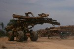
After decades of unsustainable logging, which depleted timber stocks and undermined the viability of traditional forestry management, Malaysia’s forests are increasingly being converted for industrial oil palm plantations. The palm oil industry is a powerful political force in the country.

Summary of land use change in Malaysia (bottom). Left column: land use prior to the establishment of new oil palm plantations (in the lower left corner is the total annual increase in oil palm plantations). Middle column: the fate of land following forest conversion (in the lower left corner is the annual rate of deforestation). Right column: net land use change over each five year period. From Historical CO2 emissions from land use and land cover change from the oil palm Industry in Indonesia, Malaysia and Papua New Guinea
Dan Zarin, program director of the Climate and Land Use Alliance, an association of philanthropic foundations, says trading natural forests for planted forests represents a net loss for the planet.
“You can’t ‘net out’ deforestation by planting trees,” said Zarin, “because newly planted forests are far less valuable for carbon, biodiversity and forest-dependent people than standing native forests.”
Malaysia’s rate of forest loss during the period was nearly 50 percent higher than the next runner up, Paraguay (9.6 percent). Its area of forest loss ranked ninth after Russia, Brazil, the United States, Canada, Indonesia, China, the Democratic Republic of Congo, and Australia. Malaysia’s net forest loss — 21,480 sq km — ranked 12th globally.
The data was released in a breakthrough map developed by a team of researchers from the University of Maryland, Google Inc, NASA, USGS, South Dakota State University, the Woods Hole Research Center, and the Gordon and Betty Moore Foundation Foundation. The map, which is detailed in today’s issue of the journal Science, is based on 650,000 images captured by NASA Landsat cameras at 30 meter resolution.

Clarifying Google’s forest map |
According to the project’s led developer, Matthew Hansen of the University of Maryland, the map represents a significant advancement toward understanding ecological changes that accompany changes in forest cover.
“This is the first map of forest change that is globally consistent and locally relevant,” said Hansen. “Losses or gains in forest cover shape many important aspects of an ecosystem including, climate regulation, carbon storage, biodiversity and water supplies, but until now there has not been a way to get detailed, accurate, satellite-based and readily available data on forest cover change from local to global scales.”

Forest loss in Peninsular Malaysia. Some of Malaysia’s forest loss included replanting of existing plantations — the current version of the map does not distinguish between natural forest cover and plantations.
Hansen adds the tool could be used to develop and implement policies to reduce deforestation.
“Brazil used Landsat data to document its deforestation trends, then used this information in its policy formulation and implementation,” said Hansen. “Now, with our global mapping of forest changes every nation has access to this kind of information, for their own country and the rest of the world.”
Whether Malaysia decides to use the information for that purpose remains to be seen.

Related articles
Powered by Google, high resolution forest map reveals massive deforestation worldwide

(11/14/2013) Researchers today released a long-awaited tool that reveals the extent of forest cover loss and gain on a global scale. Powered by Google’s massive computing cloud, the interactive forest map establishes a new baseline for measuring deforestation and forest recovery across all of the world’s countries, biomes, and forest types. The map has far-reaching implications for efforts to slow deforestation, which accounts for roughly ten percent of greenhouse gas emissions produced by human activities, according to the authors of the paper that describes the tool and details its first findings.
3.5 million ha of Indonesian and Malaysian forest converted for palm oil in 20 years

(11/12/2013) Some 3.5 million hectares (8.7 million acres) of forest in Indonesia, Malaysia, and Papua New Guinea was converted for oil palm plantations between 1990 and 2010, finds a comprehensive set of assessments released by the Roundtable on Sustainable Palm Oil (RSPO). The research, conducted by an international team of scientists from a range of institutions, is presented in a series of seven academic papers that estimate change in land use and greenhouse gas emissions from oil palm expansion in the three countries, review the social and environmental impacts of palm oil production, forecast potential growth in the sector across the region, and detail methods for measuring emissions and carbon stocks of plantations establishing on peatlands.
Malaysia clearcutting forest reserves for timber and palm oil
(09/26/2013) In July Bikam Permanent Forest Reserve in Malaysia’s Perak state was degazetted, allowing the forest to be clearcut for an oil palm plantation. Only after the forest was lost, did the Forest Research Institute Malaysia (FRIM) announce that it had contained the last stands of keruing paya (Dipterocarpus coriaceus) on the Malay peninsula, a large hardwood tree that’s classified as Critically Endangered on the IUCN Red List. The species is now reportedly extinct in Malaysia, although may still be found in Indonesia. However, the degazettement of the 400-hectare Bikam Forest Reserve wasn’t an abnormality, according to activists. Since 2009, over 9,000 hectares of Permanent Forest Reserves have been degazetted in northwestern state, wiping out not just trees, but undercutting protected mammals and birds while threatening watersheds.
80% of rainforests in Malaysian Borneo logged

(07/17/2013) 80 percent of the rainforests in Malaysian Borneo have been heavily impacted by logging, finds a comprehensive study that offers the first assessment of the spread of industrial logging and logging roads across areas that were considered some of Earth’s wildest lands less than 30 years ago. The research, conducted by a team of scientists from the University of Tasmania, University of Papua New Guinea, and the Carnegie Institution for Science, is based on analysis of satellite data using Carnegie Landsat Analysis System-lite (CLASlite), a freely available platform for measuring deforestation and forest degradation. It estimated the state of the region’s forests as of 2009.
NASA: Deforestation jumps in Malaysia
(06/10/2013) Deforestation jumped during the first three months of 2013 in Malaysia, Nepal and Mexico, according to a forest tracking tool developed by a team of NASA researchers.
Industrial logging leaves a poor legacy in Borneo’s rainforests

(07/17/2012) For most people “Borneo” conjures up an image of a wild and distant land of rainforests, exotic beasts, and nomadic tribes. But that place increasingly exists only in one’s imagination, for the forests of world’s third largest island have been rapidly and relentlessly logged, burned, and bulldozed in recent decades, leaving only a sliver of its once magnificent forests intact. Flying over Sabah, a Malaysian state that covers about 10 percent of Borneo, the damage is clear. Oil palm plantations have metastasized across the landscape. Where forest remains, it is usually degraded. Rivers flow brown with mud.
Charts: deforestation in Indonesia and Malaysia, 2000-2010
(07/15/2012) Indonesia and Malaysia lost more than 11 million hectares (42,470 square miles) of forest between 2000 and 2010, according to a study published last year in the journal Global Change Biology. The area is roughly the size of Denmark or the state of Virginia. The bulk of forest loss occurred in lowland forests, which declined by 7.8 million hectares or 11 percent on 2000 cover. Peat swamp forests lost the highest percentage of cover, declining 19.7 percent. Lowland forests have historically been first targeted by loggers before being converted for agriculture. Peatlands are increasingly converted for industrial oil palm estates and pulp and paper plantations.