
Researchers working in Panama have produced the most accurate carbon map for an entire country.
Using satellite imagery and extremely high-resolution Light Detection and Ranging (LiDAR) data from airplane-based sensors, a team led by Greg Asner produced a detailed carbon map across the Central American country’s forests. The map reveals variations in forest carbon density resulting from elevation, slope, climate, vegetation type, and canopy coverage. Overall the highest carbon density — often exceeding 110 tons of carbon per hectare — was found in rainforests on the Caribbean side of Panama.
The study, which is published in the current issue of the journal Carbon Balance and Management, utilized a large body of field data collected by scientists at the Smithsonian Tropical Research Institute (STRI), which is based in Panama. Asner’s team used this data to calibrate their LiDAR-based system, which maps forest structure at one meter resolution. The team then flew dozens of tracks across Panama and combined the resulting data with imagery captured by NASA’s Landsat satellites to scale up the plots country-wide. The result is a carbon map that covers every hectare of Panama and is far more accurate the assessments based only on satellite data.
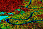
 Major remote sensing inputs to the national carbon mapping study. (a) LiDAR flight coverage obtained by Carnegie Airborne Observatory, including systematic sampling designed to achieve robust coverage of national ecosystems, plus additional samples added as time and weather permitted, and three large validation areas set aside to evaluate national mapping approaches. (b) CLASlite fractional cover based on a mosaic of 158 Landsat scenes, and MODIS data in areas of poor Landsat coverage. Image is a red-green-blue composite, with % bare soil or substrate coverage shown in red, % photosynthetic vegetation (PV) shown in green, and % non-photosynthetic vegetation (NPV) shown in blue. |
“Three things make this national-scale study unique,” said Asner in a statement. “First, Panama is an outstanding place for testing carbon mapping approaches due in part to the long-term forest studies that have been undertaken by our partners at the Smithsonian Tropical Research Institute (STRI). Second, we have applied the very latest techniques using high-performance instrumentation, resulting in demonstrably high accuracy at fine spatial resolution. And third the partnership permitted us to estimate our errors in a novel way, and we did so over every point on Panamanian soil.”
The findings will be useful as Panama moves toward implementing a national Reducing Emissions from Deforestation and Degradation (REDD+) program, by helping reduce uncertainty about carbon stocks and establishing a clear baseline for measuring progress in curbing forest loss.
“Panama is one of the first UN REDD partner countries, and these new maps put the country at the forefront of high-resolution ecosystem management,” said co-author and STRI’s director Eldredge Bermingham in a statement. “The new carbon mapping approach could be the model for other tropical nations.”
The approach is also potentially cost-effective, especially when it can leverage existing field data, according to the study.
“Field plots are extremely expensive to establish and maintain, for example, costing the Carnegie Institution (a non-profit with no program overhead costs) from $2000-$5000 USD per hectare in basic plot setup and measurement,” the authors write. “Our costs for data collection and analysis would have been less than $600,000 USD, or about $1.00 USD per hectare covering nearly 600,000 hectares for national ‘inventory’, plus calibration and validation. With airborne LiDAR, there is also an economy-of-scale effect, whereby larger projects become much less expensive on a per-area basis. In the Colombian Amazon example covering a region more than twice the size of Panama, the cost for airborne LiDAR acquisition and analysis was about $0.15 USD per hectare.”
 Asner’s team has now used the Carnegie Airborne Observatory — the airplane that houses the sensors — to map forests and biodiversity in Panama, Peru, Colombia, Madagascar, South Africa, and the United States. Other sensors in the plane enable researchers to detect the chemical signatures of individual trees, allowing them to map forests tree-by-tree in 3D. The technology has wide applications for understanding forest function and ecology. |
CITATION: Asner et al. High-fidelity national carbon mapping for resource management and REDD+. Carbon Balance and Management 2013, 8:7
Related articles
Why Panama’s indigenous pulled out of the UN’s REDD program
(06/25/2013) This week in Lombok, Indonesia, the Policy Board of the United Nations climate change program known as UNREDD is addressing the first major test of the 2007 UN Declaration on the Rights of Indigenous Peoples of the United Nations, which recognizes the right of Indigenous People to stop projects in their territories that could endanger their traditions and livelihoods. The National Coordinating Body of the Indigenous People of Panama pulled out of UNREDD’s national program in February and have called on the United Nations to close the program.
Panama’s indigenous people drop REDD+
(03/19/2013) The National Coordinator of Indigenous Peoples in Panama (COONAPIP) has announced it is withdrawing from the United Nation’s REDD+ program following a series of disagreements. The exit of COONAPIP from the negotiating table with UN officials and the Panamanian government will likely be a blow to the legitimacy of REDD+ in the central American country. REDD, or Reducing Emissions from Deforestation and Degradation, is a program to reduce emissions by safeguarding forests.
Scientists create high resolution, 3D maps of forests in Madagascar
(02/15/2012) A team of scientists has created the first high resolution maps of remote forests in Madagascar. The effort, which is written up in the journal Carbon Balance and Management, will help more accurately register the amount of carbon stored in Madagascar’s forests, potentially giving the impoverished country access to carbon-based finance under the proposed REDD (Reducing Emissions from Deforestation and forest Degradation) program.
Laser-based forest mapping as accurate for carbon as on-the-ground plot sampling
(11/02/2011) Two new research papers show that an advanced laser-based system for forest monitoring is at least as accurate as traditional plot-based assessments when it comes to measuring carbon in tropical forests.
Breakthrough technology enables 3D mapping of rainforests, tree by tree
(10/24/2011) High above the Amazon rainforest in Peru, a team of scientists and technicians is conducting an ambitious experiment: a biological survey of a never-before-explored tract of remote and inaccessible cloud forest. They are doing so using an advanced system that enables them to map the three-dimensional physical structure of the forest as well as its chemical and optical properties. The scientists hope to determine not only what species may lie below but also how the ecosystem is responding to last year’s drought—the worst ever recorded in the Amazon—as well as help Peru develop a better mechanism for monitoring deforestation and degradation.