Data from NAA’s Landsat 8 is now freely available, enabling researchers and the general public to access images captured by the satellite within twelve hours of reception. The data is available to download at no charge from GloVis, EarthExplorer, or via the LandsatLook Viewer.
Landsat 8 launched this February and has been capturing images since April. The satellite orbits Earth every 99 minutes and captures images of every point on the planet every 16 days, beaming 400 high resolution images to ground stations every 24 hours. Landsat features nine spectral bands, which include three visible light bands, two near-infrared bands, and two shortwave infrared (SWIR) bands, among others, as well as two thermal sensors, which are used for a wide range of applications, including monitoring environmental change, detecting fires, and watching crops. Google is one of the biggest commercial users of Landsat images, which feed into Google Earth, but other users include scientists and conservationists involved in tracking deforestation and forest degradation.
Landsat 8 is being jointly run by NASA and the U.S. Geological Survey (USGS). It has a five-year mission and augments the crippled Landsat 7 satellite, which suffers from partial data loss due a 2003 sensor failure.
Landsat 8/LDCM is the most advanced Earth observation satellite to date. It is the eighth Landsat since the initial launch in 1972.

Landsat capture of the western-most part of Mindanao island, The Philippines. Taken April 11, 2013. Entity ID: LC81140552013101LGN00, Coordinates: 7.2297,121.94771.

Google Maps showing the Landsat capture.

For the conservation community, the launch of Landsat 8 is a welcome development. Conservationists say they intend to use imagery captured by Landsat to monitor forest cover in near-real time, potentially enabling authorities to take action against illegal deforesters. In the past, Landsat images have provided an important baseline for tracking land use change over time, including the expansion of oil palm plantations in Malaysia and Indonesia, conversion of rainforests for industrial timber production in Sumatra, selective logging of rainforests in Peru, and deforestation for soy farms and cattle ranches in the Brazilian Amazon.
Landsat data can also help forest conservation projects under the proposed Reducing Emissions from Deforestation and Forest Degradation (REDD+) quantify reductions in carbon emissions, potentially generating cash for forest-dependent communities and project developers.
“Landsat 8 is a much anticipated and critically needed satellite for Earth resource mapping, monitoring and analysis,” Greg Asner, a senior scientist at the Carnegie Institution for Science’s Department of Global Ecology, told mongabay.com during an April 2013 interview. “Nearly every country serious about deforestation monitoring uses the Landsat series, which are made available for free by the U.S. government.”
Asner, who leads a team that developed advanced deforestation monitoring platforms known as Carnegie Landsat Analysis System (CLAS) and CLASlite, says the new system marks a sharp improvement over the recently-failed Landsat 5 and damaged Landsat 7.
“Of course, our Carnegie Landsat Analysis System (CLAS) and CLASlite – the mostly widely disseminated forest change mapping software in the world — will fully support Landsat 8, just as it has for the previous Landsat instruments,” he said. “I am really looking forward to helping the community continue to use Landsat data for conservation and management of tropical forests.”

Landsat-based image of Central Kalimantan, in Indonesian Borneo displayed on Google Earth

Landsat-based image of Central Kalimantan, in Indonesian Borneo displayed on Google Earth
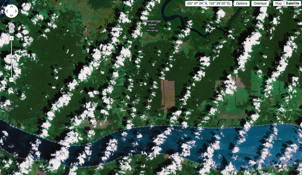
Landsat-based image of Tebingtinggi, Riau Province, Sumatra displayed on Google Earth
Related articles
Researchers develop highest-resolution global forest cover dataset to date
(05/17/2013) Researchers at the University of Maryland have developed a 30-meter resolution forest cover data set that could boost efforts to track deforestation and forest degradation.
Google Time-lapse offers view of Earth over 3 decades

(05/10/2013) Google has released a series of time-lapse images showing global change between 1984 and 2012. The images are sourced from NASA’s Landsat mission, a series of Earth-observation satellites that have orbited the planet since 1972, providing scientists, policymakers, and the general public with a wealth of data and imagery used for a wide range of applications.
Entire planet will soon have rapid deforestation detection system
(04/09/2013) World Resources Institute (WRI) today previewed a long-awaited tool that could revolutionize global forest monitoring, reports the UN Forum on Forests, which is meeting this week in Istanbul, Turkey.
Breakthrough technology enables 3D mapping of rainforests, tree by tree
(10/24/2011) High above the Amazon rainforest in Peru, a team of scientists and technicians is conducting an ambitious experiment: a biological survey of a never-before-explored tract of remote and inaccessible cloud forest. They are doing so using an advanced system that enables them to map the three-dimensional physical structure of the forest as well as its chemical and optical properties. The scientists hope to determine not only what species may lie below but also how the ecosystem is responding to last year’s drought—the worst ever recorded in the Amazon—as well as help Peru develop a better mechanism for monitoring deforestation and degradation.
How satellites are used in conservation

(04/13/2009) In October 2008 scientists with the Royal Botanical Garden at Kew discovered a host of previously unknown species in a remote highland forest in Mozambique. The find was no accident: three years earlier, conservationist Julian Bayliss identified the site—Mount Mabu—using Google Earth, a tool that’s rapidly becoming a critical part of conservation efforts around the world. As the discovery in Mozambique suggests, remote sensing is being used for a bewildering array of applications, from monitoring sea ice to detecting deforestation to tracking wildlife. The number of uses grows as the technology matures and becomes more widely available. Google Earth may represent a critical point, bringing the power of remote sensing to the masses and allowing anyone with an Internet connection to attach data to a geographic representation of Earth.