
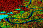
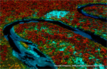
Kaleidoscopic image revealing the biodiversity of the Amazon rainforest. Each color represents different chemical signatures, revealing information about biodiversity and growth rates. Photo courtesy of the Carnegie Airborne Observatory.
Severe drought conditions in 2010 appear to have substantially increased tree mortality in the Western Amazon, a region thought largely immune from the worst effects of changes occurring in other parts of the world’s largest rainforest, reported research presented last week at the fall meeting of the American Geophysical Union (AGU). The findings suggest that the Amazon may face higher-the-expected vulnerability to climate change, potentially undercutting its ability to help mitigate greenhouse gas emissions by absorbing carbon dioxide through faster growth.
The results are based on months of mapping using an advanced airplane-based system that reveals both the physical and chemical structure of a forest at extremely high resolution. The system — known as the Airborne Taxonomic Mapping System (AToMS) — was developed by a team led by Greg Asner of the Carnegie Institution.
According to Nature News, Asner found that the 2010 mega-drought triggered a 4 percent die-off in trees in the most affected area, a sharp increase over the normal rate.
“Limb loss increased as much as four-fold as the team flew into the epicenter of the drought, while the rate of downed trees increased by about 50 percent,” writes Jeff Tollefson. “But trees are big and take time to come down, which means the rate of downed trees will increase in the coming years.”
The findings, which are undergoing peer-review, suggest that the Amazon may be less resilient to climate change than other studies have predicted. Global warming is expected to increase the incidence of drought across much of the Amazon Basin, a prediction already coming to bear — since 2005 the region has experienced the two worst droughts on record.
The preliminary results come shortly after a study published in Nature warned that forests worldwide are vulnerable to elevated tree mortality due to drought stress. The research found that 70 percent of the tree species sampled are particularly vulnerable to reduction in water availability.

Two views of tropical forest canopy in Madre de Dios, Peru from the CAO. The lower kaleidoscopic image, taken in the Manu Biosphere Reserve, reveals biodiversity signals that are missed with the naked eye. Photos courtesy of the Carnegie Airborne Observatory.
Carnegie’s system uses powerful optical, chemical, and laser sensors to create high-resolution, three-dimensional maps of vegetation structure and plant communities. AToMS can capture detailed images of individual trees at a rate of 500,000 or more per minute.
RELATED STUDIES
- Asner, G.P., et al. High-resolution Mapping of Forest Carbon Stocks in the Colombian Amazon. Biogeosciences Discuss., 9, 2445-2479, 2012
- Mascaro, J. at al. Evaluating uncertainty in mapping forest carbon with airborne LiDAR. Remote Sensing of Environment (2011), doi:10.1016/j.rse.2011.07.019
- Asner, G.P., et al. (2011). A universal airborne LiDAR approach for tropical forest carbon mapping. Oecologia DOI 10.1007/s00442-011-2165-z
Related articles
165,000 sq km of Colombian rainforest mapped in stunning detail using lasers, satellites
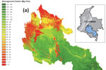
(07/25/2012) Scientists have created high-resolution carbon maps for 165,000 square kilometers (64,000 square miles) of forest across roughly 40 percent of the Colombian Amazon, greatly boosting the ability of the South American nation to measure emissions from deforestation and forest degradation, reports the Carnegie Institution for Science at Stanford University, which led the effort.
Laser-based forest mapping as accurate for carbon as on-the-ground plot sampling
(11/02/2011) Two new research papers show that an advanced laser-based system for forest monitoring is at least as accurate as traditional plot-based assessments when it comes to measuring carbon in tropical forests.
Breakthrough technology enables 3D mapping of rainforests, tree by tree
(10/24/2011) High above the Amazon rainforest in Peru, a team of scientists and technicians is conducting an ambitious experiment: a biological survey of a never-before-explored tract of remote and inaccessible cloud forest. They are doing so using an advanced system that enables them to map the three-dimensional physical structure of the forest as well as its chemical and optical properties. The scientists hope to determine not only what species may lie below but also how the ecosystem is responding to last year’s drought—the worst ever recorded in the Amazon—as well as help Peru develop a better mechanism for monitoring deforestation and degradation.
New technology enables scientists to map rainforest biodiversity by airplane
(06/02/2011) A new airplane-based remote-sensing and analysis system will enable scientists to catalog tree species as they create three-dimensional maps of tropical forests. Unveiled today at the Hiller Aviation Museum in San Carlos, California by Greg Asner of the Carnegie Institution’s Department of Global Ecology, the newest version of the Carnegie Airborne Observatory (CAO) will offer powerful insights into the composition and biology of tropical forests.