Over 13 percent of old growth forests in Pacific Northwest lost to logging in just over a decade, the vast majority on non-federal lands.
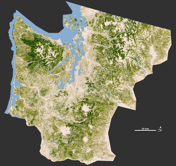
NASA map shows forest cover in Washington and parts of Oregon. The greener an area the more carbon the forest stores. Photo by: NASA.
New satellite and space radar images by NASA shows the decline of forests in the Pacific Northwest, specifically in Washington and Oregon. Lost to development, agriculture, and large-scale logging, the maps apart of the National Biomass and Carbon Dataset (NBCD) show the patchy, fragmented nature of the forests in the two U.S. states (to download large image click here).
“Resource managers need to see forests down to the disturbance resolution—the scale at which parking lots or developments or farms are carved out,” says Josef Kellndorfer, an ecologist at the Woods Hole Research Center (WHRC), in a press release. Kellndorfer heads the NBCD, a U.S. effort to map out the nation’s forests and to estimate the amount of carbon they store.
In the region, including California, the U.S. government owns just under 50 percent of forests and 67 percent of old-growth forests, the most carbon rich and biodiverse of forests. From the 1994-2007 around 1.9 percent of old growth forests were lost on federal lands. However, less than 0.5 percent of old-growth forests on federal lands were lost due to logging (around 12,990 hectares), while the rest (around 80,937 acres) were lost to wildfires.
Logging had a much bigger impact on non-federal lands: 198,700 hectares of old growth forests (about 13 percent) were lost to logging on these lands from 2003-2006, about half the size of Rhode Island.
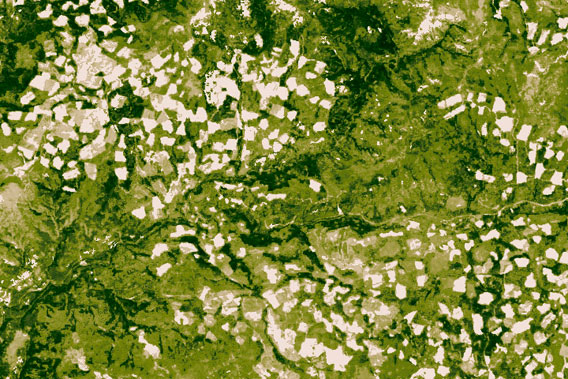
Detail shows the fragmented forests of the Pacific Northwest. Photo by: NASA.
Related articles
NASA map reveals the heights of the world’s forests
(02/20/2012) The height of a forest is important in a number of different ways. First the taller a forest, the more likely there are important niche habitats in the canopy providing homes to unique species. In addition, a forests’ height says something about its ability to sequester carbon: the taller a forest the more carbon it can hold. Now a team of researchers, led by NASA, has created the world’s first global map showing the height of the world’s forests (click here for interactive map), publishing their findings in the Journal of Geophysical Research.
Green groups: government moving too slowly on protecting Canada’s Great Bear rainforest
(02/08/2012) Three environmental groups have submitted a letter to British Columbia Premier, Christy Clark, to ask the government to speed up the process of implementing the Great Bear Rainforest Agreement, which is meant to ensure 70 percent of old-growth forest is maintained.
Economic slowdown leads to the pulping of Latvia’s forests
(01/23/2012) The economic crisis has pushed many nations to scramble for revenue and jobs in tight times, and the small Eastern European nation of Latvia is no different. Facing tough circumstances, the country turned to its most important and abundant natural resource: forests. The Latvian government accepted a new plan for the nation’s forests, which has resulted in logging at rates many scientists say are clearly unsustainable. In addition, researchers contend that the on-the-ground practices of state-owned timber giant, Latvijas Valsts meži (LVM), are hurting wildlife and destroying rare ecosystems.