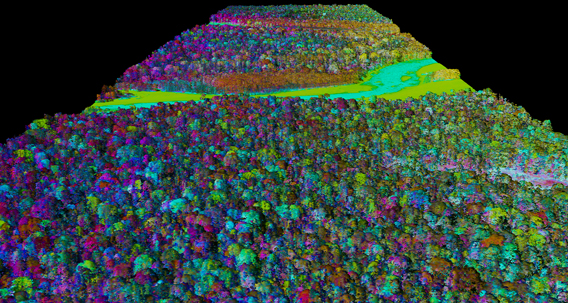
 Upper: Sectional view of AToMS LiDAR 3D image of the lowland Amazon rainforest canopy. Photo courtesy of the Carnegie Airborne Observatory. |
Two new research papers show that an advanced laser-based system for forest monitoring is at least as accurate as traditional plot-based assessments when it comes to measuring carbon in tropical forests.
The first paper, published in Remote Sensing of Environment by researchers from the Department of Global Ecology at Carnegie Institution for Science and the Smithsonian Tropical Research Institute (STRI), compared plot data for Barro Colorado Island, Panama — the most intensively studied tract of tropical forest on Earth — with carbon data derived from overhead flights using the Carnegie Airborne Observatory’s (CAO) LiDAR system. It found that “lidar-based uncertainties of aboveground carbon stocks are indistinguishable from errors obtained when doing the most detailed plot-based estimates.”
The second paper, published in Oecologia by researchers from Carnegie, STRI, and other institutions, laid out a universal equation for determining forest carbon stock values from LiDAR data. The equation — based on sampling of forests in Panama, Peru, Madagascar, and Hawaii — is adjusted for a forest region based two variables: basal area and wood density information, allowing researchers to “radically decrease” the time needed to calibrate airborne LiDAR data.
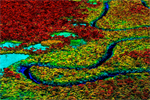
 Higher biomass (red) to lower biomass (yellow) forests, and deforestation patches in blue. Photo courtesy of the Carnegie Airborne Observatory. |
The research has important implications for mapping global forest carbon stocks, according to Greg Asner, the Carnegie Institution scientist who leads CAO.
“This new approach opens doors for really accurately monitoring how much carbon is stored in tropical forests, which has been one of the key challenges in developing international strategies to mitigate climate change,” he told mongabay.com.
“We hope these contributions will continue to support carbon-climate policy and forest protection initiatives through high-resolution monitoring, while also opening new doors for scientists and resource managers to study carbon landscapes in tropical regions.”
Asner’s team is using LiDAR and other sensors to conduct high resolution carbon stock and biodiversity assessment across tropical forests in Latin America.
CITATIONS
- Joseph Mascaro, Matteo Detto, Gregory P. Asner, Helene C. Muller-Landau. Evaluating uncertainty in mapping forest carbon with airborne LiDAR. Remote Sensing of Environment (2011), doi:10.1016/j.rse.2011.07.019
- Gregory P. Asner, Joseph Mascaro, Helene C. Muller-Landau, Ghislain Vieilledent, Romuald Vaudry, Maminiaina Rasamoelina, Jefferson S. Hall, Michiel van Breugel (2011). A universal airborne LiDAR approach for tropical forest carbon mapping. Oecologia DOI 10.1007/s00442-011-2165-z
Related articles
Breakthrough technology enables 3D mapping of rainforests, tree by tree
(10/24/2011) High above the Amazon rainforest in Peru, a team of scientists and technicians is conducting an ambitious experiment: a biological survey of a never-before-explored tract of remote and inaccessible cloud forest. They are doing so using an advanced system that enables them to map the three-dimensional physical structure of the forest as well as its chemical and optical properties. The scientists hope to determine not only what species may lie below but also how the ecosystem is responding to last year’s drought—the worst ever recorded in the Amazon—as well as help Peru develop a better mechanism for monitoring deforestation and degradation.