This is an expanded version of an article that ran on Yale e360 on October 3, 2011: A Revolutionary Technology is Unlocking Secrets of the Forest.
High above the Amazon rainforest in Peru, a team of scientists and technicians is conducting an ambitious experiment: a biological survey of a never-before-explored tract of remote and inaccessible cloud forest. They are doing so using an advanced system that enables them to map the three-dimensional physical structure of the forest as well as its chemical and optical properties. The scientists hope to determine not only what species may lie below but also how the ecosystem is responding to last year’s drought—the worst ever recorded in the Amazon—as well as help Peru develop a better mechanism for monitoring deforestation and degradation.
The system—conceived by Greg Asner, a scientist at the Carnegie Institution for Science—has the potential to transform how tropical research is conducted. It could also help alleviate uncertainty about carbon emissions from deforestation and different forms of forest management, both of which are critical to REDD, a U.N. program designed to compensate tropical countries for reducing deforestation and forest degradation. Finally, the system may substantially improve understanding of tropical ecosystems.
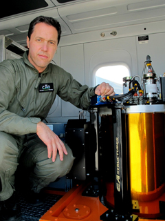 Greg Asner, PI of CAO, beside CAO’s VSWIR Imaging Spectrometer. Photo courtesy of the Carnegie Airborne Observatory. |
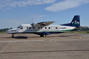
Asner did his undergraduate work as an engineer and subsequently trained in ecology and biogeochemistry. Applying his engineering acumen to biological issues, he developed the original Carnegie Airborne Observatory (CAO) in 2006 to measure key characteristics of tropical forests. The CAO is a specialized aircraft equipped with optical, chemical, and laser sensors, which together form AToMS (the Airborne Taxonomic Mapping System), enabling Asner and his team to create high-resolution, three-dimensional maps of vegetation structure and plant communities.
While satellite forest monitoring systems provide breadth of coverage, CAO offers detail. Whereas a satellite (e.g. MODIS or LandSat) might typically enable mapping in tens of meters to kilometers in resolution, CAO can capture detailed images of individual trees at a rate of 500,000 or more per minute. There are no other aircraft systems with the capabilities of CAO, although Asner is helping the National Science Foundation develop one and is in talks with NASA about equipping a satellite with the system.
“The whole idea was to measure each of the things plant ecologists measure on the ground to evaluate biodiversity,” said Asner, as we flew 7,000 feet over the Amazonian cloud forest about an hour’s flying time from Cuzco. “There was not a single technology that could measure each of the features we needed, so we decided to put together technologies that were close to doing some of those things. Along the way we developed some new technologies.”
 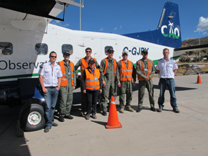 The CAO and the CAO crew. Photo courtesy of the Carnegie Airborne Observatory. |
To understand tropical forest ecology, one of the most basic things scientists need to know about a landscape is the types of habitats available. CAO is equipped with a powerful LiDAR system with a pair of sweeping lasers that send 400,000 pulses per second toward the ground below. These blast through canopy vegetation, reach the forest floor, and return a wealth of information about the forest’s structure. Depending on the aircraft’s altitude, sensors can map the forest at resolutions ranging from ten centimeters to one meter,fine enough to “see” understory shrubs and epiphytes in tree crowns. LiDAR is also very good for measuring above-ground biomass, or the amount of carbon stored in a forest’s vegetation, as well as for hydrology—it can pick up surface elevations to identify watersheds and waterways.
These capabilities make LiDAR a powerful tool for mapping the habitat created by the canopy in tropical forests. The sensor has already been used by primatologists in the Amazon to see how trees branch and understand why primates select certain habitats.
But the LiDAR is only one of CAO’s strengths. To truly understand an ecosystem, scientists need to know more about its characteristics, including aspects that can’t be been by the naked eye. This is where CAO really sets itself apart—its VSWIR Imaging Spectrometer can pick up the chemical and spectral (light-reflecting) properties of individual plants thousands of feet below.
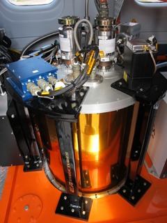 CAO’s keystone sensor – the Very High Fidelity VSWIR Spectrometer. Photo courtesy of the Carnegie Airborne Observatory. |
This sensor—built by engineers at NASA’s Jet Propulsion Laboratory—is the first of its kind. The spectrometer can detect dozens of signals such as photosynthetic pigment concentrations, water content of leaves, defense compounds like phenols, structural compounds such as lignin and cellulose, as well as phosphorous and other micronutrients. These signals can build signatures to distinguish individual plant species as well as other measures of forest condition. The result is a system that can map the chemical and spectral attributes of a forest that may have more than 200 species of tree in 50 hectares.
“When leaves interact with sunlight, the compounds bend, stretch, and vibrate at different patterns and rates. These different rates lead to different scattering of light,” said Asner. “The spectrometer picks up on this and we’ve been able to deduce chemicals from these signatures.”
“This is the gateway to understanding the chemistry of the system,” he said. “We can make a map of where trees are growing the fastest. The spectrometer is the breakthrough sensor.”
Robin Martin, a plant biochemist at Carnegie who helped develop CAO and is also Asner’s wife, says the chemical detection “tells us about the health and function of the forest.”
“The CAO allows us to combine the chemical measurements with forest structural information to convert those chemical signals into biodiversity estimates.”
The VSWIR spectrometer is augmented by the third sensor, which is also a spectrometer, albeit one with a zoom lens, allowing researchers to read the growth chemistry of the forest with high spatial resolution.
“A lot of times species are closely intermingled in the canopy,” says Asner. “The big gold sensor [the VSWIR] can see tree crowns, while the zoom lens lets us see within the tree crown, picking up vines and epiphytes.”
The aircraft that carries the system allows Asner’s team to map very large areas, sometimes more than 120,000 acres a day. In 2009, using an older, less sophisticated version of the system, Asner mapped 4.3 million hectares of Peru’s Madre de Dios Department. Now he is working on a bigger scale: nearly the entire Peruvian Amazon. After this, he goes to Colombia and Panama. Asner has also run the system in Madagascar.
But for CAO to assess biodiversity accurately, Asner’s team first has to do the groundwork. In the Amazon, Asner and his team built up a catalog of the chemical and spectral properties of nearly 5,000 plant species collected during extensive field work.
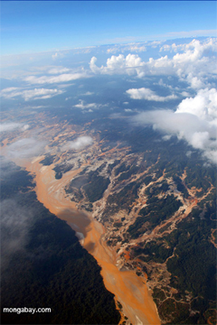
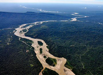
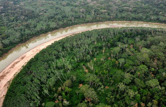 A bend in the Rio Manu in western Madre de Dios. Photos courtesy of the Carnegie Airborne Observatory. |
Extending tree-climbing to the skies
Traditional approaches to mapping forests and conducting biological surveys involve getting boots on the ground. But the terrain limits exploration to relatively tiny regions where there are roads, navigable waterways, or in some cases, helipads. For that reason, large areas of the Amazon and other rainforests, including the cloud forest below us in Peru, have never been explored by scientists. The vast majority of what is known about sub-montane Amazon forests comes from a single mountain valley outside of Cuzco, Peru.
Asner’s team still does work on the ground, but once his tree-climbing botanists have assessed an area, they use technology to apply what they have learned to more inaccessible regions. CAO allows Asner’s team to greatly leverage their field work.
“We have the best team of tree-climbers in the world,” said Asner. “They can climb 75 trees a day, conducting full sampling.”
As the climbers collect samples of canopy trees, the data are fed into CAO’s library of information on individual plant species, which supports the aerial surveying.
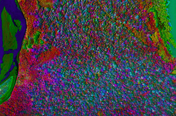
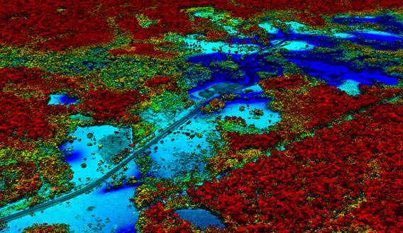 3D forest mapping along the Interoceanic Highway, a road that was just upgraded to facilitate transport of commodities from the Amazon to Pacific coast ports. Asner’s research has shown that improvement of the “Transoceanica”, as it is sometimes known, has triggered a sharp increase in deforestation in surrounding areas. Images courtesy of the Carnegie Airborne Observatory. |
Improving the accuracy of carbon accounting for REDD
The most obvious and immediate application of the work is measuring carbon in forests to support REDD programs. CAO offers a much higher resolution carbon mapping capability than carbon maps originally used by the U.N. for its IPCC Tier II carbon maps. For example, where an IPCC carbon map shows a sea of green, Asner’s map is a riot of color, reflecting different carbon values, which are a function of soils and history. The high resolution enables Asner to tease out subtle human impacts like selective logging. He can also measure compounds that reveal tree growth.
“The forest there has Pleistocene soils and stores 20% less carbon,” he says, pointing to a tract of forest. “The only way to know this is by the sensor. Visually, it all looks the same from above.”
 The Río Huaypetue gold mine in Peru as seen from above (Photo by Rhett Butler). |
The data can be used to help calibrate satellite-based carbon detection and monitoring systems. Asner’s lab has already developed one of the mostly widely used platforms, CLASlite, which uses data from NASA Landsat satellites.
CAO’s work is helping the Ministry of the Environment in Peru (MINAM) advance its ability to monitor deforestation and forest degradation. Peru, like many tropical nations, has ambitious hopes that REDD could offer a new source of revenue that doesn’t degrade its natural resource base, thereby safeguarding important ecological services, including watershed protection. Vegetation data from CAO will feed into MINAM’s satellite monitoring system to help improve it.
“The expected result of CAO’s campaign in Peru is to improve our protocol for monitoring deforestation and forest degradation,” said Doris Rueda of MINAM. “Updated information will help estimate carbon stocks in the regions and to identify areas affected by illegal activities (mining and coca, mostly).”
“CAO is also providing technical and scientific support and associated training of our specialists for proper implementation of the technology.”
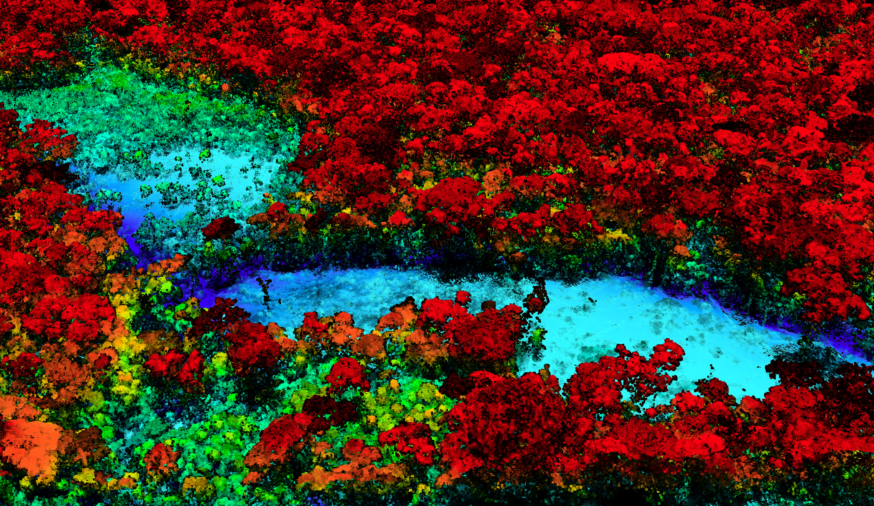
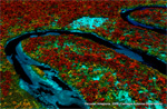
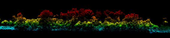 Upper: Sectional view of AToMS LiDAR 3D image of the lowland Amazon rainforest canopy. Lower: AToMS mapping of biodiversity – constant red coloring indicates lower diversity secondary vegetation, and multi-color canopies indicate highest diversity portions of the forest. From northern Madre de Dios. Photos courtesy of the Carnegie Airborne Observatory. |
Mapping biodiversity
The area that is of greatest interest to Asner, however, is scientific exploration.
“We’re looking at biodiversity in regions that have never been put down on the science map.”
Flying over the rugged region where the Amazon meets the Andes, it is easy to see why the area has never been assessed for its biodiversity — or for anything else. The terrain is rough. There are formidable mountain ranges with sheer cliffs, and rivers that boil with rapids. Clouds cover the area most of the time, although today CAO appears to have caught a break — the skies are clear. (Later I learn that this is not luck, but the product of careful planning based on satellite tracking of clouds).
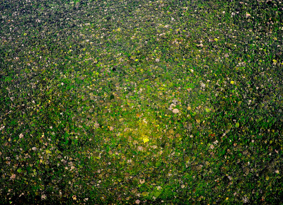
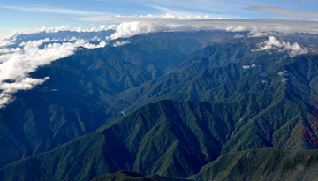  Upper: Montane tropical forests of Pasco; Lower: Sub-montane forests in northwestern Made de Dios. Pictures courtesy of the Carnegie Airborne Observatory. |
The pilots line up the plane with points on the flight plan. The process is very precise—the team uses a powerful GPS system to correct any inaccuracies of the on-board system. This particular transect is on the short side—a few miles. The flight path must remain completely clear of clouds in order for the sensors to pick up spectral and chemical readings. We’re flying a gradient down a forested slope. The pilots must maintain a constant altitude of 7,000 feet above the ground.
“We are flying over 500,000 tree crowns a minute now,” Asner says once the sensors are turned on. “When we reach the lower elevation end of the transect, we will be flying over 250,000 tree crowns a minute because the trees are larger in the lowlands.”
Flying in a plane is much easier than battling heat, humidity, and the forest on the ground. But this work isn’t possible without doing ground study first. Asner’s plans to expand surveys to places outside the Amazon will require more field work. To speed this process, Asner has partnered with several scientific groups like the Smithsonian Tropical Research Institute (STRI), which has field sites in dozens of countries, and the Missouri Botanical Garden, which has some of the world’s most capable botanists.
Pete Lowry, head of the Missouri Botanical Garden’s Africa and Madagascar Department who worked with Asner and his team in Madagascar in 2010, says CAO has great potential provided it is accompanied by careful work on the ground.
“The botanical diversity at the two sites where we worked was very well-documented,” he said. “However, applying this method in a new area is going to require careful ground-truthing.”
Lowry believes CAO could be especially useful for looking at total tree species diversity and dominance, and for prioritizing areas for further research.
“This is really cool, cutting-edge technology, but we have to remain cognizant of the fact that while the methodology is being perfected it has to be fully rooted in high-level knowledge of botanical diversity on the ground.”
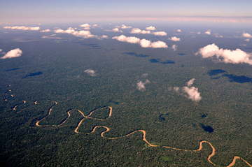  Upper: Meandering lowland river (Picture courtesy of the Carnegie Airborne Observatory); Lower: Shadow of the CAO over the Amazon (Photo by Rhett Butler). |
Adrian Forsyth, an ecologist who founded and heads the Amazon Conservation Association, which works in Peru, says that CAO could be particularly useful in conducting preliminary, rapid biological assessments of unknown areas.
“There are only a handful of field biologists who are capable of doing good on-the-ground field botany in the remote areas of the Amazon, the Congo, and New Guinea, so demand far outstrips supply,” he said. “Any tool that gives you a first order approximation of the magnitude of biodiversity, without the high costs of bringing in a large expedition team, is going to be a valuable tool. This is especially true in rugged terrain, like the mountains of New Guinea and Peru, where there is not only lack of road access but river access.”
Once an area of particular interest is identified, scientists could then decide whether it is worth the effort and expense to send in an expedition or leave it “unexplored” for future generations. With CAO, scientists can at least get some clues about what remote forests may hold, and whether there are pressing threats like selective logging and road development.
“With its expanded capabilities the new CAO helps us understand the chemistry, structure, and biodiversity of the forest below,” said Asner. “It can also provide indications of forest health—including evidence of water stress—as well as potential threats from human activity.”
Greg Asner talks with Mongabay.com’s Rhett Butler about the new CAO
Related articles
New technology enables scientists to map rainforest biodiversity by airplane
(06/02/2011) A new airplane-based remote-sensing and analysis system will enable scientists to catalog tree species as they create three-dimensional maps of tropical forests. Unveiled today at the Hiller Aviation Museum in San Carlos, California by Greg Asner of the Carnegie Institution’s Department of Global Ecology, the newest version of the Carnegie Airborne Observatory (CAO) will offer powerful insights into the composition and biology of tropical forests.
80% of rainforests could adversely impacted by logging, deforestation, climate change by 2100
(08/05/2010) The world’s tropical forests may suffer large-scale degradation and deforestation by the end of the century if current logging and climate change trends persist, finds a new analysis published in Conservation Letters.
Google Earth boosts deforestation monitoring capabilities
(02/07/2010) Google has taken a step towards ramping up the deforestation monitoring capabilities the Google Earth Engine by contracting Massachusetts-based Clark Labs to develop an online version of its Land Change Modeler application.
Selective logging occurs in 28 percent of world’s rainforests
(01/13/2009) New satellite research presented for the first time at a symposium entitled “Will the rainforests survive?” showed that selective logging is impacting over a quarter of the world’s rainforests. Gregory Asner from the Carnegie Institution presented the “first true global estimate of selective logging” which showed that 5.5 million square kilometers of the rainforest has already seen selective logging or is slated to be logged in the near future.
Google Earth to monitor deforestation
(12/10/2009) It what could be a critical development in helping tropical countries monitor deforestation, Google has unveiled a partnership with scientists using advanced remote sensing technology to rapidly analyze and map forest cover in extremely high resolution. The effort could help countries detect deforestation shortly after it occurs making it easier to prevent further forest clearing.
How satellites are used in conservation

(04/13/2009) In October 2008 scientists with the Royal Botanical Garden at Kew discovered a host of previously unknown species in a remote highland forest in Mozambique. The find was no accident: three years earlier, conservationist Julian Bayliss identified the site—Mount Mabu—using Google Earth, a tool that’s rapidly becoming a critical part of conservation efforts around the world. As the discovery in Mozambique suggests, remote sensing is being used for a bewildering array of applications, from monitoring sea ice to detecting deforestation to tracking wildlife. The number of uses grows as the technology matures and becomes more widely available. Google Earth may represent a critical point, bringing the power of remote sensing to the masses and allowing anyone with an Internet connection to attach data to a geographic representation of Earth.