High rates of deforestation are likely to continue in Pará and Mato Grosso, while federal and especially state conservation units fail to protect Brazil’s rainforest.
A new report from Imazon, a Brazilian NGO that tracks deforestation, models the risk of deforestation in the Brazilian Amazon for the coming year. The Imazon team identified four levels of deforestation risk: low, moderate, high, and critical. The critical level is reserved for areas of greater than 100 sq km (38 sq mi) with a risk of deforestation greater than one percent. The Vale Fund and the Climate and Land Use Alliance supported Imazon’s research.
Imazon’s SAD (Alert System of Deforestation) system, which uses a complex algorithm to predict deforestation with a 95 percent level of statistical confidence, estimates 2,721 sq km (1,050 sq mi) of rainforest will be deforested between August 2011 and July 2012. Forest in the states of Pará and Mato Grosso are at greatest risk of clearing, and at a critical level: 72 percent of deforestation in the next year is expected in Pará, while Mato Grosso can expect 11 percent of forecast deforestation within its territory.
Roads into the Amazon allow access to forests and promote deforestation, and forest along the BR-230 highway (Rodovia Transamazônia) and BR-163 (Rodovia Cuiabá-Santarém) have the highest probability of deforestation, finds Imazon. Other high-risk areas include northeastern and central Pará, northern and central Mato Grosso, and forests in Acre and Rondônia. The top three municipalities at risk of deforestation are in Pará.
Sixty-five percent of predicted deforestation is expected on private land, unclaimed properties, and land with disputed ownership. Twenty-five percent of deforestation may occur in agrarian reform settlements, areas where the rural poor have gained access to land. A scant three percent of deforestation is predicted on indigenous lands, while a troubling eight percent of rainforest at risk of deforestation lies within Brazil’s conservation units (similar to national forests and parks in the United States).
Agrarian reform settlements will see the highest concentration of deforestation in Pará. Farmers may clear forest illegally to augment their land holdings or for timber. As agrarian reform communities rarely have effective law enforcement or government presence, it is also not uncommon for outsiders to enter the area to harvest timber. Imazon’s model predicts some settlements will lose more than 10 percent of their remaining forest reserves.
Predicted deforestation in protected areas is particularly worrisome. While Imazon finds indigenous territories are at low risk for deforestation, risk is concentrated in only a handful of reservations. Sixty nine percent of deforestation expected in government conservation units may occur in state-run conservation units (UCEs), casting doubt on their effectiveness in comparison to federal conservation units (UCFs). While only three percent of deforestation predicted may be within UCFs, 72 percent of this forecast deforestation is concentrated in only 10 conservation units.
CITATION: Márcio Sales, Carlos Souza Jr., and Sanae Hayashi. Risk of Deforestation. Edition 2, August 2011-July 2012.
Related articles
Deforestation in the Brazilian Amazon up moderately over last year
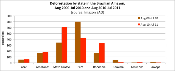
(08/24/2011) Deforestation in the Amazon jumped sharply in some Brazilian states since last year, according to data released in recent weeks by Imazon, a Brazilian NGO that tracks deforestation. Overall deforestation rose 15 percent to 1,532 km2 in the August 2010 through June 2011 period relative to the same months a year earlier, reports Imazon.
Satellite data shows slight increase in Amazon deforestation over June last year
(08/03/2011) Deforestation in the Brazilian Amazon rose 17 percent in June compared to the same period a year earlier, reports Brazil’s National Institute for Space Research (INPE).
Brazilian government: Amazon deforestation rising
(06/30/2011) Satellite data released today by the Brazilian government confirmed a rise in Amazon deforestation over this time last year.
Deforestation in Brazil’s Amazon continues to rise; clearing highest near Belo Monte dam site
(06/17/2011) Deforestation in the Brazilian Amazon continued to rise as Brazil’s Congress weighed a bill that would weaken the country’s Forest Code, according to new analysis by Imazon.