Researchers have devised a model to anticipate drought and forest fires in the Amazon rainforest.
The research, which used precipitation records dating back to 1970 and hotspots tracked by the Moderate Resolution Imaging Spectroradiometer (MODIS) aboard NASA satellites, finds a strong correlation between sea surface temperatures in the tropical North Atlantic and subsequent drought in the western Amazon. Drought in the Amazon is increasingly associated with forest fires due to land-clearing fires set by agricultural developers and cattle ranchers.
The researchers, led by Katia Fernandes of Columbia University, conclude that their model could be used to forecast drought up the three months in advance, giving authorities a window to alert ranchers and farmers about the increased risk of using fire to clear land during the dry season, which typically runs from July-September. Coupled with its existing satellite-based deforestation monitoring capabilities, the warning system could prove useful to Brazil as it aims to reduce deforestation rates under its national climate action plan.
The study, which is published in Geophysical Research Letters, comes on the heels of another paper, published in the same issue, that reports an increase in droughts in the Amazon.
That research — led by Jose Marengo of Brazil’s National Institute for Space Research (INPE) — identifies the 2005 and 2010 droughts in the Amazon as the worst on record. It finds that since the mid-1970s droughts have increased in the Amazon region, while the length of the typical dry season has expanded. The study says droughts are “aggravated” when there was low rainfall in the previous wet season.
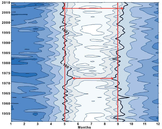 Representation (Hovmoller diagram) of precipitation in the southern Amazon from 1951 to 2010. The shade reflects the amount of rainfall, with the 100 mm (2.5-inches) level marked in bold as an indicator of dry months. You can see that the length of the dry season has increased over time. Image courtesy of Marengo et al (2011). |
The 2010 drought affected some 3 million square kilometers of forest, nearly 60 percent more than the 1.9 million square kilometers affected during the 2005 drought. Both events triggered severe drops in water levels for Amazon tributaries, stranding communities and stalling river transportation. Fires and associated ‘haze’ increased markedly during both droughts.
Scientists have warned for years that climate change could turn much of the Amazon into a tinderbox. Other research suggests that by mid-century, much of the Amazon could be at risk of die-off due to climate change-induced drought, the effects of which are worsened by deforestation, forest degradation, and fragmentation.
Citations:
Related articles