Google released satellite images revealing the devastation caused by the March 11 tsunami in Japan.
The satellite images, which are available on Google Earth and Google Maps, show dramatically changed landscapes, including flooded cities and agricultural areas, buildings swept away by the tsunami surge, and smoke rising from ruined homes.
Google says it is providing the high-resolution imagery to emergency crews and organizations working on the ground
“We’re working to provide this data directly to response organizations on the ground to aid their efforts,” wrote Ryan Falor, of the Google Crisis Response team, on the official Google Blog. “We hope this new updated satellite imagery is valuable for them as well as everyone else following this situation to help illustrate the extent of the damage.”
The March 11 earthquake that triggered the tsunami was recently upgraded to a 9.0, the strongest quake to hit Japan in modern times. It was the fifth strongest quake since record-keeping began in the late nineteenth century.
The tsunami struck the eastern coast of Honshu island, moving it nearly 8 feet east. It caused heavy damage to infrastructure, including nuclear reactors, three of which partly melted down. More than 10,000 are feared dead.
Google released satellite imagery from several areas, towns, and cities, including Central Ishinomaki, Fukushima, the Oshika Peninsula and Iigoham, Iwaki-Ueda, Kesennuma, Minamisanriku, Minamisoma-Kashima, Minamisoma, Odohama, Ofunato Rikuzentakata, Rikuzentakata, Sendai airport, Sendai, Watari / Lake Torinoumi, Watari, Yagawahama and the Oshika Peninsula, and Yamamoto.
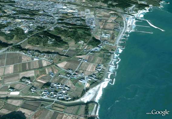
Fukushima Tomioka 2004. Satellite picture courtesy of Google Earth / GeoEye.
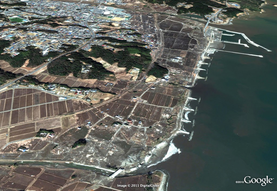
Fukushima Tomioka after tsunami damage. Satellite picture courtesy of Google Earth / GeoEye.
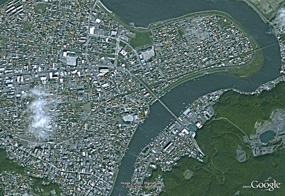
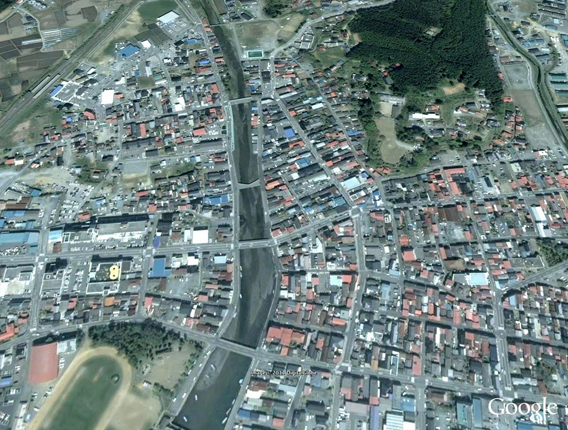
Central Ishinomaki 2003. Satellite picture courtesy of Google Earth / GeoEye.
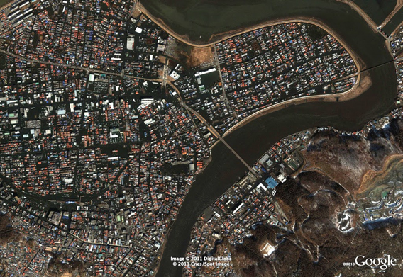
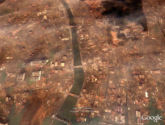
Central Ishinomaki GeoEye after tsunami damage. Satellite picture courtesy of Google Earth / GeoEye.
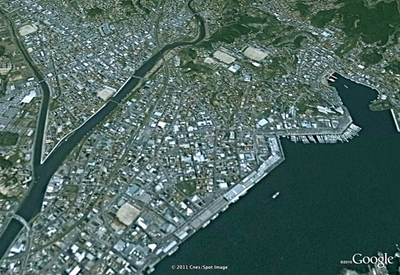
Kesennuma 2002. Satellite picture courtesy of Google Earth / GeoEye.
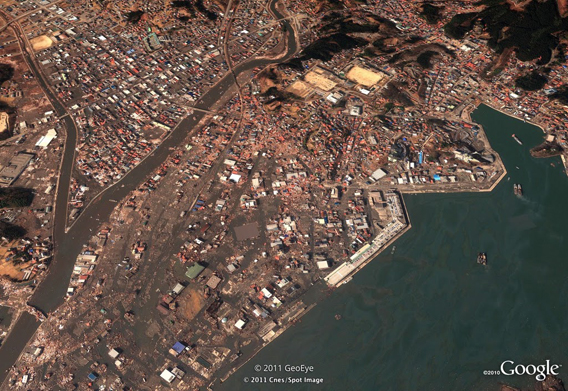
Kesennuma after tsunami damage. Satellite picture courtesy of Google Earth / GeoEye.
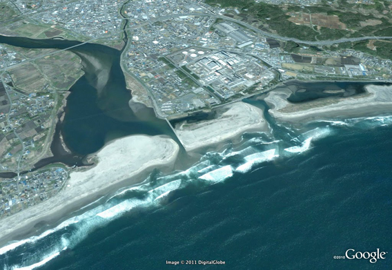
Iwaki Ueda 2005. Satellite picture courtesy of Google Earth / GeoEye.
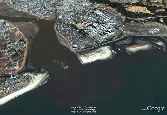
Iwaki Ueda after tsunami damage. Satellite picture courtesy of Google Earth / GeoEye.
Minamisanriku detail 2002. Satellite picture courtesy of Google Earth / GeoEye.
Minamisanriku detail tsunami damage. Satellite picture courtesy of Google Earth / GeoEye.
next
Related articles
Japan’s earthquake disaster may boost rainforest logging in Borneo
(03/13/2011) Malaysian loggers say Japan’s recovery from last week’s devastating earthquake and tsunami will boost demand for rainforest timber, reports the Borneo Post.
Is Japan’s tsunami linked to climate change?
(03/11/2011) Could the earthquake that triggered Japan’s devastating tsunami be linked to climate change? The short answer is probably not, but recent research suggests that changing climate has the potential to influence earthquakes in some parts of the world