Deforestation in the Brazilian Amazon is roughly flat for the 7 months ended February 28 relative to the same period last year, reports Imazon, a Brazil-based NGO.
Using its the near real-term alert component of its satellite-based deforestation tracking system, Imazon found accumulated deforestation between August 2010 to February 2011 amounted to roughly 925 square kilometers, virtually identical to the 924 square kilometers detected between August 2009-February 2010. But degradation — forest that has been selectively logged, affected by fire, or otherwise damaged — increased by more than 300 percent to 3,836 square kilometers over the year-earlier period.
But Imazon is cautious to draw conclusions from the data. Intra-year estimates for deforestation in the Brazilian Amazon are notoriously difficult to assess due to cloud cover, distinctions between degradation and deforestation, seasonal variations, and other variables. Figures are usually reconciled each August using a different methodology that relies on higher resolution imagery. INPE, Brazil’s space research agency, generally publishes these results towards the end of the year.
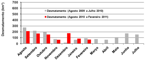
Deforestation from Aug 2010-Feb 2011 and Aud 2009-Feb 2010
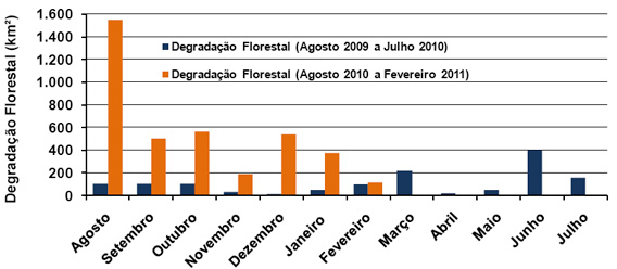
Forest degradation from Aug 2010-Feb 2011 and Aud 2009-Feb 2010
Most analysts had been expecting a rise in Amazon deforestation due to rising commodity prices, although a strengthening real has offset much of the price appreciation. Another factor that could be impacting forest clearing in Brazil is the commitment among major players in the cattle industry to stop buying from ranches involved in deforestation. The restriction was brought about by a Greenpeace campaign and threats by state prosecutors in June 2009.
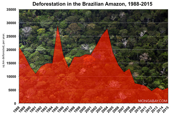
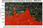
Under its national climate action plan, Brazil has set an ambitious target to reduce its deforestation rate. Deforestation in the Brazilian Amazon last year was more than 75 percent lower than its last peak in 2004.
Related articles
Monitoring deforestation: an interview with Gilberto Camara, head of Brazil’s space agency INPE
(02/08/2011) Perhaps unsurprisingly, the world’s best deforestation tracking system is found in the country with the most rainforest: Brazil. Following international outcry over immense forest loss in the 1980s, Brazil in the 1990s set in motion a plan to develop a satellite-based system for tracking changes in forest cover. In 2003 Brazil made the system available to the world via its web site, providing transparency on an issue that was until then seen as a badge of shame by some. Since then Brazil has become recognized as the standard-bearer for deforestation tracking and reporting—no other country offers the kind of data Brazil provides. Space engineer Gilberto Camara has overseen much of INPE’s earth sensing work and during his watch, INPE has released several new exciting capabilities.
Brazil’s Amazon deforestation rate falls to lowest on record
(12/01/2010) Deforestation in the Brazilian Amazon fell to the lowest rate on record, putting Brazil well on track to meet its targets for reducing rainforest destruction. Analysis of satellite imagery by Brazil’s National Institute for Space Research (INPE) shows that 6,450 square kilometers of rainforest were cleared in the Amazon in the 12 months ended July 31, 2010, a 14 percent drop from the year earlier period.
How satellites are used in conservation

(04/13/2009) In October 2008 scientists with the Royal Botanical Garden at Kew discovered a host of previously unknown species in a remote highland forest in Mozambique. The find was no accident: three years earlier, conservationist Julian Bayliss identified the site—Mount Mabu—using Google Earth, a tool that’s rapidly becoming a critical part of conservation efforts around the world. As the discovery in Mozambique suggests, remote sensing is being used for a bewildering array of applications, from monitoring sea ice to detecting deforestation to tracking wildlife. The number of uses grows as the technology matures and becomes more widely available. Google Earth may represent a critical point, bringing the power of remote sensing to the masses and allowing anyone with an Internet connection to attach data to a geographic representation of Earth.