In August NASA and the US Geological Survey released the first-ever satellite analysis of the world’s mangrove ecosystems. What they found was dire: mangroves covered 12.3% less area than previously estimated. Now, NASA has released images of the world’s mangrove ecosystems (see below), which currently cover 137,760 square kilometers. Yet this number keeps shrinking: mangroves are vanishing rapidly due to rising sea levels, deforestation for coastal developments, agriculture and aquaculture.
Among the world’s most important ecosystems, mangroves are tropical saline-adapted forests that survive in tropical coastlines. These forests serve as nurseries for a variety marine fish, underpinning global fisheries and providing additional food for coastal communities. In addition, they store massive amounts of carbon and act as buffers against marine erosion. Recent studies have even found that mangroves buffer human populations and property against tropical storms. During the devastating 2004 tsunami in Southeast Asia, regions with mangroves suffered less damage than those without. In all it has been estimated that mangroves provide at least $1.6 billion in ecosystem services annually. Yet despite their importance, less than 7% of the world’s mangroves are under legal protection.
Known as a center for rainforest destruction, Indonesia has also lost most of its mangroves (see second image below). From 1982 to 2000, Indonesia has lost over half of its mangrove forests, falling from 4.2 million hectares to 2 million.
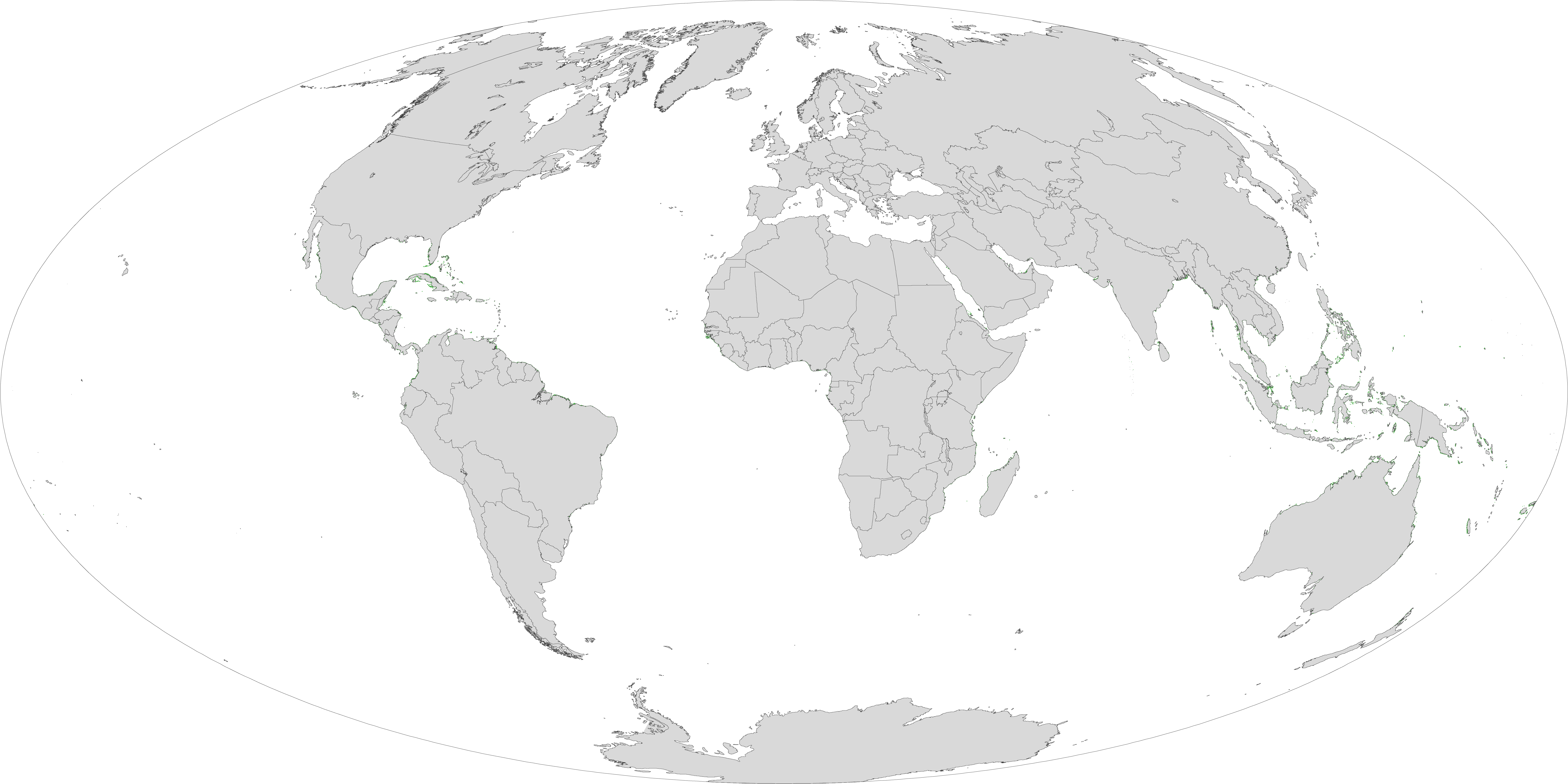
Global extent of mangrove ecosystems. Image courtesy of NASA and the US Geological Society. Click to enlarge.
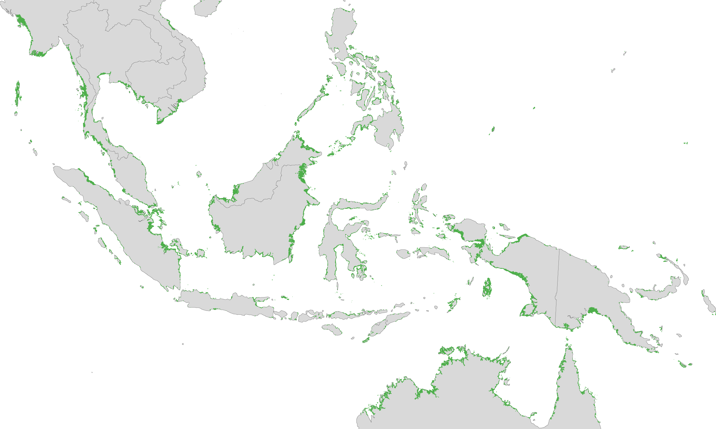
Extent of mangroves in Southeast Asia. Image courtesy of NASA and the US Geological Society. Click to enlarge.
Related articles
Satellites show mangrove forest loss even worse than estimated
(08/19/2010) New satellite data shows that human actions are wiping out mangrove forests even faster than previous bleak estimates. Conducted by the US Geological Survey and NASA, the researchers found that mangroves comprise 12.3 percent less area than previously estimated. In total, satellites reveal that mangrove forests cover approximately 53,290 square miles (137,760 square kilometers). “Our assessment shows, for the first time, the exact extent and distribution of mangrove forests of the world at 30 meters spatial resolution, the highest resolution ever,” said Dr Chandra Giri from USGS.
Slight rise in mangrove forests in Eastern India
(11/29/2010) While mangrove forests are vanishing around the world, the Indian Ministry of Environment and Forests is reporting a slight uptick of mangrove forests along the nation’s eastern coast. According to a report, mangroves expanded from 4,581 square kilometers in 2005 to 4,639 square kilometers in 2007, an increase of 58 square kilometers.
A fifth of the world’s mangroves gone in 30 years
(07/18/2010) A new report by the United Nation Environment Program (UNEP) and the Nature Conservancy has found that mangrove forests are being lost at staggering rates worldwide: since 1980 one fifth of the world’s mangroves have been felled.