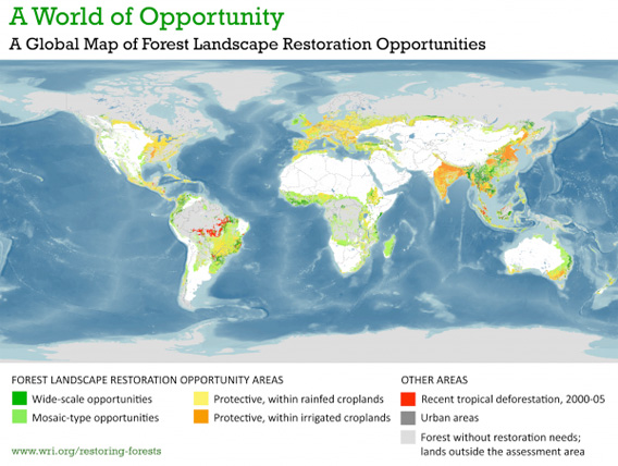
1.5 billion hectares (5.8 million square miles) of land are suitable for forest restoration, according a new analysis by the Global Partnership on Forest Landscape Restoration, a partnership between the World Resources Institute, South Dakota State University, and IUCN.
The global map shows where forests have “great potential for recovery”, including great swathes of deforested landscapes (about two-thirds of the opportunity) across Africa, Brazil, and Indonesia as well as degraded forests and woodlands. The analysis breaks opportunities into two classes: wide-scale and mosiac (or patchy) forest generation.
The study find that most of the opportunities occur not in frontier areas where deforestation is presently occurring, but in regions where forest degradation and deforestation have already occurred. It notes that restoration opportunities vary depending on local conditions.
“These areas should not all be restored in the same fashion,” states the World Resources Institute (WRI) on its web site. “There is no one-size-fits-all solution. Each forest landscape is unique and needs its own restoration design which responds in a balanced way to societal preferences and needs.”
“Lands that are currently used for crop production or grazing, for example, are not suitable for wide-scale restoration. They may, however, offer opportunities for restoration in mixed land-use mosaics. Many historically deforested areas belong to this category.”
The map was released as world leaders met in Cancun for climate talks. One of the hottest areas of discussion in Cancun was the so-called reducing emissions from deforestation and degradation (REDD) mechanism, which proposes to pay tropical countries for protecting, restoring, and “sustainably managing” their forests. The conference ended with an agreement to pursue REDD.
Some countries are already seeing forest regeneration. Costa Rica and Vietnam are among the nations that have seen recovery of forest cover outside industrial plantations.
The Global Partnership on Forest Landscape Restoration map is based on relatively coarse (1×1 km) remote sensing data and considers current land cover, land use, population density and other factors. It does not incorporate tenure arrangements and land-use dynamics, which could complicate forest recovery and restoration.
For more information, please visit wri.org/restoring-forests.


